# 6663
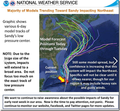
Looking like a gigantic question mark (?), the majority of the forecast models for (currently CAT 2 Hurricane) Sandy now have the storm making a sharp left turn towards the Northeast Coast early next week.
Sandy’s eventual path, and strength at that time is impossible to gauge right now, but the NWS is asking East Coast residents to pay attention.
This from the NOAA National Severe Storms Laboratory Facebook Page.
Pay attention east coast!
The majority of computer models have trended toward bringing the system north into the Atlantic just off of the Eastern Seaboard and taking a sharp left turn, ultimately moving into the Northeast. Where exactly the system will go remains up in the air. Models are showing the storm entering New Brunswick to as far south as southern NJ. More info as we get it and we will be following this extremely close over the next 3-4 days. Please share this graphic to keep family and friends informed.
While Sandy is unlikely to maintain hurricane status that far north this late in the year, residents anywhere from the Mid-Atlantic all the way up to the Maritimes need to pay attention, and be prepared to deal with what could be an extremely strong Nor’Easter or post-tropical storm.
This Hazardous Weather Outlook from NWS Boston, MA. issued today at 5:47am.
THIS HAZARDOUS WEATHER OUTLOOK IS FOR NORTHERN CONNECTICUT...CENTRAL MASSACHUSETTS ... EASTERN MASSACHUSETTS ... NORTHEASTERN MASSACHUSETTS ... SOUTHEASTERN MASSACHUSETTS ...WESTERN MASSACHUSETTS ...SOUTHERN NEW HAMPSHIRE ... NORTHERN RHODE ISLAND AND SOUTHERN RHODE ISLAND.
.DAY ONE...TODAY AND TONIGHT.
HAZARDOUS WEATHER IS NOT EXPECTED AT THIS TIME.
.DAYS TWO THROUGH SEVEN...FRIDAY THROUGH WEDNESDAY.
CONFIDENCE CONTINUES TO INCREASE FOR IMPACTS FROM SANDY...WHETHER IN TROPICAL OR POST TROPICAL FORM...EARLY NEXT WEEK. THE REGION
COULD SEE EITHER A CLOSE PASS OR A DIRECT HIT FROM LATE MONDAY TO TUESDAY AND BEYOND. IMPACTS MAY INCLUDE HIGH SEAS AND STORM SURGE THAT COULD COMBINE WITH HIGH ASTRONOMICAL TIDES TO PRODUCE COASTAL FLOODING...WIND GUSTS POTENTIALLY REACHING HURRICANE FORCE CAUSING DOWNED TREES AND POWER LINES AS WELL AS HEAVY RAINFALL
RESULTING IN INTERIOR FLOODING.
Anyone living in the path of this storm, including those living inland, should be making preparations now to deal with it’s arrival.
When it comes to getting the latest information on hurricanes, your first stop should always be the National Hurricane Center in Miami, Florida. These are the real experts, and the only ones you should rely on to track and forecast the storm.
The second official information source you should have bookmarked is your local Office of Emergency Management. There you will find information about evacuation zones, shelters, and emergency decrees in your area.
If you are on Twitter, you should also follow @FEMA, @CraigatFEMA, @NHC_Atlantic, @NHC_Pacific and @ReadydotGov.
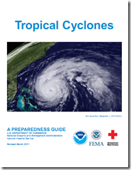
Whether Sandy retains tropical characteristics or not, If you haven’t already downloaded the Tropical Cyclone Preparedness Guide, now would be an excellent time to do so. It is a short (12-page), easy to follow guide that will walk you through the basics of understanding (and surviving) hurricanes and tropical storms.

