# 8796
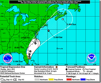
While it may not currently look like much on radar or In the satellite photos - a low pressure area that slipped off the South Carolina coastline a few days ago and drifted south over the Gulf Stream - has now gathered steam, and overnight was declared the first tropical depression of the 2014 Atlantic Hurricane Season.
From National Hurricane Center’s 5am discussion:
Numerical guidance shows favorable conditions for intensification with weak shear and developing upper-level outflow over the cyclone during the next 72 hours or so. The official intensity forecast now shows the system becoming a hurricane, which is similar to the latest intensity model consensus.
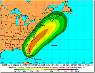
By the time this system reaches the Outer Banks of North Carolina, it could be a Category 1 hurricane. Here is the NHC’s Tropical Storm Force Wind Speed Probabilities over the next 120 hours. As you can see, most of heaviest winds are forecast to stay offshore.
Nonetheless, this storm has the potential to create life-threatening conditions along the coast, and a Tropical Storm Watch is in effect for the East Coast of Florida from Fort Piece to Flagler Beach. Watches and warnings will likely be extended northward over the next day or two.
While not likely to be a major storm, the forecasting of future intensity changes in tropical systems remains a big challenge. So anyone in its potential path should take the time today to review their hurricane preparedness plans and supplies, with an eye towards such issues as:
- How you will communicate with family & friends during and after a disaster, and where you will meet if you are separated
- How you will deal with those with specific needs, such as children, the elderly, or those with medical conditions
- To stockpile ample water, food, any required Rx meds, along with a first aid kit
- How you will cook, or provide light, or receive emergency radio transmissions if the power is out for days or longer
- Where you will go if you are told to evacuate – and how you will get there
- And last, but certainly not least, how you will care for your pets during and after a disaster.
Last month, in Hurricane Preparedness Week: Make A Plan, we discussed these issues. For more information, Ready.gov has an extensive Hurricane preparedness website, with advice on what to do before, during, and after the storm.
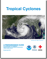
If you haven’t already downloaded the updated Tropical Cyclone Preparedness Guide, now would be an excellent time to do so.
When it comes to getting the latest information on hurricanes, your first stop should always be the National Hurricane Center in Miami, Florida. These are the real pros, and the only ones you should rely on to track and forecast the storm.
- Tropical storm watches will be issued when tropical storm conditions are possible along the coast within 48 hours.
- Tropical storm warnings will be issued when those conditions are expected within 36 hours. Similar increases in lead-time will apply to hurricane watches and warnings.
NOAA’s NWS National Hurricane Center in Miami also has a Facebook page, where you can keep up with the latest tropical developments.
The second official information source you should have bookmarked is your local Office of Emergency Management. Here you’ll be able to access local warnings, flood maps and evacuation information. To find your local one, you can Google or Yahoo search with your county/parish name and the words `Emergency Management’.
And lastly, if you are on Twitter, you should also follow @FEMA, @CraigatFEMA, @NHC_Atlantic, @NHC_Pacific and @ReadyGov.


