
#14,182
The National Hurricane Center upgraded the Gulf disturbance we've been following for the past couple of days to a Tropical Storm this morning, and while conditions aren't perfect, additional strengthening is expected before it makes landfall 48 to 72 hours from now.
Exactly where landfall will occur is still in question, as steering currents are weak and the storm is still organizing, but for now somewhere along the Louisiana coast is most likely.There is enough uncertainty, however, that residents of Mississippi and Texas aren't out of the woods yet, as explained in this morning's NHC discussion:
The initial motion is a rather uncertain 270/4. Barry is being steered by a weak low- to mid-level ridge to the north, and a weakness in the ridge is forecast to develop during the next 24-48 h. This should allow the cyclone to turn northwestward and eventually northward.
However, there is a large spread in the track guidance.
The HWRF and HMON forecast Barry to move almost due north from its current position with a landfall in Mississippi, while the UKMET takes the cyclone to the upper Texas coast. The GFS, ECMWF, and Canadian models lie between these extremes. Overall, there has been a slight eastward shift of the guidance envelope, so the new forecast track is also adjusted slightly to the east. It should be noted, though, that the new track is west of the consensus models.
The Key Messages from the NHC this morning are:

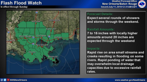
While Barry may not be the most impressive storm to threaten the northern Gulf coast, recent heavy rains, and overburdened streams and rivers in this region could substantially amplify it's impact.
A scenario already being warned about by @NolaReady - the City of New Orleans’ emergency preparedness campaign.
 |
| @NolaReady Twitter Feed |
For more on after-storm safety, you may want to visit my earlier blog:
What Lies Beneath (the flood waters)