#14,260
Much has been made the past month on how quiet this year's Atlantic (and for that matter, Eastern Pacific) hurricane season has been (see Palm Beach Post Why August may make history this hurricane season), but as we approach the last week of August, we are starting to see some signs of activity.
The National Hurricane Center (NHC) is watching a disturbed area of weather off the Southeast Coast of Florida, and this morning has forecast that it has a 70% chance of becoming a tropical depression over the next 5 days.This morning's tropical outlook reads:
ZCZC MIATWOAT ALL TTAA00 KNHC DDHHMM
Tropical Weather Outlook
NWS National Hurricane Center Miami FL 800 AM EDT Fri Aug 23 2019
For the North Atlantic...Caribbean Sea and the Gulf of Mexico: The National Hurricane Center is issuing advisories on Tropical Depression Chantal, located about 765 miles west of the Azores.
1. Surface and radar data indicate that a weak area of low pressure is located just east of the upper Florida Keys and the southeastern coast of the Florida peninsula. This system is producing a large area of disorganized cloudiness and showers that extends primarily northeast of the center over the northwestern Bahamas and the adjacent Atlantic Ocean.
The low is forecast to move near or over the Florida peninsula through tonight, which should limit development during that time. Environmental conditions appear conducive for development once the system moves northeastward back over the Atlantic waters on Saturday.
A tropical depression is likely to form this weekend or early next week while the low moves from near the coast of east-central Florida to offshore of the southeastern United States coast. Regardless of development, locally heavy rains are possible over the northwestern Bahamas and southern and central Florida through the weekend.
* Formation chance through 48 hours...medium...40 percent.
* Formation chance through 5 days...high...70 percent.While this doesn't appear to have the makings of a major storm, it is forming and expected to travel over very warm Gulf stream waters, and interests along the East Coast of Florida and the Southeastern U.S should monitor its progress.
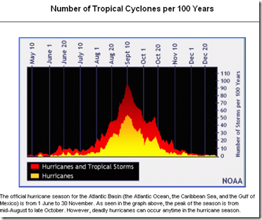
Although the Atlantic hurricane season begins June 1st, the heart of hurricane season runs from roughly August 20th to the end of October. Statistically, hurricane activity peaks around September 10th (see chart below).
If you live anywhere where in `hurricane country' and haven't done so already, now is a good time to visit NOAA's Weather-Ready Nation 2019's Hurricane Preparedness week web page, and decide what you need to do now to keep you, your family, and your property safe during the coming tropical season.
There are some excellent internet hurricane resources online, but the two I heartily recommend are Mark Sudduth's excellent YouTube channel and http://hurricanetrack.com/ - and for true weather nerds like me - Mike's https://spaghettimodels.com/ is a daily stop.
But your primary source of
forecast information should always be the National Hurricane Center in Miami, Florida.
These are the real experts, and the only ones you should rely on to track and forecast the storm.If you are on Twitter, you should also follow @FEMA, @NHC_Atlantic, @NHC_Pacific and @ReadyGov and of course take direction from your local Emergency Management Office.
For some recent blogs on preparing for hurricanes - and other major disasters - you may wish to revisit:
CDC EPIC: Hurricane Preparedness Webinar
What Lies Beneath (the flood waters)
7 Days Without A Disaster Kit Makes One Weak
Preparedness: Some Emergency Power Solutions

