#17,470
Six weeks ago, in El Niño & The CSU Initial Atlantic Hurricane Season Forecast, we looked at prospect for an El Niño setting up in the Pacific the summer, and early predictions for fewer Atlantic basin tropical storms for the 2023 season.
While the warming of Pacific equatorial waters (El Niño) doesn't guarantee a quiet Hurricane season, statistically El Niño years have fewer storms form in the Atlantic, while more storms are produced in the Pacific.
Today NOAA released their initial 2023 Atlantic Hurricane Season Outlook, and while it calls for slightly more activity that last April's CSU forecast (13 named storms, 6 hurricanes (2 major)) - after several years of intense activity - it is a refreshing return to a `near-normal' season.
The usual caveats apply, since 1992 was an El Niño year, and it saw one of the most destructive hurricanes on record (Andrew) hit South Florida, during what was otherwise a lackluster hurricane season. 1969 was an active El Niño year, which saw CAT 5 hurricane Camille slam into the upper gulf coast.
While I'm slightly heartened by these predictions, it just takes one bad hurricane to ruin your entire summer, so I will still be preparing the same as I do every year (see National Hurricane Preparedness Week 2023).
The link, and some excerpts, from today's press release follow.
NOAA predicts a near-normal 2023 Atlantic hurricane season
El Nino, above-average Atlantic Ocean temperatures set the stage
May 25, 2023
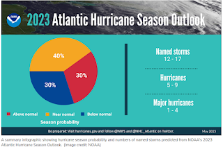
NOAA forecasters with the Climate Prediction Center, a division of the National Weather Service, predict near-normal hurricane activity in the Atlantic this year. NOAA’s outlook for the 2023 Atlantic hurricane season, which goes from June 1 to November 30, predicts a 40% chance of a near-normal season, a 30% chance of an above-normal season and a 30% chance of a below-normal season.
NOAA is forecasting a range of 12 to 17 total named storms (winds of 39 mph or higher). Of those, 5 to 9 could become hurricanes (winds of 74 mph or higher), including 1 to 4 major hurricanes (category 3, 4 or 5; with winds of 111 mph or higher). NOAA has a 70% confidence in these ranges.
(SNIP)
The upcoming Atlantic hurricane season is expected to be less active than recent years, due to competing factors — some that suppress storm development and some that fuel it — driving this year's overall forecast for a near-normal season.
After three hurricane seasons with La Nina present, NOAA scientists predict a high potential for El Nino to develop this summer, which can suppress Atlantic hurricane activity. El Nino’s potential influence on storm development could be offset by favorable conditions local to the tropical Atlantic Basin. Those conditions include the potential for an above-normal west African monsoon, which produces African easterly waves and seeds some of the stronger and longer-lived Atlantic storms, and warmer-than-normal sea surface temperatures in the tropical Atlantic Ocean and Caribbean Sea which creates more energy to fuel storm development. These factors are part of the longer term variability in Atlantic atmospheric and oceanic conditions that are conducive to hurricane development — known as the high-activity era for Atlantic hurricanes — which have been producing more active Atlantic hurricane seasons since 1995.
While I'll be doing usual hurricane preparedness blogs - and I follow Mark Sudduth's Hurricane Track, and Mike's Weather page - your primary source of forecast information should always be the National Hurricane Center in Miami, Florida.
These are the real experts, and the only ones you should rely on to track and forecast the storm.If you are on Twitter, you should also follow @FEMA, @NHC_Atlantic, @NHC_Pacific and @ReadyGov, and of course take direction from your local Emergency Management Office.
For more Hurricane resources from NOAA, you'll want to follow these links.
HURRICANE SAFETY
ADDITIONAL RESOURCES
