# 4976
Hurricane Paula formed rapidly yesterday in the Southwestern Caribbean and for now, appears to be a threat mostly to the Yucatan Peninsular.
That could change, however, over the next few days as steering currents in that area of the tropics become less certain.
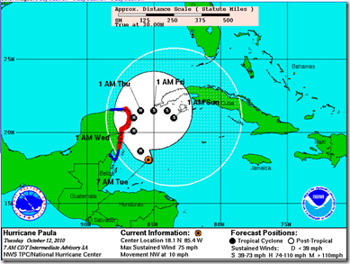
Right now, the National Hurricane Center’s 5-day forecast has the storm doing a loop between Yucatan and the western tip of Cuba.
But the discussion issued at 5 am points out:
THE OFFICIAL TRACK FORECAST KEEPS THE TROPICAL CYCLONE IN THE NORTHWEST CARIBBEAN FOR THE NEXT 5 DAYS. AS NOTED IN EARLIER DISCUSSIONS... CONFIDENCE IN THE LATTER PORTION OF THE TRACK FORECAST IS LOW.
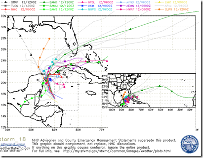
This morning’s `spaghetti models’ show a more confused picture, meaning that interests throughout the Caribbean and South Florida should keep an eye on developments.

Hurricane season runs another 6 weeks, and late season storms tend to form in this part of the Caribbean.
While the US coastline has had an easy year of it thus far, the forecasters were correct when they said we’d see an above-average year.
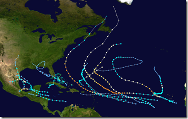
Luckily – much like we saw in 1995– most of the storms have stayed out to sea.
2010 Hurricane Tracks
It only takes one bad storm to make a memorable season, however.
While Paula may stay well to our south, heavy rains and severe weather are certainly a possibility for southern Florida and portions of the eastern seaboard over the coming days.
But you don’t have much to worry about . . . as long as you are prepared.
You are already prepared . . . aren’t you?
Track this budding storm (and any other tropical threats) on the NHC website at:
http://www.nhc.noaa.gov/index.shtml
Also, if you are on Twitter, follow @FEMA and @CraigAtFEMA for timely updates and preparedness advice.

