#13,577
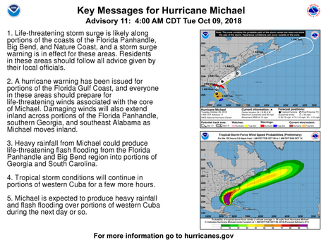
Although still technically still a (strong) CAT 1 storm, Michael is expected to intensify over the next 24 hours, reaching CAT 3 strength before making landfall - tomorrow afternoon - in the Florida panhandle.
When you add in the concave shape of the coastline to the right of where the storm is expected to make landfall, you have a recipe for extreme (8 to 12 foot) storm surge, in addition to the damage due to CAT 3 winds.Even those living along Florida's heavily populated west coast are apt to see coastal flooding, tropical storm force winds, and heavy rains. Some small tornadoes may spin off from this storm as well.
Residents in the path of this storm now have less than 24 hours to prepare. This morning's key messages from the National Hurricane Center are: