 |
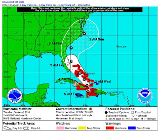
| Oct 4th 5am - Credit NHC |
#11,790
Although Hurricane Matthew is still 700 miles south east of Miami, and venting its Category 4 fury on Haiti and Eastern Cuba, this morning's computer runs continue to show a bend towards Florida's east coast later in the week
Exactly how close it will come, and how strong it will be are still open questions
But the models suggest Matthew could rake the coast from South Florida to Virginia before the weekend is done. And that means that millions of residents who have never experienced a `real' hurricane may find themselves doing exactly that in the next few days.
First the Key messages this morning from the National Hurricane Center, then I'll be back with more on preparing for the storm.
KEY MESSAGES:
1. Matthew is likely to produce devastating impacts from storm surge, extreme winds, heavy rains, flash floods, and/or mudslides in portions of the watch and warning areas in Haiti, Cuba, and the Bahamas. Please consult statements from the meteorological services and other government officials in those countries.
2. Direct hurricane impacts are possible in Florida later this week. Tropical storm and/or hurricane watches are likely later this morning for portions of the Florida peninsula and the Florida Keys.
3. Tropical storm or hurricane conditions could affect portions of Georgia, South Carolina, and North Carolina later this week or this weekend, even if the center of Matthew remains offshore. It is too soon to specify what, if any, direct impacts Matthew might have on the remainder of the U.S. east coast farther north. At a minimum, very dangerous beach and boating conditions are likely along much of the U.S. east coast later this week and weekend.
FORECAST POSITIONS AND MAX WINDS
INIT 04/0900Z 17.8N 74.4W 125 KT 145 MPH
12H 04/1800Z 19.2N 74.3W 120 KT 140 MPH
24H 05/0600Z 21.0N 74.6W 115 KT 130 MPH
36H 05/1800Z 22.8N 75.5W 115 KT 130 MPH
48H 06/0600Z 24.6N 76.9W 110 KT 125 MPH
72H 07/0600Z 28.0N 79.6W 105 KT 120 MPH
96H 08/0600Z 31.7N 79.7W 90 KT 105 MPH
120H 09/0600Z 35.5N 75.5W 85 KT 100 MPH
While models and forecasts can change, and the storm might stay far enough out to sea to avoid major damage in the U.S., the smart move is for residents along the Southeastern coast to begin to prepare.
If you live in Florida, you should immediately bookmark the FloridaDisaster.Org website, and find your local Office of Emergency Management - and bookmark that as well.
If you live in another state, you can find your Office Of Emergency Management in your phone book, or do a Google search. Your local Emergency Operations Center can provide you with flood zone maps, evacuation advice and routes, and shelter locations.
While the lead up to - and riding out the storm - can be difficult . . . often the biggest challenges come in the days (or even weeks) after the storm has passed.
So, over the next 24-48 hours I'll be running a series of updated hurricane preparedness blogs on everything from how to evacuate, to food safety when the power goes out, to infectious disease threats in a post hurricane environment.
In the meantime, you may want to check out Ready.gov's Hurricane preparedness advice.