
#12,661
We are just 1/3rd of the way into this year's Atlantic Tropical season, and while we've already seen 5 named systems, August is when we expect things to pick up substantially. This mornings (Aug 5th) Tropical weather outlook shows two areas to watch, with both entering favorable conditions for development.
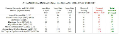
Yesterday, Colorado State University’s Tropical Meteorology Project released their August update, which continues to call for a more active tropical season than usual, upping their forecast from 15 named storms last June forecast to 16.
Although this active forecast can't tell any of us whether we'll be impacted by a hurricane this year, it only takes one serious storm in a highly populated area to cause a major disaster.
The peak of the Atlantic Hurricane season comes in mid-September, but August is when we start to see the long track storms that form in the Eastern Atlantic, often giving them enough time to ramp up to major hurricane strength.

August has produced some of the most famous hurricanes in history, including Katrina (2005), Charley (2004), Andrew (1992), and Camille in 1969. Notorious Hurricane Donna (1960), formed in August but wasn't upgraded to a hurricane until Sept 1st.
Despite the close approach of Hurricane Mathew last year, and New York City's Super storm Sandy in 2012, it has been nearly 12 years since a major (CAT 3+) hurricane has made landfall in the United States.
The last land falling major hurricane was Wilma, striking Miami and South Florida, in October of 2005.This is the longest `dry spell' on record - the historical average being once every 3 years - and while greatly welcomed by coastal residents, is a record that cannot go on forever.
So, if you haven’t already downloaded the updated Tropical Cyclone Preparedness Guide, and visited NOAA's Weather-Ready Nation Hurricane Preparedness Week 2017 web page, now would be an excellent time to do so.
When it comes to getting the latest information on hurricanes, your first stop should always be the National Hurricane Center in Miami, Florida. These are the real experts, and the only ones you should rely on to track and forecast the storm.

If you are on Twitter, you should also follow @FEMA, @NHC_Atlantic, @NHC_Pacific and @ReadyGov.Throughout September this blog will be participating in National Preparedness Month by running some edited and updated older preparedness essays, along with some new ones.
While I always hope this will inspire people to become better prepared for emergencies, it is never too soon to start that process. For some of my recent Hurricane Preparedness blogs, you may wish to revisit:
Hurricane Preparedness Week 2017 (May 7th - May 13th)
Matthew: For When After The Storm Passes
Matthew : When Evacuation Becomes The Better Part Of Valor