 |
| Forecast 16 |
#12,716
What a difference 6 hours can make, particularly when a tropical system moves into the right conditions. This morning, the forecast was for a strong CAT 1 storm reaching the Texas coast on Saturday morning, now it looks like either a strong CAT 2 or CAT3 storm.
Should Harvey have CAT 3 strength at landfall, it would be the first major hurricane to hit the continental United States since Wilma in October of 2005, and would end the longest drought in major hurricane hits in recorded history.
New details from the 10am CDT forecast follow. All those in the path of this storm need to take it very seriously.
 |
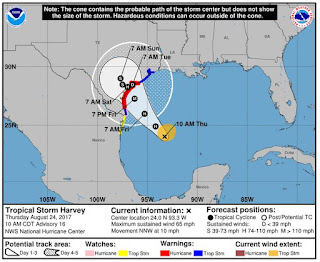
| Click to Enlarge |
FORECAST POSITIONS AND MAX WINDS
INIT 24/1500Z 24.0N 93.3W 55 KT 65 MPH
12H 25/0000Z 24.9N 94.2W 70 KT 80 MPH
24H 25/1200Z 26.0N 95.3W 90 KT 105 MPH
36H 26/0000Z 27.3N 96.3W 100 KT 115 MPH
48H 26/1200Z 28.3N 97.0W 95 KT 110 MPH...INLAND
72H 27/1200Z 29.0N 97.7W 40 KT 45 MPH...INLAND
96H 28/1200Z 28.5N 97.5W 35 KT 40 MPH...INLAND
120H 29/1200Z 28.5N 96.5W 30 KT 35 MPH...INLAND
Storm surge estimates, particularly for the coastal back bays, have increased to over 9 feet.

With tropical storm force winds arriving along the coastline as early as 8am tomorrow morning, all residents in the path of the storm should be making preparations for Harvey's arrival - and any decisions to evacuate low lying or unsafe areas - while weather conditions still permit.
Residents should closely monitor the National Hurricane Center in Miami, Florida and their local Emergency Operations Center for advisories and updates. These are the real experts, and the only ones you should rely on to track and forecast the storm.
If you are on Twitter, you should also follow @FEMA, @NHC_Atlantic, @NHC_Pacific and @ReadyGov.