 |
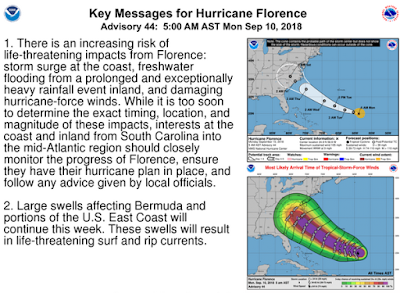
| 5am Sept 10th - Credit NHC |
#13,495
Florence, once again a hurricane, is rapidly intensifying as it treks towards the Southeastern United States. This storm should become a major hurricane later today, and it is expected to be a CAT3/CAT4 storm at landfall.
While the models have come into pretty good alignment, the margin for error gets wider the further out in time you look. At day 4 it is roughly 150 nm either side of the track (stippled area of the cone).So while the map above suggests a North Carolina landfall - both South Carolina and Virginia remain in play - and any major deviations in the next couple of days could shift the track further north or south.
Furthermore, as these storms gain latitude they tend to grow larger, and so the swath of destruction will likely extend outside the forecast cone. Watches and warnings have not been issued yet, but everyone along the mid-Atlantic and Southeastern coast should be preparing for this storm's arrival.
First this morning's key messages from the NHC, and then I'll return with a bit more.
FORECAST POSITIONS AND MAX WINDS
INIT 10/0900Z 24.9N 58.9W 90 KT 105 MPH
12H 10/1800Z 25.4N 60.5W 110 KT 125 MPH
24H 11/0600Z 26.1N 63.1W 120 KT 140 MPH
36H 11/1800Z 27.3N 66.2W 125 KT 145 MPH
48H 12/0600Z 28.8N 69.3W 130 KT 150 MPH
72H 13/0600Z 32.2N 74.8W 125 KT 145 MPH
96H 14/0600Z 34.5N 78.1W 100 KT 115 MPH...INLAND
120H 15/0600Z 35.8N 79.6W 40 KT 45 MPH...INLAND
While the immediate concern will be extremely high winds, hazardous storm surge, and heavy rains along the coast, inland fresh water flooding is always a concern - and as we saw last year with Hurricane Harvey in Texas - heavy rains can do a great deal of damage.
While it is too soon to forecast, some of the computer models suggest the storm may begin to slow down as it approaches the coast, and that Florence could be a multi-day rainmaker over the region.We'll have to see how this plays out, but even people living hundreds of miles away from this storm's landfall could be adversely affected, and should be monitoring the storm.
As always, when it comes to getting the latest information on hurricanes, your first stop should always be the National Hurricane Center in Miami, Florida. These are the real experts, and the only ones you should rely on to track and forecast the storm.
If you are on Twitter, you should also follow @FEMA, @NHC_Atlantic, @NHC_Pacific and @ReadyGov.
For more on preparing for the storm, you may wish to revisit:
#Natlprep: No Time Like The Present To Prepare
