#14,266
Still four days from expected landfall, Tropical Storm Dorian - which is expected to become a hurricane after it passes Puerto Rico - has pretty much all of the Florida peninsula under the gun.
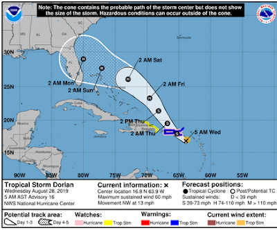
This morning's 5am forecast has moved the forecast track, and landfall, further north and has increased the storm's expected intensity to a CAT 2 Hurricane 96 hours from now - but cautions that:
`Uncertainty in the intensity forecast late this week remains higher than usual due to a large spread in the model guidance.'While it appears that the upper east coast of Florida is at greatest risk right now, with each model run (see below) the forecast track (and intensity) may change, and so anyone who lives between the Florida Keys and South Carolina should be paying attention.
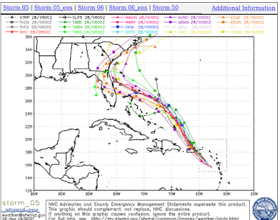
At least one of these models brings Dorian directly over my home, while others put it so far away, I probably wouldn't feel any impact at all. Such is the reality of life in Florida during Hurricane Season . . . you may not get hit, but most year's you'll find yourself inside the cone . . . sometimes more than once.
Reason enough to prepare every year, and to be ready to evacuate if the need arises. From today's 5am Discussion from the National Hurricane Center:
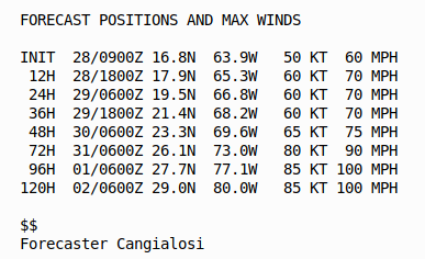
Nearly all of the intensity models show Dorian becoming a hurricane in about 2 days, with additional strengthening beyond that time. The NHC intensity forecast is increased from the previous one, especially at the longer forecast times, to be in better agreement with the latest models. This forecast, however, is still on the lower end of the guidance envelope, so additional upward adjustments could be needed if the guidance trends persists. It is also worth noting that the global models show Dorian increasing in size by the time it nears the southeast U.S.
A lot could happen between now and Labor Day to impact Dorian's track and intensity - and while the storm could lose strength - the NHC is not ruling out a much bigger storm than currently forecast.
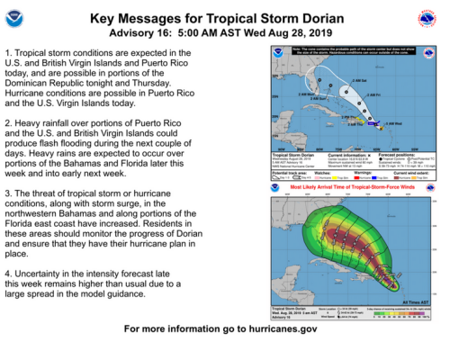
Regardless of its eventual path and intensity, the media is going to start beating the drums louder today - and anyone who hasn't prepared needs to do so now - before the essentials (batteries, water, canned food, plywood, etc.) vanish from store shelves.This morning's Key Messages from the NHC follow:
While there are some great weather resources on the internet, your primary source of forecast information should always be the National Hurricane Center in Miami, Florida.
These are the real experts, and the only ones you should rely on to track and forecast the storm.If you are on Twitter, you should also follow @FEMA, @NHC_Atlantic, @NHC_Pacific and @ReadyGov and of course take direction from your local Emergency Management Office.
As for this blog, it looks like I'll be kicking off my National Preparedness Month coverage a couple of days early this year.