
#16,967
Not that I'm complaining, since I live in the heart of hurricane country, but the tropical Atlantic has been unusually quiet since early July, with storm development hampered by an abundance of dry Saharan air and unfavorable winds.
In fact, its been the quietest start to hurricane season in 30 years.
Conditions were so unfavorable a month ago that I skipped my usual August Tropical Climatology blog this year, and they are only now starting to change (see NOAA 5 day outlook above).
Normally, by Sept 1st, we'd already have seen our 2nd hurricane, and our 5th named storm (see chart below), but this year we've only seen 3 tropical storms (Alex, Bonnie & Colin).Right now, only one area (central tropical Atlantic) appears ripe for development, but the area in the western Caribbean bears watching.

September is historically the most active month for hurricanes (see chart below), with activity remaining elevated for most of October. So we aren't out of the woods yet. And it is worth remembering that in 1992, we didn't see our first named storm until mid-August, but it was one to remember; CAT 5 Hurricane Andrew which slammed into South Florida on August 24th.

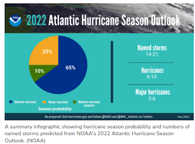
While it remains to be seen if this year's hurricane season will come close to the early season predictions (see below), last year there were 12 named storms active during the month of September. And as Andrew proved in 1992, it only takes one to make a huge impact.
While I've enjoyed the unexpected two-month respite, the tropics have my attention again, and if you live anywhere in the shaded areas in the map below, it should have yours as well.

If you live in hurricane country, now is a good time to visit NOAA's National Hurricane Preparedness web page, and decide what you need to do now to keep you, your family, and your property safe during the coming tropical season.
While this blog, and many other internet sources (I follow Mark Sudduth's Hurricane Track, and Mike's Weather page), will cover this year's hurricane season. your primary source of forecast information should always be the National Hurricane Center in Miami, Florida.
These are the real experts, and the only ones you should rely on to track and forecast the storm.
If you are on Twitter, you should also follow @FEMA, @NHC_Atlantic, @NHC_Pacific and @ReadyGov and of course take direction from your local Emergency Management Office.