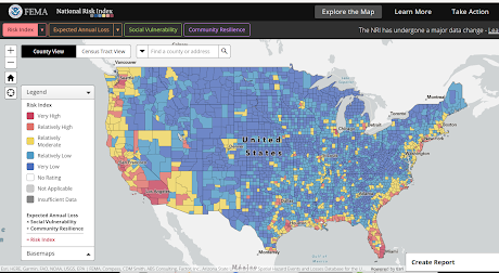
We looked at FEMA's National Risk Index (NRI) map two years ago, but since then it has undergone a major revision (and new data has been added), which has changed some of its rankings.
A side-by-side comparison of the state of Florida (then vs now) illustrate these changes.

Recent hurricanes have obviously changed the risk profile, particularly where I live, on Florida's west coast. Add in the continual influx of new residents, many of whom are unfamiliar with hurricanes, and you have the ingredients for a disaster.
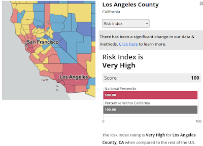
But if you want to talk about the most people living in the highest risk region, then it would be hard to top Southern California (see map below). Los Angeles County ranks as the most disaster-prone county in the nation.
These indexes refer to the relative frequency of disasters, which is why even a low risk area like Sharkey County, Mississippi - which saw an F4 tornado last week - can still be devastated.
While I promote an `all hazards' approach to preparedness, knowing the the type of risks where you live is an important first step to getting better prepared. Living in Florida, earthquakes aren't something I have to worry about, but hurricanes, tornadoes, wildfires are genuine concerns.By clicking on any county, this interactive map provides a pop-up scrollable list of disaster risks and demographic information for that region. You can also elect to create and download a full and highly detailed report.
Whether you want to look up your own risks, or find someplace a bit less risky or more resilient to move to, this interactive website will give you plenty to consider.

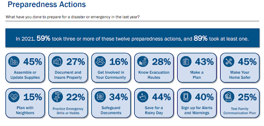
Although that is up 2% from the 2019 survey, it is far from ideal.
So, no matter where you live . . . if a disaster struck your region today, and the power went out, stores closed their doors, and water stopped flowing from your kitchen tap for the next 7 to 14 days . . . you are you prepared with:
- A battery operated NWS Emergency Radio to find out what was going on, and to get vital instructions from emergency officials
- A decent first-aid kit, so that you can treat injuries
- Enough non-perishable food and water on hand to feed and hydrate your family (including pets) for the duration
- A way to provide light when the grid is down.
- A way to cook safely without electricity
- A way to purify or filter water
- A way to handle basic sanitation and waste disposal.
- A way to stay cool (fans) or warm when the power is out.
- A small supply of cash to use in case credit/debit machines are not working
- An emergency plan, including meeting places, emergency out-of-state contact numbers, a disaster buddy, and in case you must evacuate, a bug-out bag
- Spare supply of essential prescription medicines that you or your family may need
- A way to entertain yourself, or your kids, during a prolonged blackout
The Gift of Preparedness
#NatlPrep: When Evacuation Is The Better Part of Valor
Sweltering In Place (2022 Edition)
Hurricane Preparedness: Some Simple Off-The-Shelf Solar Solutions For Power Outages