# 6345
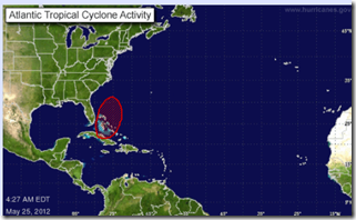
It isn’t even the first of June, the official start of the Atlantic Hurricane Season, and already forecasters are watching a second area of disturbed weather with the potential to become a named storm.
Earlier this month, Tropical Storm Alberto formed briefly off the South Carolina coast.
This morning, forecasters at the NHC are giving an area of disturbed weather a 70% chance of developing into a tropical system over the next 48 hours.
Should that happen, it would be christened `BERYL’.
SPECIAL TROPICAL WEATHER OUTLOOK
NWS NATIONAL HURRICANE CENTER MIAMI FL
425 AM EDT FRI MAY 25 2012FOR THE NORTH ATLANTIC...CARIBBEAN SEA AND THE GULF OF MEXICO...
A BROAD AREA OF LOW PRESSURE LOCATED NEAR THE NORTHWESTERN BAHAMAS IS PRODUCING AN EXTENSIVE AREA OF SHOWERS AND THUNDERSTORMS OVER THE BAHAMAS AND CUBA. WHILE THE ORGANIZATION OF THIS SYSTEM HAS NOT IMPROVED OVER THE PAST FEW HOURS... ENVIRONMENTAL CONDITIONS ARE EXPECTED TO BECOME MORE CONDUCIVE FOR THE FORMATION OF A SUBTROPICAL OR TROPICAL CYCLONE BY SATURDAY OR SUNDAY. THE LOW SHOULD MOVE TOWARD THE NORTHEAST AT ABOUT 15 MPH DURING THE NEXT DAY OR SO...FOLLOWED BY A GRADUAL TURN BACK TOWARD THE WEST ON SATURDAY. THIS SYSTEM HAS A HIGH CHANCE...70 PERCENT... OF BECOMING A TROPICAL OR SUBTROPICAL CYCLONE DURING THE NEXT 48 HOURS.
LOCALLY HEAVY RAINFALL...FLOODING...AND GUSTY WINDS ARE POSSIBLE TODAY OVER PORTIONS OF THE NORTHWESTERN AND CENTRAL BAHAMAS...AS
WELL AS CENTRAL CUBA. INTERESTS ALONG THE SOUTHEASTERN UNITED STATES COAST SHOULD CLOSELY MONITOR THE PROGRESS OF THIS SYSTEM
OVER THE MEMORIAL DAY WEEKEND. ANOTHER SPECIAL TROPICAL WEATHER OUTLOOK FOR THIS SYSTEM WILL BE ISSUED LATER TODAY. FOR ADDITIONAL INFORMATION ON THIS SYSTEM...PLEASE SEE HIGH SEAS FORECASTS ISSUED BY THE NATIONAL WEATHER SERVICE...AND PRODUCTS FROM YOUR LOCAL WEATHER OFFICE.ELSEWHERE...TROPICAL CYCLONE FORMATION IS NOT EXPECTED DURING THE NEXT 48 HOURS.
While off-season tropical storms and depressions are not uncommon, these systems only rarely achieve hurricane status.
The last time that happened was in December of 2005, with long-lasting Hurricane Epsilon. Since then, we’ve seen 6 off-season tropical systems form of less than hurricane strength.
All of this serves as a reminder that storms don’t read calendars, and that it pays to be prepared all year-round.
Next week kicks off National Hurricane Preparedness Week, but today isn’t too soon to talk about preparing. This reminder from today’s FEMA Blog.
FEMA Urges Preparedness for Hurricanes and Severe Weather
Mobile wireless emergency alerting capabilities will be available nationwide through participating carriers
Release Date: May 24, 2012
FEMA urges individuals and businesses to take action to prepare themselves in advance of severe weather and hurricanes such as taking the pledge to prepare at www.ready.gov/pledge. This is the first step in making sure you and your family are ready for an emergency This includes filling out your family communications plan that you can email to yourself, assembling an emergency kit , keeping important papers and valuables in a safe place, and getting involved.
With the start of hurricanes season it is even more important to know your risk, take action, and be an example. While hurricanes often offer some warning that a threat is approaching, severe weather can occur at anytime and in any place, including high winds, inland flooding, severe storms and tornadoes.
