***UPDATED***
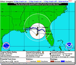
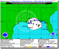
As I wrote this morning, the National Hurricane Center’s forecast track for T.S. Debby was apt to change, and as of the 5pm update, it most certainly has.
The new forecast track (above) is still one of relatively `low confidence’, as the storm is moving slowly and steering currents could change. Basically, anyone along the Gulf Coast - from Texas to Florida - needs to keep an eye on this system.
11 am Forecast – Now outdated
# 6403
The 11 am discussion from the National Hurricane Center stresses just how difficult the current forecast for Tropical storm Debby is proving to be. Model are not even close to consistent right now, with two very different scenarios a possibility.
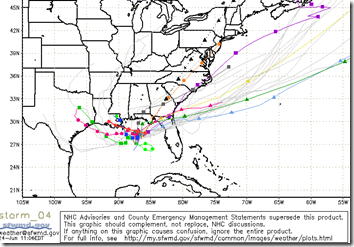
First, here are the latest computer models, from the SWFTMD website. They basically have the storm going in every direction except south-south-west. Which means that until these models coalesce, the entire gulf coast needs to keep an eye on this storm.
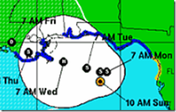
For now, based on the strength and past performance of some of these models, the NHC is going with a general movement to the west-north-west – putting the northern gulf coast as the likely target.
But as of 11 am today, Tropical Storm watches have been raised as far south as Pasco County on the west coast of Florida.
The 11 am discussion has Debby reaching minimal hurricane strength over the next several days, but much of that will depend on its ultimate path.
As the forecasters warn below WE MUST BE READY TO MAKE A CHANGE OF THE FORECAST TRACK AT ANY TIME.
TCDAT4
TROPICAL STORM DEBBY DISCUSSION NUMBER 5
NWS NATIONAL HURRICANE CENTER MIAMI FL AL042012
1000 AM CDT SUN JUN 24 2012IT IS A VERY DIFFICULT AND HIGHLY UNCERTAIN FORECAST THIS MORNING. DEBBY HAS BEEN MOVING VERY SLOWLY TOWARD THE NORTHEAST...040 AT 3
KNOTS...WHILE THE WIND RADII HAVE BEEN EXPANDING IN THE EASTERN SEMICIRCLE. THIS HAS PROMPTED ADDITIONAL TROPICAL STORM WARNINGSAND WATCHES FOR PORTIONS OF THE FLORIDA COAST.
DEBBY CONTINUES TO BE SHEARED WITH MOST OF THE THUNDERSTORM ACTIVITY NORTH AND EAST OF THE CENTER. THIS SHEAR IS EXPECTED TO CONTINUE FOR THE NEXT DAY OR SO...ALTHOUGH SOME DECREASE IN THE SHEAR IS POSSIBLE AFTER THAT...PARTICULARLY IF THE ECMWF VERIFIES. THE OFFICIAL FORECA ST IS A LITTLE LESS AGGRESSIVE THAN THE PREVIOUS FORECAST...BUT REMAINS ABOVE MOST OF THE EXPLICIT INTENSITY GUIDANCE.
THE TRACK FORECAST IS EVEN MORE COMPLEX. THE GFS INSISTS ON A TRACK TOWARD THE NORTHEAST AS DEBBY BECOMES EMBEDDED WITHIN A LARGE MID-LATITUDE TROUGH. HOWEVER...THE ECMWF AND THE HWRF BUILD A RIDGE TO THE NORTH OF DEBBY AND FORECAST A WESTWARD TRACK. GIVEN THE WESTWARD TURN INHERITED FROM THE PREVIOUS FORECAST...AS WELL AS THE HISTORICAL STRONG RECORD OF THE ECMWF...THE NEW OFFICIAL FORECAST MOVES DEBBY INITIALLY A LITTLE BIT TO THE NORTHEAST TO REFLECT CURRENT TRENDS BUT THEN TURNS THE CYCLONE BACK TOWARD THE WEST OR WEST-NORTHWEST IN 24 TO 36 HOURS. A MAJORITY OF THE GFS ENSEMBLE MEMBERS NOW ARE CONSISTENT WITH THE DETERMINISTIC RUN...WHICH WAS NOT THE CASE YESTERDAY... MAKING A STRONGER CASE FOR THE EASTWARD SOLUTION. WE MUST BE READY TO MAKE A CHANGE OF THE FORECAST TRACK AT ANY TIME.
FORECAST POSITIONS AND MAX WINDS
INIT 24/1500Z 28.0N 86.2W 50 KT 60 MPH
12H 25/0000Z 28.5N 85.8W 50 KT 60 MPH
24H 25/1200Z 28.5N 85.8W 50 KT 60 MPH
36H 26/0000Z 28.5N 86.2W 55 KT 65 MPH
48H 26/1200Z 28.7N 87.0W 60 KT 70 MPH
72H 27/1200Z 29.0N 88.4W 65 KT 75 MPH
96H 28/1200Z 29.5N 90.5W 45 KT 50 MPH
120H 29/1200Z 30.0N 91.5W 30 KT 35 MPH
And a reminder, the National Hurricane Center (NHC) has two Twitter accounts, one for the Atlantic basin (which includes the Gulf of Mexico and the Caribbean Sea):
U.S. National Hurricane Center (Atlantic) - @NHC_Atlantic
and one for the Eastern North Pacific basin:
U.S. National Hurricane Center (Eastern Pacific) - @NHC_Pacific
In addition to the Twitter notifications, NHC also provides product notifications by email. Please visit hurricanes.gov/signup.shtml to sign up for this service.
And if you aren’t already following
on twitter, you might want to add them to your list.
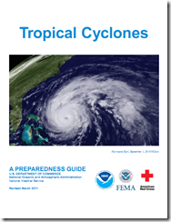
And finally, if you haven’t already downloaded the Tropical Cyclone Preparedness Guide, now would be an excellent time to do so. It is a short (12-page), easy to follow guide that will walk you through the basics of understanding (and surviving) hurricanes and tropical storms.
