# 8662
Live along the Atlantic or Gulf coastline long enough, and the odds say you’ll eventually be impacted by an Atlantic hurricane or tropical storm. As a native Floridian - I’ve seen more than a few - which is why I give hurricane preparedness a prominent place in this blog each year.
Well over 50 million Americans live in susceptible coastal areas, while further inland many more are susceptible to inland flooding and spinoff tornadoes.
From Escambia County Hurricane Preparedness Information
And while the tropical threat to Mexico, Central America, and the Caribbean islands is well known, a recent study (see Nature The poleward migration of the location of tropical cyclone maximum intensity) suggests the hurricane threat may be increasing for higher latitudes. This from NOAA News.
NOAA-led study: Tropical cyclone 'maximum intensity' is shifting toward poles
Researchers find that the average latitude where tropical cyclones achieve maximum intensity has been shifting poleward since 1980
May 14, 2014
Typhoon Francisco and Super Typhoon Lekima on October 23, 2013 as they tracked northwestward toward China and Japan. (Credit: Tim Olander and Rick Kohrs, SSEC/CIMSS/UW-Madison, based on Japan Meteorological Agency data.)
Over the past 30 years, the location where tropical cyclones reach maximum intensity has been shifting toward the poles in both the northern and southern hemispheres at a rate of about 35 miles, or one-half a degree of latitude, per decade according to a new study, The Poleward Migration of the Location of Tropical Cyclone Maximum Intensity, published tomorrow in Nature.
As tropical cyclones move into higher latitudes, some regions closer to the equator may experience reduced risk, while coastal populations and infrastructure poleward of the tropics may experience increased risk. With their devastating winds and flooding, tropical cyclones can especially endanger coastal cities not adequately prepared for them. Additionally, regions in the tropics that depend on cyclones' rainfall to help replenish water resources may be at risk for lower water availability as the storms migrate away from them.
All this week we’ll be talking about the different types of hurricane threats, and what you should be doing now to prepare for them.
While later this week we’ll look at hurricane winds, surge, and flooding, and preparedness today we’ll focus on some of the ways that this year’s hurricane forecasts will change.
Five prominent changes are described in a NOAA release called Update on NHC Products and Services for 2014 (PDF).
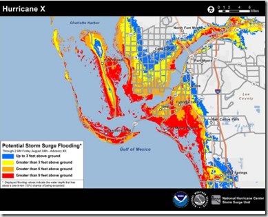
The biggest change will be the inclusion of a color-coded experimental Potential Storm Surge Flooding Map showing the locations that could be affected by storm surge based on their Sea, Lake and Overland Surges from Hurricanes (SLOSH) computer model.

We looked at this forecasting tool back in 2011 in Getting SLOSHed For Hurricane Season.
Other changes this year:
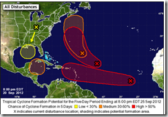
The Tropical Weather Outlook (TWO) and Graphical Tropical Weather Outlook (GTWO) will both be extended to a 5-day outlook. The TWO and GTWO products are issued at 2 a.m., 8 a.m., 2 p.m., and 8 p.m. Eastern Daylight Time.

While forecast tracking of Hurricanes has improved considerably over the years, less progress has been made in predicting intensities 12, 24, 48, and 72 hours out.
So gone this year will be the The Wind Speed Probability product which showed the likelihood that a tropical cyclone would be at any one of several different wind speed categories over the next three days.
The concern was people were basing their evacuation/preparation decisions on a model that the NHC describes as being accurate, but in some cases could provide `a highly misleading estimate of landfall intensity’.
A relief to all those who see `all-caps’ text messaging as `shouting’, the NHC will implement a more eye-friendly standard for their Tropical Weather Outlook and the Tropical Cyclone Discussion using mixed case, as well as with the full set of standard punctuation symbols. No formatting changes are planned for other NHC advisory products at this time.
And lastly, as a further indication that hurricane track forecasts continue to improve, the 2014 Tropical Cyclone forecast cone will be slightly smaller for 72 hours out, and beyond. Not a big change, but a hopeful trend.
When it comes to getting the latest information on hurricanes, your first stop should always be the National Hurricane Center in Miami, Florida. These are the real pros, and the only ones you should rely on to track and forecast the storm.
- Tropical storm watches will be issued when tropical storm conditions are possible along the coast within 48 hours.
- Tropical storm warnings will be issued when those conditions are expected within 36 hours. Similar increases in lead-time will apply to hurricane watches and warnings.
NOAA’s NWS National Hurricane Center in Miami also has a Facebook page, where you can keep up with the latest tropical developments.
The second official information source you should have bookmarked is your local Office of Emergency Management. Here you’ll be able to access local warnings, flood maps and evacuation information. To find your local one, you can Google or Yahoo search with your county/parish name and the words `Emergency Management’.
If you are on Twitter, you should also follow @FEMA, @CraigatFEMA, @NHC_Atlantic, @NHC_Pacific and @ReadyGov.
We all hope that the 2014 tropical season will be as non-eventful as last year, but no one can predict what may waltz up out of the tropics this summer.
As I wrote a week ago (see NOAA: 2014 Atlantic Hurricane Outlook), 1992 was a `quiet’ year for hurricanes – as long as you don’t count Category 5 hurricane Andrew . . .
Which is why preparedness – not hope - is your best insurance against an uncertain, and potentially dangerous, hurricane season.

