# 8679
For those born after 1960, it is probably hard to understand just how vulnerable we used to be to the unannounced arrival of hurricanes and tropical storms. Before then, we had no `eyes in the skies’ – weather satellites – to tell us if something was brewing far offshore, and tracking storms was pretty much hit and miss, based on ship’s reports.
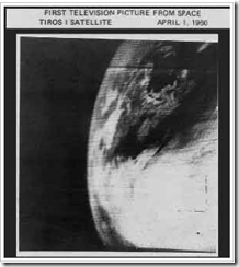
All that uncertainty began to change, when on April 1st 1960 Tiros I - the world's first weather satellite - was launched into Earth orbit from Cape Canaveral, Florida.
For the first time, we had a `god's eye view' of earth, and while the pictures were grainy, and the resolution laughable by today's standards, we could finally watch how and where hurricanes formed. It was a wondrous day for everyone, except possibly for members of the Flat Earth Society.
The first weather satellite photo from space.
It meant we were no longer solely dependent on ship's reports and Hurricane Hunter aircraft to know if disaster lay just beyond the horizon. It meant more than 12 hours warning to prepare for a storm. And it was a major step in unraveling the mysteries of cyclone genesis.
It would take time of course. The first satellite only produced about 1 picture an hour, and then, only during daylight hours. Infrared capability was added in later `birds’. For those with in interest in how `old school’ forecasting was accomplished, last year I wrote about a legend: Grady Norton: The First Hurricane Forecaster.
Three different views from space, taken May 26th, 2011 1345Z – NOAA
Today, our reconnaissance satellites can take 40 pictures an hour, and see right through the clouds and measure rainfall, winds and even sea water temperatures.Add in the power of supercomputers,ocean buoys, hurricane probes, and five decades of new knowledge, and the art of hurricane forecasting has improved tremendously over the past 50 years.
This year, forecasts will include even more information – particularly for coastal residents – as we discussed on Sunday. This year, the NHC will be issuing enhanced color-coded experimental Potential Storm Surge Flooding Maps showing the locations that could be affected by storm surge based on their (SLOSH) computer models.
Of course, all of the advances in forecasting technology are for naught if people don’t use this information to prepare for – and in some cases, get out of the way of – these storms.
Which is why tomorrow and Saturday Hurricane Preparedness Week will focus on what you need to do to get ready for the storm.
In the meantime, if you haven’t already, now would be a good time to download the updated Tropical Cyclone Preparedness Guide and to think about what hazards your home, and or business, might face if one of these storms pays a visit this summer or fall.


