
Crystal Beach, Tx after Hurricane Ike (2008) showing destructive force of storm surge
# 10,088
This is day two of 2015’s National Hurricane Preparedness Week and the focus today is on Storm Surge, often the biggest cause of death from these killer storms. While we usually worry most about the winds surrounding the eye of a hurricane, storm surge is more dependent on the contour of the coast, the storm’s angle of approach, and the forward speed of the storm.
Often the highest surge is well away from where the eye crosses the coastline, which can catch some coastal residents off guard.
This year the National Hurricane Center will be introducing a new experimental forecast product designed to warn coastal residents of areas where dangerous storm surges are expected. Full implementation of this product is not expected until 2017.
National Hurricane Center to issue storm surge watch and warning graphic
Beginning with the 2015 hurricane season, NOAA’s National Hurricane Center (NHC) will offer an experimental storm surge watch/warning graphic to highlight those areas along the Gulf and Atlantic coasts of the United States that have a significant risk of life-threatening inundation by storm surge from a tropical cyclone.
The new graphic is designed to introduce the concept of a watch or warning specific to the storm surge hazard. Storm surge is often the greatest threat to life and property from a tropical cyclone, and it can occur at different times and at different locations from a storm’s hazardous winds. In addition, while most coastal residents can remain in their homes and be safe from a tropical cyclone’s winds, evacuations are generally needed to keep people safe from storm surge. Having separate warnings for these two hazards should provide emergency managers, the media, and the general public better guidance on the hazards they face when tropical cyclones threaten.(Continue . . . )

Next stop, a short video from the NHC (National Hurricane Center), and a NHC description of storm surge, after which I’ll return with a bit more:
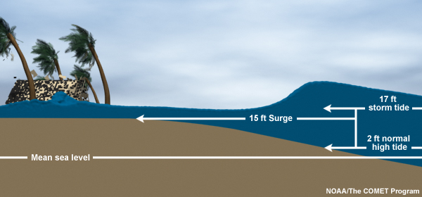
Storm Surge vs. Storm Tide
Storm surge is an abnormal rise of water generated by a storm, over and above the predicted astronomical tides. Storm surge should not be confused with storm tide, which is defined as the water level rise due to the combination of storm surge and the astronomical tide. This rise in water level can cause extreme flooding in coastal areas particularly when storm surge coincides with normal high tide, resulting in storm tides reaching up to 20 feet or more in some cases.

Storm Surge vs. Storm Tide

Back in 2011, in Getting SLOSHed For Hurricane Season I wrote about the Sea, Lake and Overland Surges from Hurricanes computer model that emergency planners use to plan for coastal evacuations. In order to know in advance how far inland a storm surge or tide will encroach, emergency planners run hundreds of SLOSH models for populated regions along the coast.

They vary the size, intensity, direction, and forward speed of hurricanes in the model in order to determine the worst case impact for each category of storm. Evacuation maps and routes are then generated using this information.
This evacuation map of Pinellas County (St. Petersburg-Clearwater) Florida shows that a storm even as low as a CAT 3 could temporarily cut the southern half of the county off from the north.

Of course much depends upon the speed, direction, and point of landfall of the storm, and so not all CAT 3 storms impacting this area would produce this dramatic of an effect.
Take it from someone who has experienced more than one of these storm surges first hand . . . if you are asked to evacuate by your local authorities, don’t hesitate.
Just do it.
For more information on the storm’s effects, and how you should prepare, check back every day this week and visit:
