# 10,027
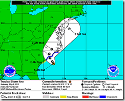
It’s still three weeks till the Atlantic Tropical Storm season officially kicks off (June 1st), but subtropical storm Ana transitioned into a full-fledged tropical storm overnight and ramped up its winds to a respectable 60 MPH sustained, as it slowly saunters off the Southeastern coastline.
Landfall should come Sunday morning, somewhere near the North/South Carolina boarder, but tropical storm force winds, heavy rains, and some coastal flooding are likely to begin to be felt today and tonight.
While not a particularly large or powerful storm, local interests should monitor the storm on the NHC website, and follow all instructions offered by their local Office of Emergency Management. If you are on Twitter, you should also follow @FEMA, @CraigatFEMA, @NHC_Atlantic, @NHC_Pacific and @ReadyGov.
This is the latest bulletin from the National Hurricane Center:
BULLETIN
TROPICAL STORM ANA ADVISORY NUMBER 6
NWS NATIONAL HURRICANE CENTER MIAMI FL AL012015
500 AM EDT SAT MAY 09 2015...ANA TRANSITIONS TO A TROPICAL STORM WHILE IT MOVES SLOWLY NORTH-NORTHWESTWARD TOWARD THE CAROLINAS...
SUMMARY OF 500 AM EDT...0900 UTC...INFORMATION
----------------------------------------------
LOCATION...32.4N 77.6W
ABOUT 105 MI...170 KM SSE OF CAPE FEAR NORTH CAROLINA
ABOUT 115 MI...190 KM SE OF MYRTLE BEACH SOUTH CAROLINA
MAXIMUM SUSTAINED WINDS...60 MPH...95 KM/H
PRESENT MOVEMENT...NNW OR 340 DEGREES AT 3 MPH...6 KM/H
MINIMUM CENTRAL PRESSURE...998 MB...29.47 INCHESWATCHES AND WARNINGS
--------------------
CHANGES WITH THIS ADVISORY:None.
SUMMARY OF WATCHES AND WARNINGS IN EFFECT:
A Tropical Storm Warning is in effect for...
* South Santee River South Carolina to Cape LookoutA Tropical Storm Watch is in effect for...
* Edisto Beach South Carolina to South of South Santee RiverA Tropical Storm Warning means that tropical storm conditions are
expected somewhere within the warning area, in this case within
12-24 hours.A Tropical Storm Watch means that tropical storm conditions are
possible within the watch area, in this case within 24 hours.Interests elsewhere in eastern North Carolina should monitor the
progress of Ana.For storm information specific to your area, including possible
inland watches and warnings, please monitor products issued by your
local National Weather Service forecast office.
We’ll be participating, as we do every year, in National Hurricane Preparedness Week later in the the month, but Ana’s early arrival serves to illustrate the value of always being prepared for the unexpected. If you haven’t already downloaded the updated Tropical Cyclone Preparedness Guide, now would be an excellent time to do so.

