# 4600
As a (former) paramedic, I’m used to thinking about and preparing for the `worst case scenario’. Hurricanes, plane crashes, chemical spills . . . you name it. It is part of the job description.
Thankfully, they don’t happen very often.
In fact, most of the extreme situations we trained for simply didn’t happen on my watch. But over the years, just about all of them have happened on somebody’s watch.
A few recent examples include:
Haitian Earthquake (2010)
Sichuan earthquake (2008)
Katrina (2005)
Indonesian Tsunami (2004)
World Trade Center (2001)
As disconcerting as it may be to think about, emergency planners and response agencies don’t have the luxury to ignore `worst-case scenarios’. It is their job to prepare for them.
Later today we’ll be getting the revised 2010 Atlantic Hurricane Outlook from NOAA, and most experts are anticipating that we’ll see a busy year.
While no one can predict months in advance where hurricanes will hit, or how strong they will be when they do, emergency planners do have their `worry list’; Heavily populated areas of the coastline that are at particularly high risk from major hurricanes.
The damage expected from a Category 4 or 5 storm is 100 times greater than that from a Category 1 Hurricane.
Since most people have never experienced a CAT 5 storm, or its aftermath, it might be useful to look at how NOAA describes its impact. This from the newly revised Saffir-Simpson Scale (emphasis mine):
Category 5
Winds (1 min sustained winds in mph and km/hr) 155MPH
Catastrophic damage will occur
People, livestock, and pets are at very high risk of injury or death from flying or falling debris, even if indoors in mobile homes or framed homes.
Almost complete destruction of all mobile homes will occur, regardless of age or construction.
A high percentage of frame homes will be destroyed, with total roof failure and wall collapse. Extensive damage to roof covers, windows, and doors will occur. Large amounts of windborne debris will be lofted into the air. Windborne debris damage will occur to nearly all unprotected windows and many protected windows.
Significant damage to wood roof commercial buildings will occur due to loss of roof sheathing. Complete collapse of many older metal buildings can occur. Most unreinforced masonry walls will fail which can lead to the collapse of the buildings. A high percentage of industrial buildings and low-rise apartment buildings will be destroyed.
Nearly all windows will be blown out of high-rise buildings resulting in falling glass, which will pose a threat for days to weeks after the storm.
Nearly all commercial signage, fences, and canopies will be destroyed.
Nearly all trees will be snapped or uprooted and power poles downed.Fallen trees and power poles will isolate residential areas.
Power outages will last for weeks to possibly months. Long-term water shortages will increase human suffering. Most of the area will be uninhabitable for weeks or months.
If this sounds extreme, it is.
But it is exactly what happened to Homestead, Florida in 1992 with Hurricane Andrew, and to the Mississippi Gulf coast in 1969 in the wake of Hurricane Camille.
And it doesn’t take an (admittedly) rare land falling CAT 5 storm to do incredible damage. Katrina was barely a CAT 3 when it devastated New Orleans.
From an insured loss standpoint, the 10 worst places for an extreme hurricane to strike are:
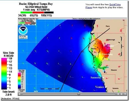
What you see below is a SLOSH Model (Sea, Lake, Overland, Surge, from Hurricanes) depicting a CAT 4 storm coming in just north of St Petersburg (Tarpon Springs), driving a wall of water up into Tampa Bay.
Some areas of St. Pete and Tampa would have 15-18 feet of water on top of them. And at the point where I snapped this image, the storm would be sitting just about on top of what ever is left of my home.
You can view the entire animation HERE.
Houston, Texas is another highly vulnerable area. Here is a 10 second SLOSH model for that community.
A couple of years ago the State of Florida held an exercise on a `worst-case’ imaginary hurricane; Hurricane Ono ( Think: “Oh No!”).
A CAT 5 storm that would come in at Miami, cross the state and exit around Tampa, re-intensify in the Gulf, and then strike Pensacola as a CAT 4.
You can read more about this scenario here.
This path is remarkably similar to the path of the Great Miami Hurricane of 1926, which killed hundreds in South Florida.
Hopefully, won’t see a `worst-case scenario’ this year.
But it will happen again. If not this year, perhaps next year, or the year after.
The Saffir-Simpson Scale description of a CAT 5’s damage is admittedly the worst-case scenario, but is worth remembering as you think about and prepare for this hurricane season. :
Power outages will last for weeks to possibly months. Long-term water shortages will increase human suffering. Most of the area will be uninhabitable for weeks or months.
Which is why it is imperative that people living in vulnerable areas heed evacuation warnings, that they prepare to weather the storm and it's aftermath . . . and that they take all of this very, very seriously.


