# 5752
Although the first two months of the 2011 Atlantic Hurricane season has seen a fair amount of activity, with the exception of a weak tropical storm (Don) that crossed the Texas coast in late July, the United States has been spared.
From mid-August on the tropical threat grows, and so we watch tropical waves as they come off the African coast with particular interest. Every hurricane season 100 or more of these systems move across the Atlantic, and some small percentage of those turn into tropical cyclones.
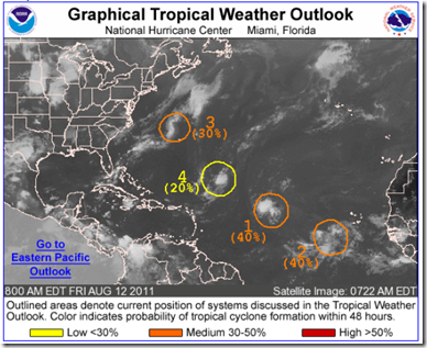
Today, two such systems are moving out of the Cape Verde basin – long known as the birth place for some of the the strongest, and longest lived hurricanes. Both have a medium chance of developing into a tropical cyclone.
The following comes from today’s 8am Tropical Weather Outlook from the NHC.
1. AN AREA OF LOW PRESSURE CENTERED ABOUT 1175 MILES EAST OF THE NORTHERN LEEWARD ISLANDS IS MOVING WEST-NORTHWESTWARD AT NEAR 20 MPH. SHOWERS AND THUNDERSTORMS HAVE BECOME A LITTLE BETTER ORGANIZED...AND ENVIRONMENTAL CONDITIONS ARE GRADUALLY BECOMING MORE CONDUCIVE FOR DEVELOPMENT. THIS SYSTEM HAS A MEDIUM CHANCE...40 PERCENT...OF BECOMING A TROPICAL CYCLONE DURING THE NEXT 48 HOURS.
Behind this system, and just recently moving off the coast of Africa, we have a 2nd Cape Verde disturbance.
2. A BROAD LOW PRESSURE SYSTEM LOCATED ABOUT 450 MILES SOUTHWEST OF THE SOUTHERN CAPE VERDE ISLANDS IS PRODUCING A LARGE AREA OF CLOUDINESS AND SCATTERED SHOWERS. ENVIRONMENTAL CONDITIONS ARE EXPECTED TO GRADUALLY BECOME MORE CONDUCIVE FOR DEVELOPMENT OVER THE NEXT SEVERAL DAYS AS IT MOVES WESTWARD AT 15 TO 20 MPH. THIS SYSTEM HAS A MEDIUM CHANCE...40 PERCENT...OF BECOMING A TROPICAL CYCLONE DURING THE NEXT 48 HOURS.
The NHC is also watching two other areas for possible development (# 3 & #4 on the map).
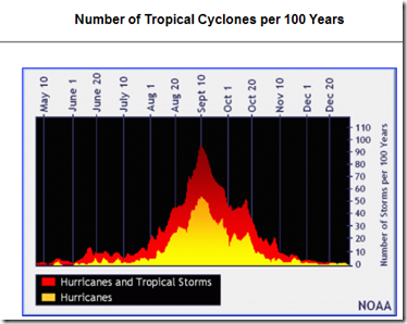
Whether any of these systems develop, or ever pose a threat to land, remains to be seen. But for the next 60-90 days the tropics will be at their most active, and so it makes sense to keep a weather eye on the horizon.
Photo Credit- NOAA
The National Hurricane Center website should always be your primary source of information, but if you are on Twitter, you should also follow @FEMA, @CraigatFEMA, @NHC_Atlantic, @NHC_Pacific and @ReadydotGov for the latest Emergency information.
And if you’ve not completed (or recently reviewed) your emergency plan and preparations, now would be an excellent time to do so.

