# 5925
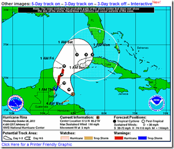
Hurricane Rina, a strong Category 2 storm may intensify further today as it moves slowly in the general direction of the Yucatan Peninsula.
Hurricane warnings are posted for the east coast of the Yucatan Peninsula North of Punta Gruesa to Cancun. Tropical storm warnings are posted along the coast from Chetumal to Punta Gruesa.
The latest advisory can be found at the National Hurricane Center’s website.
While the storm is expected to weaken a bit by the weekend, its path more than 72 hours down the road is less than certain, and the forecast currently puts most of south Florida in the 5-day cone.
The latest model runs place Rina - five days from now - as far north as Tampa Bay, and as far south as Havana, Cuba.
The majority of the models are clustered around the Florida Straits or the western tip of Cuba.
All of which means that interests from north Florida southward need to keep a weather eye out this weekend.
As always, the National Hurricane Center website should be your primary source of forecast information, but if you are on Twitter, you should also follow @FEMA, @CraigatFEMA, @NHC_Atlantic, @NHC_Pacific and @ReadydotGov for the latest Emergency information.

