# 6348
As a second generation Floridian, one who has spent roughly a quarter of his life living aboard boats, I have developed a deep and abiding respect for hurricanes and tropical storms.
My `first hurricane’ was the infamous Donna of 1960, which I rode out at the age of six in St. Petersburg, Florida. She put part of a large oak tree through our roof, but otherwise we came away unscathed.
In the years that followed I had brief but memorable encounters with several storms, including Betsy in 1965, the fringes of Abby and Gladys in 1968, Agnes in 1972 and Elena in 1985.
I also saw the devastation first-hand after Camille tore through Mississippi in 1969, and Katrina swamped New Orleans in 2005.
While hurricanes sometimes fail to live up to the pre-landfall hype, every once in awhile we get an Andrew, Camille, or Katrina, and they can exceed all expectations.
It may be hard for folks to believe it today, but as recently as the late 1950s - before weather satellites - hurricanes could get `lost’ . . . sometimes for hours or days . . . and could show up unexpectedly and with little warning.
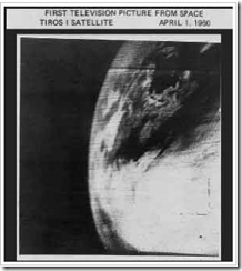
It was a very big deal, I can tell you, when on April 1st 1960 Tiros I - the world's first weather satellite - was launched into Earth orbit from Cape Canaveral, Florida.
Our view of our world changed, practically overnight. It was a wondrous day for everyone, except possibly for members of the Flat Earth Society.
The pictures were grainy, and the resolution laughable by today's standards, but for the first time we could watch from aloft and observe how and where hurricanes formed.
It meant we were no longer solely dependent on ship's reports and Hurricane Hunter aircraft to know if disaster lay just beyond the horizon.
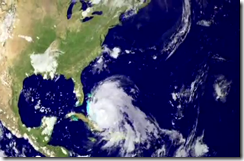
For some truly remarkable real-time satellite photos (and loops), the National Hurricane Center’s website maintains links to an extensive list of Latest Satellite Imagery.
But knowing a disaster is coming, and being prepared to deal with it, are two different things.
Which is why every year agencies like NOAA, NWS, FEMA, READY.GOV and organizations like the American Red Cross, work every year to get people to prepare. Not just for hurricanes, but for all manner of emergencies.
Today begins National Hurricane Preparedness Week, and as I do every year, I’ll be devoting a fair amount of blog space to this campaign.
This from the NHC website:
Hurricane Preparedness Week
Preparedness Week | Hazards | Watches & Warnings | Be Ready
History teaches that a lack of hurricane awareness and preparation are common threads among all major hurricane disasters. By knowing your vulnerability and what actions you should take, you can reduce the effects of a hurricane disaster.
Hurricane hazards come in many forms, including storm surge, heavy rainfall, inland flooding, high winds, tornadoes, and rip currents. The National Weather Service is responsible for protecting life and property through issuance of timely watches and warnings, but it is essential that your family be ready before a storm approaches. Furthermore, mariners should be aware of special safety precautions when confronted with a hurricane.
Download the Tropical Cyclone Preparedness Guide (PDF) or follow the links for more information. But remember, this is only a guide. The first and most important thing anyone should do when facing a hurricane threat is to use common sense.
National Hurricane Preparedness Week 2012 runs from May 27th through June 2nd.
To start off the campaign, NOAA has prepared this short PSA.
Every year I give hurricane preparedness a prominent place in this blog because for more than 50 million Americans living in coastal areas (and millions more in other countries), hurricanes and their byproducts (flooding, tornadoes, lightning) are probably their greatest natural disaster threat.
From Escambia County Hurricane Preparedness Information
While South Florida and the northern Gulf coast are at highest risk of direct hurricane impact, even those areas not shaded in – even hundreds of miles inland – can still feel the effects of a hurricane.
All this week we’ll be focusing on the specific hazards from these tropical systems, and how you can prepare your home, family, an business for their arrival.


