#13,575
When conditions are as favorable for tropical development as exist in the Gulf of Mexico right now - low shear, and very warm undisturbed water - tropical systems can intensify rapidly.
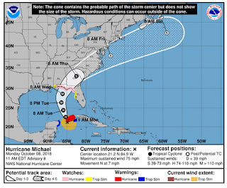
In just 24 hours, we've gone from expecting a Category 1 hurricane to now looking at possibly a CAT 3 (or better) storm.The 11am discussion now forecasts:
Storm surge - from just south of Tampa Bay north - is likely to be a major problem, as are (potentially) 120 MPH winds, and inland flooding. We may also see small tornadoes spin up - particularly north and east of the storm - over the next few days.
Given its size, and expected speed, Michael will likely deliver a significant blow to Florida, Georgia, the Carolinas, and possibly to parts of the mid-Atlantic region in the latter half of this week.
 |
| Link |
Anyone in the path of this storm should consider it the real deal, and make their preparations today and early tomorrow.
As a personal aside, even though I am just barely in the tropical storm watch area, I went out and gassed up my car this morning. While I was out, I saw people buying cases of water, batteries, and other supplies.After the debacle of empty shelves 5 days before Irma in 2017, people in central Florida are apparently paying better attention.
As always, when it comes to getting the latest information on hurricanes, your first stop should always be the National Hurricane Center in Miami, Florida. These are the real experts, and the only ones you should rely on to track and forecast the storm.
For some recent blogs on how to prepare for a hurricane, and deal with the aftermath, you may wish to revisit:If you are on Twitter, you should also follow @FEMA, @NHC_Atlantic, @NHC_Pacific and @ReadyGov.
#Natlprep: No Time Like The Present To Prepare
#NatlPrep: For A Brighter Day (and Night).
#NatlPrep: After The Storm Passes

