#14,082
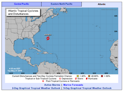
Although the 2019 Atlantic Hurricane season is still two weeks away, overnight the National Hurricane Center designated an area of disturbed weather Southwest of Bermuda a named subtropical Storm; Andrea.
This system is expected to be short-lived, and while an early arrival, doesn't really tell us much about what sort of season ahead to expect.On Thursday, May 23rd, NOAA will unveil their initial estimate of Atlantic tropical activity between June 1st and Nov. 30th. Activity may hinge upon the persistence (or lack, thereof) of a weak Pacific El Niño throughout the summer and into fall.
Regardless, it only takes one major hurricane to impact where you live or work to make for a very bad day, week, or even month. Whatever the outlook, everyone should prepare as if the worst could happen.The brief NHC discussion of Andrea follows:
DISCUSSION AND OUTLOOK
----------------------
At 500 AM AST (0900 UTC), the center of Subtropical Storm Andrea was located near latitude 30.0 North, longitude 69.0 West. The storm is moving toward the north near 6 mph (9 km/h), and that general motion is expected to continue this morning.
A turn toward the northeast is forecast by this afternoon, followed by an eastward motion by late tonight and Wednesday. On the forecast track, the center of Andrea is expected to remain southwest and south of Bermuda during the next day or two.
Maximum sustained winds are near 40 mph (65 km/h) with higher gusts. Little change in strength is forecast today, followed by weakening late tonight. Andrea is expected to dissipate on Wednesday. Winds of 40 mph extend outward up to 60 miles (95 km) from the center. The estimated minimum central pressure is 1007 mb (29.74 inches).
HAZARDS AFFECTING LAND
----------------------
None.