
#12,276
Although the 5am forecast track from the National Hurricane Center shows the core of Hurricane Dorian staying off the east coast of Florida, the margin for error 2 and 3 days out (as shown by the cone of uncertainty) is wide enough to allow for a Florida landfall.
The current thinking by the NHC is that Dorian will slowly continue west towards South Florida for the next 2 days - become nearly stationary over the Bahamas - before turning north.The rub is even if the storm follows the forecast, it will move uncomfortably close to South Florida. Close enough to necessitate the issuing of Tropical Storm Warnings this morning North of Deerfield Beach to Sebastian Inlet.
This from the NHC 5am Discussion:
The westward shift of the NHC track within the first 48 hours necessitates the change from a Tropical Storm Watch to a Tropical Storm Warning for a portion of the Florida east coast. Although the official track forecast does not show landfall, users should not focus on the exact track since a Florida landfall is still a distinct possibility.The problem is the model guidance - which are in pretty good agreement through the next 48 hours - begins to diverge substantially after that time. A few models (0Z CMC Model Link) this morning take Dorian either very close to, or even into, the Florida peninsula by day 3, while most others keep it out to sea.
Some models are - on average - better than others. But all of them, at one time or another, have shone. And with 10 million Floridians in Dorian's path, the stakes couldn't be higher.For the NHC and Emergency Management offices across the state, the next 24-48 hours are going to long and very difficult, as a decision must be made whether or not to issue hurricane and evacuation orders along the coastline.
If they do it, and the storm turns as expected, a million people could be forced to evacuate unnecessarily. If they wait, and the storm doesn't turn, millions of people could have very little warning.
Be very glad this isn't your decision to make. I know I am.
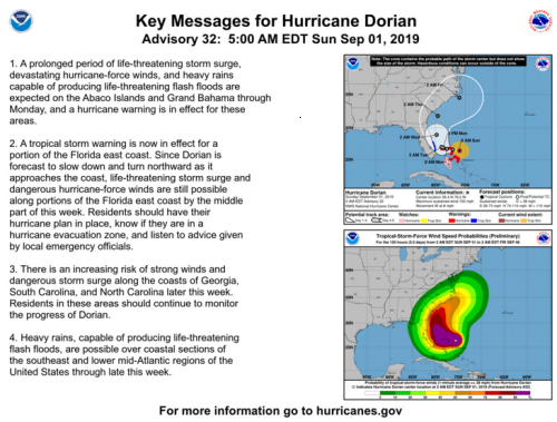
The upshot to all of this is, for residents along the east coast from Miami to Jacksonville (and points north), it is too soon to celebrate and they should remain prepared to act with purpose if the forecast changes over the next 24 to 48 hours.This morning's Key Messages from the NHC :
The next full advisory from the NHC will come at 11am, followed by 5pm and 11pm.