
Mariner’s Poem On Hurricanes
June too soon.
July stand by.
August look out you must.
September remember.
October all over.
- Published in “Weather Lore” by R. Inwards in 1898
#16,157
With roughly a million residents of Southeastern Louisiana - including the City of New Orleans - lying in darkness and ruin following the landfall of CAT 4 Hurricane Ida, it is sobering to remember that we aren't even at the historic peak of hurricane season (normally Sept 10th) and there are probably 8 active weeks still ahead.

With the overnight addition of Tropical Storm Larry in the far eastern Atlantic, we are now on our 12th named storm of the 2021 season, with 4 of those becoming hurricanes, and two of them Major.
Normally, by Sept 1st, we'd be on our 2nd hurricane, and only our 5th named storm (see chart below).

But the tropical Atlantic goes through a multidecadal cycle (AMO) of heating and cooling, which greatly affects tropical storm formation (see chart below). During the 1970s, 1980s, and into the 1990s - a time of great expansion of coastal building, particularly along the Gulf Coast - we saw a slump in the number, and intensity of Atlantic hurricanes.
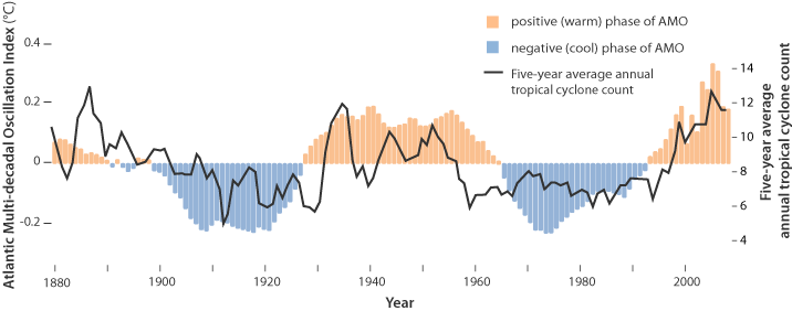
For the past 20 years we've been in an up-cycle, not unlike the 3-decades between 1926 and 1970, which produced some of the most memorable weather disasters of the 20th century. How long this phase will last, and how much amplitude it might achieve, is unknown.
But this is a known, and repeatable, pattern and it likely has another decade to run.
While the good news is, there are no apparent immediate tropical threats to the Caribbean or to the United States, that will likely change over the next week or two, as climatological conditions reach their zenith in September for tropical development in the Atlantic basin.
Hopefully most of these storms will remain out to sea, but if you haven't fully prepared for hurricane season, the long Labor Day Weekend provides an excellent opportunity to rectify that omission.
Early season storms tend to form in the Gulf of Mexico or Caribbean, but as ocean temperatures rise late in summer, and winds aloft become more favorable, hurricanes tend to form farther to the east, giving them more time grow before encountering land (see below).
Credit NOAA’s Tropical Cyclone Climatology page.

For more than 50 million Americans living in coastal areas, hurricanes and their byproducts (flooding, tornadoes, lightning) are probably their greatest natural disaster threat.

By early October, the hurricane spawning grounds retract again (see below), 2018's Category 5 Hurricane Michael, 2012's Superstorm Sandy, and 2005's Hurricane Wilma all remind us that the danger remains.
 |
| Credit NOAA’s Tropical Cyclone Climatology page. |

Hurricane Preparedness Week: Day 5 - Strengthen Your Home
Hurricane Preparedness Week: Day 4 - Get An Insurance Check-up
Hurricane Preparedness Week: Day 3 - Assemble Disaster Supplies
Hurricane Preparedness Week: Day 2 - Develop An Evacuation Plan
National Hurricane Preparedness Week: Day 1 - Determine Your Risk
Hurricane Prep: Some Simple Off-The-Shelf Solar Solutions For Power Outages