#17,969
Today (March 27th) is the 60th anniversary of the Great Alaskan earthquake of 1964, and that state will test its tsunami warning system (see announcement below) later today as part of National Tsunami Awareness Week.
Officials to Test Tsunami Warning System in Alaska March 27, 2024
On Wednesday, March 27th at approximately 10:20 am, the National Weather Service, Alaska Division of Homeland Security and Emergency Management, and the Alaska Broadcasters Association will conduct a test of the Alaska tsunami warning system as a part of tsunami preparedness week in Alaska. The test will be broadcast on radio and television stations and the broadcast will state that it is only a test. Some communities may activate their sirens. NOAA Weather Radio listeners will hear a tone alert followed by a test message. The test will not be sent to cellphones via the Wireless Emergency Alert (WEA) system, although in an actual Tsunami Warning this system would be used.Alaska's 1964 earthquake produced significant tsunami effects both locally, and thousands of miles away, killing 5 in Oregon and 13 in California. March 11th was also the 13th anniversary of Japan's 2011 Tōhoku Earthquake & Tsunami which killed in excess of 15,000 people.
After the test, we invite you to provide feedback at www.ready.alaska.gov.
Once again, a tsunami warning system test will be conducted on Wednesday, March 27th at approximately 10:20 am. The test will be canceled in the event of any significant seismic activity.

Tsunamis are usually generated by large earthquakes, or underwater volcanic explosions, although massive undersea avalanches - and in rare instances - an asteroid strike can generate one.
The west coast of North America, since it is vulnerable to tsunamis generated by seismic events in Japan, Alaska, and throughout the Pacific rim - including the long expected `big one' off the Pacific Northwest's coast (see Just A Matter Of Time) - is viewed as the most `at risk' region of the continental United States and Canada.
In 2013 the USGS released a report detailing the likely West Coast impact of a tsunami generated by a 9.1 Alaskan earthquake – and the numbers are sobering. From the USGS news release Experts Team Up on Tsunami Resilience in California:
In this scenario approximately 750,000 people would need to be evacuated, with 90,000 of those being tourists and visitors. Additionally, one-third of the boats in California's marinas could be damaged or completely sunk, resulting in $700 million in losses. It was concluded that neither of California's nuclear power plants would likely be damaged by this particular event.
The study (link) also estimates damage to marinas, businesses and homes range between $3.5 billion and $6 billion, and as many as 8,500 could be left homeless.
But, as we've discussed previously (see The Caribbean’s Hidden Tsunami Potential (Revisited), both the Caribbean and the Atlantic also have a history of seismic activity, making our East and Gulf Coast vulnerable to tidal waves as well.In 1995, Montserrat's previously dormant Soufrière Hills volcano sprang to life, destroying the capital city of Plymouth, and rendering half the island uninhabitable.
In 2013 the USGS warned the Earthquake/Tsunami Hazard in Caribbean Higher Than Previously Thought, stating `Enough strain may be currently stored in an earthquake zone near the island of Guadeloupe to cause a magnitude 8 or larger earthquake and subsequent tsunami in the Caribbean’
A list of known or suspected Atlantic Tsunamis includes:
- November 1, 1755 - Lisbon, Portugal
- October 11, 1918 - Puerto Rico
- November 18, 1929 - Newfoundland
- August 4, 1946 - Dominican Republic
- August 18, 1946 - Dominican Republic
- November 14, 1840 - Great Swell on the Delaware River
- November 17, 1872 - Maine
- January 9, 1926 - Maine
- May 19, 1964 - Northeast USA

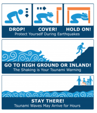
Knowing your local threats, whether they be tsunamis, forest fires, floods, earthquakes or hurricanes . . . and then becoming prepared to deal with them, will provide you and your family the best safety insurance available.
For information on how to prepare for a tsunami, and how to react to an imminent threat, you should visit https://www.tsunamizone.org/

For help in getting better prepared for a variety of emergencies, I would invite you to visit:
FEMA http://www.fema.gov/index.shtm
READY.GOV http://www.ready.gov/
AMERICAN RED CROSS http://www.redcross.org/