
#18,312
Yesterday, in #Natlprep: Watching The Gulf of Mexico, we looked at the potential development of a tropical system in the CAG (Central American Gyre), and the need for residents from Louisiana to Florida to to monitor the threat.
While a closed system has yet to form, just about all of the computer models are forecasting a significant hurricane in the eastern Gulf of Mexico within 24-48 hours from now.
Because this system is expected for move north rapidly, and has the potential to intensify quickly, the National Hurricane center - as of 11 am EDT - has begun issuing advisories.
At this time, the ultimate track and intensity at landfall, are based on limited data, and are subject to change.
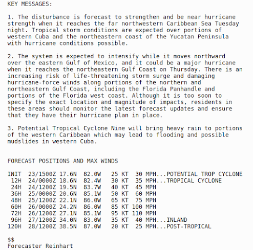
The NHC's discussion at 11 am reads, in part:
With landfall forecast on Thursday, and its exact path still undetermined, there may only be a couple of days for people to prepare and/or evacuate. If you live anywhere in Florida, or Georgia, you should be reviewing your plans, and your options now.
Since I live just on the eastern edge of the cone - and impacts can occur well outside that cone - I'll be preparing over the next couple of days, in case I am forced to evacuate.
Hurricane reconnaissance aircraft are scheduled to make multiple visits to this brewing system over the next 24 hours, and we should have much better idea about where it will go 24 hours from now.
Stay tuned.