# 4479
As a second generation Floridian, one who has spent roughly a quarter of his life living aboard boats, I naturally have a deep and abiding interest in hurricanes and hurricane forecasting.
Over the years I’ve ridden through my share of tropical storms, mostly on land, but occasionally aboard one of my boats. I’ve luckily been spared dealing first-hand with any of the truly monstrous storms, although a number remain `memorable’.
I was in Pass Christian, Mississippi shortly after Camille passed through, and helped retrieve my brother’s belongings from a devastated New Orleans in the wake of Katrina.
And my `first hurricane’ was the infamous Donna of 1960, which I rode out in St. Petersburg, Florida.
My respect for these storms is well rooted.
Hurricane Forecasting . . . particularly months in advance of the opening of Hurricane season. . . is an extremely complex and inexact science. The global dynamics of climate and weather are only slowly being unraveled, and the sheer amount of data that must be crunched is staggering.
Still . . . we learn by trying . . . even if at the start, success is elusive.
Since the mid-1980s the Tropical Meteorology Project at the University of Colorado – headed by Dr. William Gray - has issued seasonal hurricane forecasts, with varying degrees of success.
Some years, they come pretty close. Other years, not so much.
But each year, they learn more (even from forecasts that didn’t pan out), and in time . . . hopefully . . . long range hurricane forecasting will improve.
Yesterday, Gray’s team issued their (43 page PDF) April Update to the 2010 forecast. Their findings are summarized below:
We continue to foresee above-average activity for the 2010 Atlantic hurricane season. We have increased our seasonal forecast from the mid-point of our initial early December prediction due to a combination of anomalous warming of Atlantic tropical sea surface temperatures and a more confident view that the current El Niño will weaken.We anticipate an above-average probability of United States and Caribbean major hurricane landfall.
(as of 7 April 2010)
For those of us of a certain age, who grew up along the Gulf or Atlantic coasts before the advent of weather satellites, the technology we have at hand today is truly remarkable.
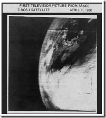
It was a very big deal, I can tell you, when on April 1st 1960 Tiros I - the world's first weather satellite - was launched into Earth orbit from Cape Canaveral, Florida.
Prior to that time we relied on ship’s reports and it wasn’t uncommon for Hurricanes to arrive with little notice or to get temporarily `lost’ at sea.
For the first time, we had a `god's eye view' of earth. Regions of our globe where once cartographers could only inscribe "Here there be Dragons' could be watched 24 hours a day.
Our view of our world changed, practically overnight.
It was a wondrous day for everyone, except possibly for members of the Flat Earth Society.
Sure the pictures were grainy, and the resolution laughable by today's standards, but for the first time we could watch from aloft and observe how and where hurricanes formed.
I was six years old. And I remember it like it was yesterday.
It meant we were no longer solely dependent on ship's reports and Hurricane Hunter aircraft to know if disaster lay just beyond the horizon.
It meant more than 12 hours warning to prepare for a storm.
TIROS 1 could take and transmit about 1 picture an hour, and only during daylight hours. Infrared capability was added to later `birds'. Today, our reconnaissance satellites can take 40 pictures an hour, and see right through the clouds and measure rainfall, winds and even sea water temperatures.
As a result, hurricane forecasting has improved tremendously over the past 50 years.
Yesterday’s forecast from the Tropical Meteorology Project is an excellent reminder of the value of scientific research, awareness, and preparedness.
This year, National Hurricane Preparedness week will be the last week of May. The following comes from the National Hurricane Center in Miami.
History teaches us that a lack of hurricane awareness and preparation are common threads among all major hurricane disasters. By knowing your vulnerability and what actions you should take, you can reduce the effects of a hurricane disaster. Hurricane Preparedness Week during 2010 will be held May 23rd through May 29th.

The goal of this Hurricane Preparedness Web site is to inform the public about the hurricane hazards and provide knowledge which can be used to take ACTION. This information can be used to save lives at work, home, while on the road, or on the water.
Hurricane hazards come in many forms: storm surge, high winds, tornadoes, and flooding. This means it is important for your family to have a plan that includes all of these hazards. Look carefully at the safety actions associated with each type of hurricane hazard and prepare your family disaster plan accordingly. But remember this is only a guide. The first and most important thing anyone should do when facing a hurricane threat is to use common sense.
You should be able to answer the following questions before a hurricane threatens:
What are the Hurricane Hazards?
What does it mean to you?
What actions should you take to be prepared?
Download the Hurricane Preparedness Week Poster (2009 version)
High Resolution Poster (1 MB PDF)


