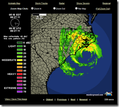
Irene looking a little ragged this morning
# 5789
For hurricanes, life is short and environmental threats to their existence are many.
It takes the right balance of environmental factors; low wind shear, warm waters to traverse and feed from, little or no interaction with land masses, and abundant moist tropical air to keep them going full tilt.
Take away, or reduce any of these vital components, and even powerful storms can quickly lose strength or fall apart altogether.
Irene, which was forecast to be a major (Cat 3) hurricane at landfall only 24 hours ago, has instead weakened overnight into a strong CAT 1 storm, with sustained winds of 90 MPH and higher gusts.
Of course, even at CAT 1 strength, Irene is not something to trifle with. She is still capable of producing a serious amount of damage, particularly from storm surge, so those in her path should not let their guard down.
But her impact is likely to be less than originally feared.
From the 5am NHC discussion:
LAND INTERACTION...DRY AIR ENTRAINMENT...AND INCREASING VERTICALWIND SHEAR SHOULD CAUSE IRENE TO WEAKEN AS IT MOVES ALONG THE U.S. EAST COAST. HOWEVER...THE CYCLONE IS EXPECTED TO REMAIN A HURRICANE WITH A VERY LARGE WIND FIELD UNTIL AFTER LANDFALL IN NEW ENGLAND. EXTRATROPICAL TRANSITION SHOULD OCCUR AFTER THE NEW ENGLAND LANDFALL...WITH IRENE GRADUALLY WEAKENING FROM 48-120 HR.
As I’ve mentioned in the past, the National Hurricane Center’s confidence in their intensity forecasting is less than in their forecast tracks.
The science is improving, but the number of constantly changing variables involved is absolutely staggering, and so storm intensity remains difficult to predict.
The conditions supporting a stronger Irene appeared to be in place.
She was far enough from land as to suffer little interference, the waters she was passing over were still relatively warm, and wind shear – although beginning to increase - had been low for the past several days.
But it appears that Irene has been weakened by the entrainment of drier air, pulled into the storm from the west.
While there may be some who will claim the NHC overstated the dangers, and in doing so disrupted the lives of millions of people this weekend, the truth is this storm could easily have gone the other way, and become stronger.
And when it is your job to provide 48 hours warning of what could be a major threat, you can’t weasel-word your warnings just to give yourself a convenient `out’.
The conditions were there to keep Irene a major storm at landfall, and so with lives at stake, the only prudent thing was to assume that could happen.
A situation not so dissimilar to what public health officials faced a little over 2 years ago when a novel influenza virus emerged, and began spreading rapidly around the globe.
Despite many unknowns, the conditions were in place to support the declaration of a pandemic. Even though the World Health Organization stated the severity was impossible to predict, they were forced to assume the worst, and plan accordingly.
As with the NHC warnings on Irene, it was the right thing to do.
The fact that the pandemic proved less severe than first thought was pure luck. The next time, we may not be so fortunate.
Sadly, many people who ride through Irene this weekend may decide that hurricanes aren’t so bad after all. They will think they’ve gone through a major storm, when they really haven’t, and may fail to listen to officials and take prudent steps the next time a storm threatens.
Just like the millions of people who now believe that another flu pandemic isn’t anything to worry about, since the last one was so mild.
Since past performance is no guarantee of future results, either assumption could prove disastrous down the road.
The bottom line: Even if we are lucky enough to dodge a bullet today . . .
We shouldn’t assume ourselves to be bulletproof tomorrow.
