#15,436
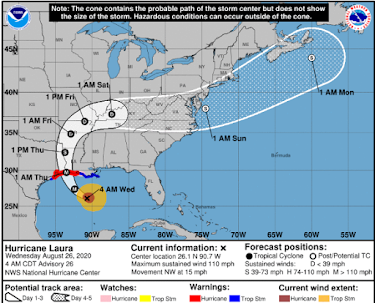
Even when it was still a tropical storm south of Cuba, the signs were all there indicating that Laura would become an intense hurricane once it entered the Gulf of Mexico. Now, with less than 24 hours until expected landfall (1 am Thurs CST), Laura is rapidly meeting those expectations.
The headlines from the National Hurricane Center's 5 am advisory are:
...LAURA EXPECTED TO RAPIDLY STRENGTHEN TO A CATEGORY 4 HURRICANE... ...FORECAST TO PRODUCE A LIFE-THREATENING STORM SURGE, EXTREME WINDS, AND FLASH FLOODING OVER EASTERN TEXAS AND LOUISIANA LATER TODAY...While the greatest impacts are expected along the Texas and Louisiana coast, this storm will have `legs', and those living and working many hundreds of miles inland will likely experience flooding, storms, and possibly even tornadoes.
Some of the impacts may extend as far as to the mid-Atlantic states, as the remnants or Laura are expected to emerge over water and gain strength early next week as an extra-tropical storm.
For now heavily populated Houston is forecast to remain on the weaker (left) side of the storm, but it is solidly inside the Hurricane warning area, and even the weak side of a CAT 4 hurricane can be formidable. No one in the warned areas should take this storm lightly.
Key Messages this morning from the NHC:
Storm surges, particularly to the right of where Laura makes landfall, are expected to be significant and life-threatening, with heights reaching 10 to 15 feet in some regions.
The National Weather Service at Sabine Pass has issued the following grim assessment of potential impacts from the storm:
POTENTIAL IMPACTS: Devastating to Catastrophic
- Structural damage to sturdy buildings, some with complete roof and wall failures. Complete destruction of mobile homes. Damage greatly accentuated by large airborne projectiles. Locations may be uninhabitable for weeks or months.
- Numerous large trees snapped or uprooted along with fences and roadway signs blown over.
- Many roads impassable from large debris, and more within urban or heavily wooded places. Many bridges and access routes impassable.
- Widespread power and communications outages.
Laura is unlikely to be the last major hurricane to threaten a U.S. landfall in this record setting 2020 hurricane season, and no one - from Texas to Maine - should feel immune.


