
Mariner’s Poem On Hurricanes
June too soon.
July stand by.
August look out you must.
September remember.
October all over.
- Published in “Weather Lore” by R. Inwards in 1898
#16,798
Two days ago the National Hurricane Center announced that the remnants of Hurricane Agatha from the eastern Pacific had a 40% chance of redevelopment after it crossed Central America into the Gulf of Mexico.
Today, on the opening day of the 2022 Hurricane season, they've upped that forecast to 80%, and are forecasting this developing system to move towards the Florida coast this weekend (probably as weak tropical depression or tropical storm).

While this is unlikely to become a big weather event, it is a reminder that Hurricane season is once again upon us, and that over the next few months storms will become stronger and more frequent. This year NOAA has (once again) predicted an above-average tropical season.
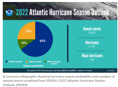
While they can't tell us where storms will make landfall, or how destructive they will be, early indications (La Niña conditions continuing in the Pacific and above-average sea surface temperatures in the North Atlantic) suggest a busy season ahead.
June Climatology
Although June isn't known for producing the kind of major, long-track hurricanes commonly seen in August-September-October, it isn't devoid of tropical threats either. When early storms do form, they are most likely to do so over the warm, relatively shallow waters of the the Gulf of Mexico and western Caribbean.
Further out to sea the Atlantic waters are generally too cold, and the winds and Saharan dust conditions aloft too unfavorable, to promote much in the way of long-track storm development.
But those conditions gradually change as the summer progresses.
June hurricanes have a reputation for being mild, short-lived, and less dangerous. But there have been some notable exceptions.
- Hurricane Audrey in 1957 was the only June storm in modern history known to reach CAT 4 strength, and it claimed 550 lives after it made landfall in eastern Texas and western Louisiana
- Category 1 Hurricane Agnes (1972), caused relatively little damage when it made landfall in Florida, but caused extensive inland flooding several days later in the Mid-Atlantic states, claiming 113 lives in New York and Pennsylvania.
- Slow moving tropical storm Allison - in June of 2001 – proved more than deadly producing 55 fatalities and causing in excess of $9 billion in damage to Southeast Texas - primarily due to its torrential rains.
- In 2010 Hurricane Alex – a strong CAT 2 hurricane – slammed into Mexican state of Tamaulipas after intensifying to hurricane strength on June 29th.

While generally weaker than later season storms, June hurricanes can develop quickly, sometimes providing coastal residents with less than a day's warning. Which is one of the reasons why preparing in advance - instead of waiting for a storm to form - is advised.
So if you haven't done so already, plan a visit to NOAA's National Hurricane Preparedness web page, and decide what you need to do now to keep you, your family, and your property safe during the coming tropical season.
While this blog, and many other internet sources (I follow Mark Sudduth's Hurricane Track, and Mike's Weather page), will cover this year's hurricane season. your primary source of forecast information should always be the National Hurricane Center in Miami, Florida.
These are the real experts, and the only ones you should rely on to track and forecast the storm.
If you are on Twitter, you should also follow @FEMA, @NHC_Atlantic, @NHC_Pacific and @ReadyGov and of course take direction from your local Emergency Management Office.