Showing posts with label Iceland. Show all posts

Wednesday, August 20, 2014

Barðarbunga Update & Webcams

image

Source Icelandic Met Office 


# 8977


Two days ago, in Iceland: Watching Bárðarbunga,  I wrote about the swarm of (mostly small) earthquakes close to Iceland’s second tallest volcano, and the raising of the aviation warning status for the volcano to Orange. Monday morning saw the largest quake – an M4.5 – but since then well over a thousand smaller quakes have continued to rumble.


Yesterday, local authorities – out of an abundance of caution - ordered the evacuation of large areas north of the volcano (see Icelandic Review Alert: Area North of Bárðarbunga Volcano Evacuated), although there are currently no signs of an eruption from the glacier-covered volcano.


While  the kind of constant low-level rumbling being detected beneath this volcano often portends an eruption, we’ve seen similar cases where the mountain simply quiets down after a period of time.  Even if there is an eruption, it is impossible to know how big of an event it will be.


Nevertheless, Europe and the airline industry – both which was severely impacted by the eruption of Eyjafjallajökull in 2010 – are monitoring these seismic events carefully.  


The latest update from the Icelandic Met Office was written last night.


A summary of seismic activity, written Tuesday evening 19th August 2014 at 20:00

20.8.2014

Around 1.000 small earthquakes were detected in the Bárðarbunga region from midnight (18/19) until Tuesday evening 19th August at 20:00. All of them were smaller than magnitude 3 and most were located in the cluster east of Bárðarbunga.


While the northern cluster close to Kistufell has calmed down significantly following the M4.5 earthquake on early Monday morning, event rates in the eastern cluster are still high. Similar to recent days, two pulses of comparably strong seismic activity have been measured between 04:00 and 08:00 this morning, as well as 16:00 and 18:30 in the afternoon. The cluster east of Bárðarbunga continued to slowly migrate northeastwards today. Events are still located at around 5-12 km depths, no signs of upwards migration has been seen so far.


Below is a summary map of all manually revised earthquakes since the onset of the swarm, which illustrates the migration of earthquake activity during the last days. Earthquakes in the map are colourcoded by time, dark blue dots show the onset of the swarm on Saturday, orange dots Tuesday's events until 19:00, light blue and yellow are the days in between. The time scale is days since the onset of the swarm.

Map by Gunnar B. Guðmundsson, Icelandic Meteorological Office.

The following update – dated August 20th – comes from Iceland’s Civil Protection Agency.


Summary in English

Last night the National Crisis Coordination Centre was fully activated after a decision was taken to evacuate the highlands north of Dyngjujökull (part of Vatnajökull glacier). The area is now closed and has been evacuated. These actions were taken following seismic activity around the Bardarbunga caldera in the last few days. The area that has now been closed is both large in size and unpopulated  There are still no signs of eruption but these security measures have been taken since it would not be possible to evacuate the area in time should a sub-glacial outburst flood occur from Vatnajökull as a result of an eruption.


At 03.00 the area had been evacuated. A map of the closed area is available at the website of the Icelandic Road and Coastal Administration: http://www.vegagerdin.is/media/umferd-og-faerd/Halendi.pdf In the northwestern part of Vatnajökull glacier the seismic activity is stable, with the main area being northeast of Bardarbunga. Over 300 earthquakes have been detected since midnight. The strongest event was of the magnitude 3.0. Another event happened inside the Bardarbunga caldera and was of the magnitude 2.7.

 
Today The Coast guard airplane, TF SIF, will make a surveillance flight over the area with scientists and representatives of the Civil Protection, if weather conditions allow. Police and ISAR units will enforce the closure of the area. The situation will continue to be closely monitored.


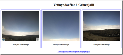
While there is little to see right now, three webcams have been placed around the volcano, which will provide live pictures if anything happens on the glacier. 
image

Monday, August 18, 2014

Iceland: Watching Bárðarbunga

image

Credit Icelandic Met Office


# 8967


Over the past 48 hours more than 1,000 (mostly small) earthquakes have been recorded very near Iceland’s largest active volcano and the Icelandic Met Office has raised the aviation alert status for Bárðarbunga  to Orange.   While an eruption is by no means certain, Bárðarbunga has an impressive geologic history, making this swarm worth keeping an eye on.


image


First the latest update from the Icelandic Met Office, then I’ll be back with a bit more.


  • Note

    Intense earthquake swarm continues at Barðarbunga. Presently there are no signs of magma moving to the surface.

Bárðarbunga, Vatnajökull ice-cap, in 1996.


Seismic activity at Bárðarbunga persists

18.8.2014

The intense seismic activity that started on 16 of August at Bárðarbunga persists. Very strong indications of ongoing magma movement, in connection with dyke intrusion, is corroborated by GPS measurements. There are currently two swarms: one to the E of Bárðarbunga caldera and one at the edge of Dyngjujökull just E of Kistufell. At 2.37 am on the 18th a strong earthquake (M4) was located in the Kistufell swarm.

This is the strongest earthquake measured in the region since 1996. As evidence of magma movement shallower than 10 km implies increased potential of a volcanic eruption, the Bárðarbunga aviation color code has been changed to orange. Presently there are no signs of eruption, but it cannot be excluded that the current activity will result in an explosive subglacial eruption, leading to an outburst flood (jökulhlaup) and ash emission. The situation is monitored closely.


You can read earlier dispatches going back 2 days from the Icelandic Met office at these links:

Activity in Bárðarbunga volcano

Earthquake swarm by Bárðarbunga volcano


There is no way of knowing at this time whether Bárðarbunga will erupt, or if it does, how big of an impact it would have.  A major eruption, while possible, is not necessarily the most likely scenario.


Roughly 8500 years ago this system did spew forth one of the largest known lava flows of the Holocene (present) era. But the volcano is located in a remote area - far from any large cities - and its biggest threat today may well be from floods due to melting of its thick glacial cap.


But we do know that occasionally Icelandic volcanoes have produced significant disruptions – not only locally – but also on a more international scale.


In the spring of 2010, the relatively small eruption of Iceland’s Eyjafjallajökull volcano sent thick plumes of ash into the atmosphere, closing many air corridors in Europe and disrupting travel for 6 days, illustrating just how vulnerable our modern world still remains to geologic events.  


An estimated 100,000 flights were affected, at a cost of over 1.7 billion dollars.  That said, not every volcanic eruption produces large ash plumes. 


In response to the impact of  Eyjafjallajökull  the UK’s National Risk Register For Civil Emergencies – essentially a short list of disaster scenarios (man-made & natural) that the Cabinet Office believe to be genuine threats – added volcanic eruptions in 2013. 


This despite the fact that there are no active volcanoes in the UK or Ireland.


Their concern stems from the impact of volcanic eruptions outside of their country – most notably, in Iceland. Specifically they cite:


Severe effusive (gas-rich) volcanic eruptions abroad – The 2010 eruption of the Eyjafjallajökull volcano in Iceland showed some of the consequences that a volcanic eruption abroad can have on the UK and its citizens. Following consultation with geological and meteorological experts about the potential risks the UK faces from volcanic eruptions in Iceland or elsewhere, the assessment is that there are two main kinds of risk from volcanic eruptions.

The first is an ash-emitting eruption, similar to that in 2010.

The second, which is slightly less likely than an ash-emitting eruption, but which could have widespread impacts on health, agriculture and transport, is an effusive-style eruption on the scale of the 1783–84 Laki eruption in Iceland. This second type of eruption is now one of the highest priority risks in the NRA and the NRR.


For those not familiar with the 1783 event –in that year the Craters of Laki in Iceland erupted and over the next 8 months spewed immense clouds of clouds of deadly hydrofluoric acid & sulphur dioxide, killing over half of Iceland’s livestock and roughly 25% of their population.


These noxious clouds drifted over Europe, and resulted in widespread crop failures and thousands of deaths from direct exposure to these fumes. There are also anecdotal reports that suggest this eruption had short-term global climate impacts as well.


Another eruption of the type and scale seen in 1783 could present an enormous disaster scenario not only to the UK, but to all of Europe.  Earlier this summer the British Geological Survey produced a 123 page volcanic risk report called LARGE‐MAGNITUDE FISSURE ERUPTIONS IN ICELAND: SOURCE CHARACTERISATION outlining the possible risks and uncertainties.


While volcanic eruptions are normally a localized (albeit often destructive and traumatic) event, sometimes they can have global impact.  


  • When Mount Pinatubo erupted in the Philippines in 1991, within a year its aerosol cloud had dispersed around the globe, resulting in `an overall cooling of perhaps as large as -0.4°C over large parts of the Earth in 1992-93’ (see USGS The Atmospheric Impact of the 1991 Mount Pinatubo Eruption).
  • Similarly, the explosion of Mount Tambora on the island of Sumbawa, Indonesia in 1815 killed an estimated 90,000 people locally, but its impact was felt around the globe as its ash & gas lowered temperatures across much of the Northern Hemisphere in 1816, contributing to crop failures, weather disruptions, and famine in parts of North America, Europe, and Asia.


None of this is to suggest that the recent activity at Bárðarbunga portends a major eruption, or that it poses a significant threat beyond Iceland.  As we saw with Mt. Hekla a little over a year ago, these threats often subside without incident or turn out far less disruptive than originally feared.


But we live on a turbulent and geologically active planet, orbiting a variable star, in an area of space littered with rocks and debris.


Earthquakes, volcanoes, Solar Flares, tsunamis, violent storms, even incoming space rocks (see Russia: Hundreds Injured By Meteorite Strike) – while relatively rare – do happen.  And often without warning.


While most will have limited impact, you just never know which one will touch you and your loved ones.


Which is why FEMA and Ready.gov (along with many other state and federal agencies) urge personal, family, business, and community preparedness for all types of natural or man-made disasters, and why this blog will be focusing on preparedness issues during National Preparedness Month (September).

Wednesday, March 27, 2013

Update On Mt. Hekla


image

Mt. Hekla Webcam


# 7034


Over the past 24 hours a blog that I wrote back in 2011 (Watching Mt. Hekla) has received a number of fresh hits, primarily because Iceland’s massive volcano has shown signs of stirring over the past couple of days.


This 1,491 meter (4,892 ft) stratovolcano is located in the south of Iceland, and has seen at least 20 eruptions since the year 874, some of them massive and going on for months. 


Mt. Hekla is located not far from the far-more-difficult-to-pronounce – Eyjafjallajökull - whose eruptions in April and May of 2010 closed down air traffic over parts of Europe and caused considerable economic impact.


Mt. Hekla last erupted in the year 2000. 


According to a pair of reports appearing in Iceland Review Online  since yesterday, seismic activity has forced local officials to declare a `level of uncertainty’ regarding this volcano.


First, yesterday morning:


March 26 | Possible Eruption in South Iceland’s Hekla Volcano

hekla_psThe civil protection department has declared a level of uncertainty because of seismic activity in the volcano Hekla in South Iceland as announced by the National Commissioner of the Icelandic Police and chief of police in Hvolsvöllur shortly after 11 am this morning. more

And then later in the day:

Daily News

March 26 | No Update on Hekla, Situation to be Reevaluated Tomorrow

hekla_march_2013_psThere are no observable signs that an eruption of Hekla volcano is imminent and no updates have been issued. The civil protection department will tomorrow reevaluate the level of uncertainty declared today.  more


For a far more expert assessment on the threat posed by Mt. Hekla, I would refer you to Erik Klemetti’s excellent Wired Science Eruptions blog.


Alert Status Raised at Iceland’s Hekla


Erik also blogged on the renewed activity in the Canary Islands yesterday as well:


Earthquakes, Inflation Suggest New Magma Intruding Under El Hierro


As of this writing, there are no clear indications that either of these volcanoes are on the verge of producing a major eruption.


Their seismic activity bears watching, however.


While volcanic eruptions are normally a localized (albeit often destructive and traumatic) event, sometimes they can have global impact. 


When Mount Pinatubo erupted in the Philippines in 1991, within a year its aerosol cloud had dispersed around the globe, resulting in `an overall cooling of perhaps as large as -0.4°C over large parts of the Earth in 1992-93’ (see USGS The Atmospheric Impact of the 1991 Mount Pinatubo Eruption).


Just over a year ago, in UK: Civil Threat Risk Assessment, we looked at a short list of disaster scenarios (man-made & natural) that the Cabinet Office believe to be genuine threats to the United Kingdom.


image


Among these is the impact from a major volcanic eruption.


You may be wondering about the inclusion of a Volcanic threat to a country that isn’t exactly known for its volcanoes. Their concern stems from the impact of volcanic eruptions outside of their country – notably, in Iceland. Specifically they cite:


Severe effusive (gas-rich) volcanic eruptions abroad – The 2010 eruption of the Eyjafjallajökull volcano in Iceland showed some of the consequences that a volcanic eruption abroad can have on the UK and its citizens. Following consultation with geological and meteorological experts about the potential risks the UK faces from volcanic eruptions in Iceland or elsewhere, the assessment is that there are two main kinds of risk from volcanic eruptions. The irst is an ash-emitting eruption, similar to that in 2010. The second, which is slightly less likely than an ash-emitting eruption, but which could have widespread impacts on health, agriculture and transport, is an effusive-style eruption on the scale of the 1783–84 Laki eruption in Iceland. This second type of eruption is now one of the highest priority risks in the NRA and the NRR.

In 1783 the Craters of Laki in Iceland erupted and over the next 8 months spewed clouds of clouds of deadly hydrofluoric acid & Sulphur Dioxide, killing over half of Iceland’s livestock and roughly 25% of their human population.


These noxious clouds drifted over Europe, and resulted in widespread crop failures and thousands of deaths from direct exposure to these fumes. There are also anecdotal reports that suggest this eruption had short-term global climate impacts as well.


Another eruption of the type and scale seen in 1783 – while unlikely - could present an enormous disaster scenario not only to the UK, but to all of Europe.


Natural disasters, like disease epidemics, can have regional and even global impacts.


Reason enough to monitor these types of threats, no matter where in the world they may be, and to be prepared to deal with whatever might come your way.


In the United States, while Alaska and Hawaii are well known for their volcanic activity, it may surprise many Americans to learn that the United States has 169 `active’ volcanoes within its borders, with about 40 of those in the `lower 48’ states.


Washington is one of those states with a large number of volcanoes, and so May has been proclaimed Volcano Awareness Month.


image


This week happens to be Tsunami Preparedness Week in the United States - and while truly destructive tsunamis are rare - FEMA and NOAA take these threats seriously.


image


For more on  disaster preparedness, I would invite you to visit Ready.gov, FEMA,  or revisit these blogs:


In An Emergency, Who Has Your Back?

An Appropriate Level Of Preparedness

The Gift of Preparedness 2012

Wednesday, July 06, 2011

Watching Mt. Hekla


# 5676


Billed as one of Iceland’s most feared and active volcanoes, Mt. Hekla (which is fortunately easier to pronounce than last year’s eruptive Eyjafjallajökull volcano) is showing signs once more of coming to life.


The 1,491 meter (4,892 ft) stratovolcano is located in the south of Iceland, and has seen at least 20 eruptions since the year 874, some of them massive and going on for months. 


The 1947 eruption started March 29, 1947 and ran until April 1948.


Mt. Hekla is located in close proximity to last year’s Eyjafjallajökull, whose eruptions in April and May of 2010 closed down air traffic over parts of Europe and caused considerable economic impact.


Media reports over the past 12 hours have noted unusual GPS reading from the region, and while an eruption may not necessarily be imminent, geologists have warned Iceland’s Civil Protection Authority.


A couple of representative media reports, and then a link to a webcam which is trained on Mt. Hekla, that you can view online.


Iceland's Hekla volcano 'ready to erupt'

By Robert Robertsson (AFP) – 6 hours ago

REYKJAVIK — One of Iceland's most feared volcanoes looks ready to erupt, with measurements indicating magma movement, Icelandic experts said Wednesday, raising fears of a new ash cloud halting flights over Europe.

(Continue . . . )

Iceland volcano may erupt soon, scientists say

July 6th, 2011

10:55 AM ET

An eruption of Hekla, one of Iceland's most famous volcanoes, may be imminent, scientists in the island nation say.

Pall Einarsson, a geophysics professor at the University of Iceland, told Iceland Review that sensors around the volcano have shown unusual movements in the past few days.

(Continue . . . )


image

This link will take you to a live webcam of the Hekla volcano.  Refresh your browser to see the latest picture.


Another camera has been placed near Mt. Hekla, and can be viewed at this link.