# 5770
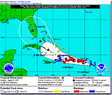
The 11 am advisory notes some small changes to the forecast track of Tropical Storm Irene, and the National Hurricane Center has issued an important reminder in their latest discussion:
THERE IS A FAIR AMOUNT OF SPREAD IN THE TRACK GUIDANCE MODELS...ESPECIALLY AT DAYS 4 TO 5. FOR EXAMPLE...THE GFDL MODEL TAKES IRENE TO THE WEST OF THE FLORIDA PENINSULA WHILE THE HWRF MODEL TAKES IT THROUGH THE NORTHWESTERN BAHAMAS.
INTERESTS IN FLORIDA ARE ADVISED NOT TO FOCUS ON THE EXACT FORECAST TRACK BECAUSE OF THE INHERENT UNCERTAINTIES IN LONGER-RANGE FORECASTS.
This track may well shift several times over the next couple of days. It is also important to note that severe weather conditions can often occur more than 100 miles away from where the center of these storms pass.
Latest `spaghetti’ computer runs 11am 8/21/11
We’ll have a much better idea of where Irene will go, and how strong she may become, after this system clears the islands of Puerto Rico, Hispaniola, and Cuba.
Interests in Florida, and along the Gulf coast and Atlantic seaboard, should stay on top of this storm’s progress and make sure their hurricane plans and preparations are in order.

