# 5771
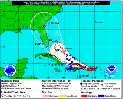
Irene reached hurricane status overnight as she moved over the island of Puerto Rico, and now appears poised to miss most of the mountainous terrain of Hispaniola which should allow her to strengthen.
The consensus track puts Irene as a strong hurricane moving along the eastern seaboard of Florida by the end of the week. It should be noted that there is still a fair amount of uncertainty on this forecast path and the models have been shifting with every run.
5am EST 8/22 Computer models
The National Hurricane Center in their 5am advisory, released this intensity forecast, but cautioned that this might be conservative depending upon the storm’s interaction with the mountains of Hispaniola.
The bottom line, despite some remaining uncertainties regarding her track and intensity, residents and interests from the Florida Keys, up along the Florida coastline, and even further north along the eastern seaboard need to be getting ready just in case Irene decides to visit.
Only two hurricanes have impacted the northeast coast of Florida over the past thirty years, and so millions of residents – from Melbourne to Jacksonville – have yet to experience a serious hurricane.
Hurricane David (1979) and Hurricane Charlie (2005) tracks.
Credit – NOAA Historical Hurricane Tracks
For emergency managers all along the coast, the next 120 hours are going to be a tense and hectic time. More than a dozen Florida counties are under the gun in this latest forecast track, and Georgia, the Carolinas, and points north are not out of danger.
NOW is the time to review your emergency plan, including where you will go if you are ordered to evacuate, and to make any last minute additions to your emergency kit.
To help in this regard, a couple of short videos from the Pinellas County Office of Emergency Management on preparing for a hurricane.
Time: 3 min. 30 sec.
Building a hurricane survival kit doesn't have to break the bank. Learn how to put together a well-stocked kit inexpensively.
Time: 4 min.
When a storm blows in, you put masking tape on your windows and you're fine right? We'll show you just how wrong that assumption can be.
The National Hurricane Center website should always be your primary source of forecast information, but if you are on Twitter, you should also follow @FEMA, @CraigatFEMA, @NHC_Atlantic, @NHC_Pacific and @ReadydotGov for the latest Emergency information.
To become better prepared as an individual, family, business owner, or community to deal with hurricanes, tornadoes, floods, or any other type of disaster: visit the following preparedness sites.
FEMA http://www.fema.gov/index.shtm
READY.GOV http://www.ready.gov/
AMERICAN RED CROSS http://www.redcross.org/


