# 6518
The nemesis of tropical storms and hurricanes is the crossing of land, as that interrupts the fuel supply they derive from passing over warm ocean waters. Mountainous terrain can further disrupt their circulation, and many a storm has thrashed themselves to pieces crossing Cuba or Hispaniola.
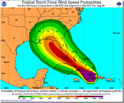
The latest forecast from the NHC has Isaac attempting to thread the needle between the elevated terrain of Haiti to its east, and Cuba to its west, as it moves in a northwesterly direction through the Windward Passage.
All of which suggests Isaac will spend less time over land than previously thought, and has a better opportunity to intensify to hurricane strength before reaching the Florida Keys.
Accordingly, overnight Hurricane warnings have been posted for:
- The Florida Keys, including the Dry Tortugas
- The West Coast of Florida from Bonita Beach Southward to Florida Bay
The National Hurricane Center’s 5am Discussion has this to say about Isaac’s future.
GIVEN THAT THE CYCLONE HAS FARED RATHER WELL AFTER MOVING ACROSS HAITI...AND THAT THE TRACK FORECAST HAS ONLY MINIMAL INTERACTION WTH CUBA...THE INTENSITY FORECAST AFTER 12 HOURS HAS BEEN ADJUSTED UPWARD FOLLOWING THE TREND OF THE LATEST INTENSITY GUIDANCE.
ISAAC ISEXPECTED TO BECOME A HURRICANE IN ABOUT 36 HOURS...WITH ADDITIONAL INTENSIFICATION EXPECTED AS THE CYCLONE MOVES INTO THE EASTERN GULF OF MEXICO IN A FAVORABLE ENVIRONMENT. THE NEW NHC INTENSITY FORECAST IS CLOSE TO THE INTENSITY CONSENSUS AIDS THROUGH 72 HOURS AND FOLLOWS A BLEND OF THE DECAY SHIPS AND LGEM AFTERWARD.

Given that Tropical Storm force winds extend more than 200 miles from the center, the exact path of Isaac is of less importance than one might think.
Tropical storm conditions may be expected along much of Florida’s west coast (and even into the center of the state) over the next couple of days.
Landfall is now expected in about 3 days along the northern Gulf coast, and the storm could be approaching CAT 2 strength at that time.
Despite not yet achieving hurricane strength, residents along the path of this storm need to be making their preparations for Isaac’s arrival.
When it comes to getting the latest information on hurricanes, your first stop should always be the National Hurricane Center in Miami, Florida. These are the real experts, and the only ones you should rely on to track and forecast the storm.
The second official information source you should have bookmarked is your local Office of Emergency Management. There you will find information about evacuation zones, shelters, and emergency decrees in your area.
If you are on Twitter, you should also follow @FEMA, @CraigatFEMA, @NHC_Atlantic, @NHC_Pacific and @ReadydotGov.
And a reminder, this year emergency management officials are trying once again to dispel the widespread belief that taping windows provides protection during a hurricane (see The Tale Of The Tape).
Up until the 1970s, it was pretty much standard advice to homeowners to tape plate glass windows to keep them from shattering, but that advice was discredited, and has not been part of hurricane prep advice for 30 years.
Not only does taping windows provide a false sense of security, it can bind shards of flying glass into larger, and more dangerous, projectiles.
Still, the myth hangs on.
A video that I’ve highlighted in the past, from the Pinellas County Office of Emergency Management demonstrates just how useless masking, or duct taping your your windows really is during a storm (be patient, it can take a minute to load).
Time: 4 min.
When a storm blows in, you put masking tape on your windows and you're fine right? We'll show you just how wrong that assumption can be.
If you haven’t already downloaded the Tropical Cyclone Preparedness Guide, now would be an excellent time to do so. It is a short (12-page), easy to follow guide that will walk you through the basics of understanding (and surviving) hurricanes and tropical storms.


