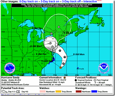
Credit NHC 11am Sunday Track Map
# 6673
While it is impossible to know just how bad Hurricane-Hybrid Sandy will be as it approaches and crosses the eastern seaboard over the next 48 hours – or who, exactly, will be most affected – models continue to paint a sobering picture.
Tidal surge models from the National Hurricane Center suggest that large areas of the coastline could see storm tides 5-10 feet above normal.
The following map is for a 5 ft surge:
Some models are suggesting that portions of New York Harbor could see tides exceeding 10 feet above normal, and the 11am advisory warns:
STORM SURGE...THE COMBINATION OF AN EXTREMELY DANGEROUS STORM SURGE AND THE TIDE WILL CAUSE NORMALLY DRY AREAS NEAR THE COAST TO BE FLOODED BY RISING WATERS. THE WATER COULD REACH THE FOLLOWING DEPTHS ABOVE GROUND IF THE PEAK SURGE OCCURS AT THE TIME OF HIGH TIDE...
NC NORTH OF SURF CITY INCLUDING PAMLICO/ALBEMARLE SOUNDS...4 TO 6 FT
SE VA AND DELMARVA INCLUDING LOWER CHESAPEAKE BAY...2 TO 4 FT
UPPER AND MIDDLE CHESAPEAKE BAY...1 TO 3 FT
LONG ISLAND SOUND...RARITAN BAY...AND NEW YORK HARBOR...6 TO 11 FT
ELSEWHERE FROM OCEAN CITY MD TO THE CT/RI BORDER...4 TO 8 FT
CT/RI BORDER TO THE SOUTH SHORE OF CAPE COD INCLUDING BUZZARDS
BAY AND NARRAGANSETT BAY...3 TO 6 FT
Based on the forecast of surge tides, heavy rains, and high winds the City of New York will suspend mass transit routes starting at 7pm tonight.
Gov: MTA will suspend all subway, bus and rail service as Hurricane Sandy advances
Last subway and rail trains will be at 7; last bus at 9pm
By Shane Dixon Kavanaugh / NEW YORK DAILY NEWS
The last time the New York Subway system was shut down due to flooding was for Hurricane Irene in 2011. The NYC MTA carries more than 8 million passengers on a typical weekday, and shutting down the entire system will take 8 to 10 hours (cite WSJ).
From Johns Hopkins University, we get this `model’ of possible power outages due to Sandy, based on current track forecasts.
MEDIA ADVISORY: Hurricane Sandy – 10 million could lose power
As many as 10 million in the mid-Atlantic will lose power in the coming week, according to a computer model developed by an engineer at The Johns Hopkins University.
Please note: A multicolored map of power outage predictions is available. Email acl@jhu.edu
A map of power outages as predicted by Guikema’s model based on the official National Hurricane Center track and intensity forecast from 18UTC (3 p.m. EDT) on Saturday, Oct. 27.
An engineer at The Johns Hopkins University predicts that 10 million people from northern Virginia through New Jersey and into southeastern Pennsylvania will be without power in the wake of Hurricane Sandy. Seth Guikema (pronounced Guy-keh-ma) and his team have developed a computer model built on outage data from 11 hurricanes to estimate the fraction of customers who will lose power, based on expected gust wind speed, expected duration of strong winds greater than 20 meters per second, and population density. They ran their model using the official National Hurricane Center track and intensity forecast from 18UTC (3 p.m. EDT) on Saturday, and emphasize that the number of power outages could change as the storm progresses and forecasts become more definitive. It is possible that 10 million people is a conservative estimate, Guikema said.
Guikema’s model may help power companies allocate resources by predicting how many people will be without power and where the most outages will take place, and it provides information that emergency managers can use to better prepare for storms. Guikema, an assistant professor in the Department of Geography and Environmental Engineering at the Johns Hopkins Whiting School of Engineering, says the goal is to restore power faster and save customers money. Guikema will be running the model throughout the weekend and into next week as Hurricane Sandy makes landfall.
The Governor of New Jersey warned yesterday that power could be out for some residents for `seven to ten days’. And for many people, that means no ability to cook, or to heat their homes.
Municipal water supplies, or water quality, could be affected as well. Hence the need to be prepared to go several days - at least - without city services or utilities.
And while most people automatically worry about storm surge or high winds from hurricanes, between 1970 and 1999, the most lives have been claimed due to inland flooding.
The NHC has released this five-day precipitation forecast, which should provide some idea of the extent of flooding that may occur.
While it is possible that Sandy won’t be as destructive as has been billed, storms like Camille, Andrew, and Katrina have shown us the folly of underestimating nature’s fury.
Today is the last day that people in the path of this storm will have to prepare. Those who are ordered to evacuate need to do so immediately.
To help track this storm, you may wish to revisit my blog from yesterday Resources To Follow The Northeast Storm Online.


