# 8803
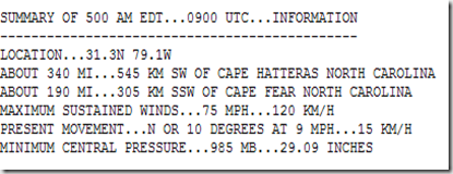
Arthur, a category one hurricane, is expected to pass very close to the outer banks of North Carolina this evening on its trek north. While most of the worst of the weather will likely remain offshore, areas along the coastline are likely to take a pounding.

Residents in the affected areas should be completing their hurricane preparations now (see Hurricane Preparedness Week: Make A Plan).
Storms that form in June and early July generally form in the Caribbean, the Gulf of Mexico, or just off the coast of the United States – as has Arthur.
June Tropical Climatology
Credit NOAA
As the summer progresses the spawning grounds for Hurricanes moves further east into the warming Atlantic ocean. But it usually isn’t until August and September that the Cape Verde basin begins to produce what often turn into the largest and most persistent storms.
July & August Tropical Climatology
And the number of storms increases as we get later in the summer, with the peak of activity usually in the first half of September. Hurricane season lasts through November 30th, however, and so late season storms are always possible.
You can find much more on Hurricane Climatology at NOAA’s Tropical Cyclone Climatology page.
When it comes to getting the latest information on hurricanes, your first stop should always be the National Hurricane Center in Miami, Florida. These are the real pros, and the only ones you should rely on to track and forecast the storm.
- Tropical storm watches will be issued when tropical storm conditions are possible along the coast within 48 hours.
- Tropical storm warnings will be issued when those conditions are expected within 36 hours. Similar increases in lead-time will apply to hurricane watches and warnings.
This year the NHC has also introduced a new five-day graphical forecast, showing the areas of the tropics where tropical development is possible (or expected) over the next 120 hours. Here is how NOAA describes this new feature:
Five-Day Graphical Tropical Weather Outlook Introduced
Beginning at 2 p.m. EDT July 1st , NOAA’s National Hurricane Center (NHC) will introduce an experimental five-day Graphical Tropical Weather Outlook (GTWO) to accompany its text Tropical Weather Outlook (TWO).
The new five-day GTWO, available for both the Atlantic and eastern North Pacific basins, will indicate the formation potential of current and future disturbances during the next five days.Shaded areas will represent the potential tropical cyclone formation areas, color-coded by development likelihood, with yellow representing a low (<30%) chance, orange denoting a medium (30% to 50%) chance, and red corresponding to a high (>50%) chance of tropical cyclone formation during the next five days. The location of each current disturbance will be denoted by an “X”. A mouse-over feature will allow users to see the accompanying Outlook text for each system. Clicking on an area will display a graphic showing only that disturbance, which should improve clarity when the forecast genesis areas overlap. Because the new five-day GTWO will tend to be busier than the current 48-hour GTWO, the five-day graphic will not display the locations of existing tropical cyclones.
Here is an example of the new five-day GTWO:
For now, with the exception of Arthur, the Atlantic Basin and Caribbean are quiet, with no tropical development expected.
Making this 4th of July weekend a good time to go over your hurricane (and other disaster) preparedness plans, making sure you, your family, and your business are prepared to deal with whatever unexpected situation that life, and nature, can throw at you.
In addition to the preparedness information you can find on the FEMA and READY.GOV websites, a few of my earlier preparedness blogs include:


