Showing posts with label Swarm. Show all posts

Saturday, November 02, 2013

Oklahoma Insurance Commissioner Warns On Earthquake Risks

image

Earthquakes last 7 Days – Credit Leonard Geophysical Laboratory


# 7930


While Oklahomans are more accustomed to threats dropping down from the sky than they are from those rising under their feet, as I wrote about 10 days ago (see USGS: Oklahoma Earthquake Swarm Continues), Oklahoma has seen an abrupt rise in the number of small earthquakes since 2009. 


A reminder that that threats can change over time, and with that, so must our readiness and response.


The swarm of (mostly small) earthquakes - particularly north and east of Oklahoma City -  continues unabated, which has prompted the Insurance Commissioner of the state to remind residents that regular homeowners policies do not cover earthquake damage, and encourages them to buy earthquake coverage.


First stop, the press release, followed by some `Earthquake Insurance’ realities,  after which I’ll be back with a bit more.


News Release Header

Commissioner Doak Encourages Homeowners to Purchase Earthquake Insurance

OKLAHOMA CITY – Oklahoma Insurance Commissioner John D. Doak is encouraging Oklahomans to purchase earthquake insurance after a new report predicts continued seismic activity in the central part of the state. The U.S. Geological Survey (USGS) said central Oklahoma has experienced more than 200 magnitude 3.0 or greater earthquakes since January 2009.

“Looking into earthquake insurance after your home or business has sustained damage resulting from an earthquake will do little good to help you recover,” said Doak. “Now is the time to protect yourself before the next one occurs.”

USGS reports an average of 40 earthquakes per year in Oklahoma from 2009 to 2013, an increase from an average of two to six yearly from 1975 to 2008. Oklahoma’s record-breaking 5.6-magnitude quake in November 2011 destroyed 14 homes and damaged dozens more. However, an estimated less than one percent of Oklahomans carry earthquake insurance. Standard homeowners or renters insurance policies do not cover damage caused from earthquakes.

(Continue . . .)


The State of Oklahoma  provides an Earthquake Insurance `Basics’ webpage, which provides a great deal of information on how to obtain coverage, and some of the limitations of these policies.  

oklahoma earthquakes

  • Earthquake insurance typically must be purchased apart from a standard homeowners policy, either as an “endorsement” added to the policy by the company that carries the purchaser’s homeowners insurance, or as a separate policy from a company specializing in earthquake coverage. Consumers will also have to wait a period of time – usually 30 to 60 days – after the most recently reported earthquakes in their area before they can purchase new earthquake insurance, due to the likelihood of aftershocks.
  • The cost of an earthquake policy varies depending on factors, including the carrier and the policyholder’s desired level of coverage, but typically an Oklahoma homeowner might expect to pay between $100 and $150 per year for earthquake insurance.
  • Earthquake policies frequently have nuances, such as providing or not providing coverage for brick or stone veneers on the home.
  • Earthquake insurance carries a separate and often substantial deductible, apart from the standard homeowners deductible. Often this deductible is calculated as a percentage of the insured property’s value – commonly 5 to 10 percent, but occasionally lower or higher – meaning that a $100,000 home would require a deductible of $5,000 to $10,000. 
  • (Continue . . . )


    Less costly, but no less important, is having a good earthquake disaster plan, and the supplies you will need in the event of a major quake. 


    While many natural disasters – like hurricanes, wild fires, and tornados – have a `season’, earthquakes can come at any time and without warning.  Which means that any earthquake plan – particularly in the North and Midwest – must anticipate what you would do if a quake hits in the middle of winter.


    Compared to West Coast earthquakes, those that occur in the Midwest and Eastern half of the country tend to be felt across a much larger area (see USGS: Eastern Earthquakes - Rare But Powerful). The following shake map from the USGS shows the areas reporting shaking from two recent quakes, a 6.0 in Central California, and the recent 5.8 Virginia quake. By an incredibly large margin, the smaller eastern quake was felt over a much bigger area.

    image


    And the effects of an earthquake can go far beyond the loss of life and property damage.  Ripple effects caused by economic losses can affect regions far removed from the epicenter. In 2011, in The Ripple Effect, we saw that 2/3rds of all businesses in New Zealand were economically impacted by the Christchurch earthquakes.


    Working to improve earthquake awareness, preparation, and safety is Shakeout.org, which promotes yearly earthquake drills and education around the country (see NPM13: A Whole Lotta Shakeouts Going On).  If you live in one of these seismically active areas, I would encourage you to take part in these yearly drills.

    image


    As a bare minimum, everyone should have a well thought out disaster and family communications plan, along with a good first aid kit, a `bug-out bag’, and sufficient emergency supplies to last at least 72 hours.


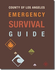
    In When 72 Hours Isn’t Enough, I highlighted  a colorful, easy-to-follow, 100 page `survival guide’ released by Los Angeles County, that covers everything from earthquake and tsunami preparedness, to getting ready for a pandemic.

    image

    The guide may be downloaded here (6.5 Mbyte PDF).

    While designed specifically for the nearly 10 million residents of Los Angeles County, this guide would be a valuable asset for anyone interested in preparing for a variety of hazards. And in Los Angeles, the advice is to have emergency supplies (food, water, etc) to last up to 10 days. In my humble opinion, 2-weeks in an earthquake zone isn’t overkill.
     

    To become better prepared as an individual, family, business owner, or community to deal with all types of disasters, I would invite you to visit the following preparedness sites.


    FEMA http://www.fema.gov/index.shtm

    READY.GOV http://www.ready.gov/

    AMERICAN RED CROSS http://www.redcross.org/


    And lastly, in NPM13: The Greatest Prep Of All,  I wrote about what I consider to be the most important preparedness step you can take – having, and being,  a disaster buddy.  Cultivating a network of family and friends to whom you can turn for help in a disaster, to who can turn to you for aid,  if they need it.


    Because no matter where you live, its just a matter of time before the next disaster strikes.

    Tuesday, October 22, 2013

    USGS: Oklahoma Earthquake Swarm Continues

    image

      3.5+Mag quakes – Credit USGS 


    # 7887


    Almost 2 years ago, in November of 2011, I wrote about a 5.6 Mag Quake that Rattled Oklahoma.  At the time I noted that the state of Oklahoma had seen an unusual number of earthquakes over the previous couple of years. In 2010, the Oklahoma Geological Survey Observatory recorded 1,047 earthquakes, of which 103 were strong enough to be felt by the public.


    Since that time, Oklahoma’s earthquake swarm has continued, producing more than 200 3.0+ magnitude temblors over the past 4 years.


    Today the USGS, in partnership with the Oklahoma Geological Survey, has released a report on this ongoing swarm, and how it affects the risks for seeing larger quakes in the region.   I’ve excerpted the key message (bolding mine) below:

    Important to people living in the Oklahoma City region is that earthquake hazard has increased as a result of the swarm. USGS calculates that ground motion probabilities, which relate to potential damage and are the basis for the seismic provisions of building codes, have increased in Oklahoma City as a result of this swarm.  While it’s been known for decades that Oklahoma is "earthquake country," the increased hazard has important implications for residents and businesses in the area.


    The full news release follows:


    Earthquake Swarm Continues in Central Oklahoma


    Released: 10/22/2013 1:07:59 PM

    Contact Information:
    U.S. Department of the Interior, U.S. Geological Survey
    Office of Communications and Publishing
    12201 Sunrise Valley Dr, MS 119
    Reston, VA 20192
    Heidi  Koontz 1-click interview
    Phone: 303-202-4763

    In partnership with: Oklahoma Geological Survey

    Since January 2009, more than 200 magnitude 3.0 or greater earthquakes have rattled Central Oklahoma, marking a significant rise in the frequency of these seismic events.


    The U.S. Geological Survey and Oklahoma Geological Survey are conducting collaborative research quantifying the changes in earthquake rate in the Oklahoma City region, assessing the implications of this swarm for large-earthquake hazard, and evaluating possible links between these earthquakes and wastewater disposal related to oil and gas production activities in the region.


    Studies show one to three magnitude 3.0 earthquakes or larger occurred yearly from 1975 to 2008, while the average grew to around 40 earthquakes per year from 2009 to mid-2013.


    "We've statistically analyzed the recent earthquake rate changes and found that they do not seem to be due to typical, random fluctuations in natural seismicity rates," said Bill Leith, USGS seismologist. "These results suggest that significant changes in both the background rate of events and earthquake triggering properties needed to have occurred in order to explain the increases in seismicity. This is in contrast to what is typically observed when modeling natural earthquake swarms."


    The analysis suggests that a contributing factor to the increase in earthquakes triggers may be from activities such as wastewater disposal--a phenomenon known as injection-induced seismicity. The OGS has examined the behavior of the seismicity through the state assessing the optimal fault orientations and stresses within the region of increased seismicity, particularly the unique behavior of the Jones swarm just east of Oklahoma City. The USGS and OGS are now focusing on determining whether evidence exists for such triggering, which is widely viewed as being demonstrated in recent years in Arkansas, Ohio and Colorado.


    This "swarm" includes the largest earthquake ever recorded in Oklahoma, a magnitude 5.6 that occurred near Prague Nov. 5, 2011.  It damaged a number of homes as well as the historic Benedictine Hall at St. Gregory's University, in Shawnee, Okla.  Almost 60 years earlier in1952, a comparable magnitude 5.5, struck El Reno and Oklahoma City. More recently, earthquakes of magnitude 4.4 and 4.2 hit east of Oklahoma City on April 16, 2013, causing objects to fall off shelves.


    Following the earthquakes that occurred near Prague in 2011, the agencies issued a joint statement, focusing on the Prague event and ongoing seismic monitoring in the region.  Since then, the USGS and OGS have continued monitoring and reporting earthquakes, and have also made progress evaluating the significance of the swarm.


    Important to people living in the Oklahoma City region is that earthquake hazard has increased as a result of the swarm. USGS calculates that ground motion probabilities, which relate to potential damage and are the basis for the seismic provisions of building codes, have increased in Oklahoma City as a result of this swarm.  While it’s been known for decades that Oklahoma is "earthquake country," the increased hazard has important implications for residents and businesses in the area.


    To more accurately determine the locations and magnitudes of earthquakes in Oklahoma, the OGS operates a 15-station seismic network.  Data from this system, and from portable seismic stations installed in the Oklahoma City region, are sent in real-time to the USGS National Earthquake Information Center, which provides 24x7 reporting on earthquakes worldwide.


    The State of Oklahoma maintains an earthquake safety webpage at EARTHQUAKE SAFETY,  while additional Oklahoma specific earthquake monitoring and research information can be found at the Oklahoma Geological Survey.


    Although the west coast is most noted for its seismic hazards, America’s heartland and parts of the Eastern Seaboard are susceptible to moderate to strong quakes.   A topic I covered about a year ago in USGS: Eastern Earthquakes - Rare But Powerful


    image


    Given the risks, the United States government devoted their National Level Exercise (NLE 2011) two years ago to a simulated catastrophic earthquake in the New Madrid Seismic Zone (NMSZ).We live on a violent planet, one that is prone to storms, fires, floods, drought, volcanoes, earthquakes and myriad other natural disasters.Emergencies happen every day.


    Disasters, admittedly, less often. But in either event, preparedness is key.


    At a bare minimum, every household should have a disaster plan, a good first aid kit (and the knowledge to use it), an emergency battery operated NWS weather radio, and emergency supplies to last a minimum of 72 hours during a disaster.To become better prepared as an individual, family, business owner, or community, I would invite you to visit the following preparedness sites.

    FEMA http://www.fema.gov/index.shtm

    READY.GOV http://www.ready.gov/

    AMERICAN RED CROSS http://www.redcross.org/


    For more on increasing your level of preparedness, a partial list of some of my preparedness blogs include:

    When 72 Hours Isn’t Enough

    In An Emergency, Who Has Your Back?

    An Appropriate Level Of Preparedness

    Monday, February 28, 2011

    Arkansas Earthquake Swarm: 4.7 Magnitude Overnight


    # 5343


    Nine days ago I wrote about the ongoing swarm of earthquakes occurring in and around Guy, Arkansas in a blog called USGS: The Arkansas Earthquake Swarm. Since then the temblors have continued, with the latest being a 4.7 and a 3.8 magnitude quake overnight.


     image

    Note: The two latest shocks (depicted by the blue boxes) are obscuring an additional 52 smaller quakes in the past 7 days in this graphic.


    While a bit unnerving for local residents, based on the USGS produced shake map for last night’s shallow 4.7 magnitude event, the quake was likely to be only moderately felt north of Little Rock, and damage – if any – should be `very light’.


    image


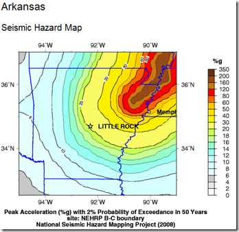
    Arkansas is no stranger to seismic events, although the main quake dangers are focused more in the northeast corner of the state, and associated with the New Madrid fault line.


    image


    Strong – even damaging quakes – have occurred outside of the New Madrid region in Arkansas over recorded history.  On the University of Arkansas’s (Little Rock) earthquake history page you’ll find descriptions of a number of quakes over the past 200 years.


    One of the largest in recent memory occurred on New Year’s Day, 1969, and is briefly described:


    On January 1, 1969, a tremor centered about 19 miles northwest of Little Rock and caused much commotion in the area. In Little Rock, plaster cracked, and furniture was moved about in some homes; and trees and utility wires swayed and shook throughout a wide area. The shock was also noted by residents in southern Missouri and western Tennessee.


    In 1982 and again in 2001 a prolonged series of temblors struck very near the same region as we are seeing activity today, in what was called the Enola Earthquake Swarms


    Enola is located only 20 miles or so to the south-east of this current area of activity. The Arkansas Geological Survey website gives a nice accounting of this swarm. 


    A small excerpt follows:


    The Enola swarm was initiated by a magnitude 1.2 earthquake recorded on January 12, 1982 near the town of Enola in Faulkner County, Arkansas. Since then, over 40,000 seismic events have been recorded in the Enola area. Most of the recorded seismic events are microquakes, but at least 93 earthquakes have been felt in the local area by at least one person during the first year of seismic activity. Earthquake magnitudes have not exceeded a 4.5, which occurred on Jan. 21, 1982. No structural damage has ever occurred, although there have been reports of broken china.


    As far as whether these latest shocks are a harbinger of bigger things to come?   The USGS has this to say about earthquake swarms east of the Rockies.


    Earthquake swarms are common east of the Rocky Mountains; although none of the others have involved so many small earthquakes as the central Arkansas swarms. Scientists don't know why swarms start, why they stop, or how long to expect them to last.

    The possibility of a larger earthquake cannot be discounted but none of the other swarms have given us any reason to expect an earthquake large enough to cause significant damage in central Arkansas in the near future.

    Most of North America east of the Rocky Mountains has infrequent earthquakes that can strike anywhere at irregular intervals. The causes of earthquakes are not understood well enough for us to predict earthquakes reliably.


    Since earthquakes are unpredictable, the only rational response if you live in a seismically active area is to be prepared to deal with one if it happens.


    In Because It Can Happen Here, I provided a long list of preparedness links, which I would encourage you to follow.


    FEMA, READY.GOV and the American Red Cross all strongly encourage you to be prepared to deal with a wide range of emergencies, including earthquakes, fires, tornadoes, floods, or hurricanes.


    They know that during a major crisis, they may not be able to provide assistance to everyone during the first crucial 72 hours.  


    You and your family need to be capable of fending for yourselves, and hopefully helping your neighbors, until help can arrive and services are restored.


    As Ready.gov reminds us:

    image

    Do it today.