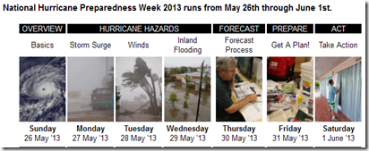
NOAA National Hurricane Preparedness Week
# 7316
As a native Floridian who has spent roughly 50 of his nearly 60 years living in the Sunshine state (with 15 of those years living aboard a variety of boats) – I have an understandable interest (read: `morbid fascination’) with hurricanes.
During much of my youth the Atlantic basin was in an active hurricane cycle, which provided me with an early education on these storms.
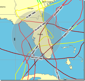
Here are the storm tracks of the hurricanes that crossed Florida during my youth, in the years between 1954-1972.
By the 1970s, the cycle had wound down, and by comparison, the next twenty years were relatively quiet, which fueled complacency and intense coastal construction. Here are the storms that came close between 1973 and 1994.

But we are back into an active tropical cycle, as yesterday’s announcement from NOAA reaffirms, with their prediction of another above average hurricane season ahead.
NOAA predicts active 2013 Atlantic hurricane season
Era of high activity for Atlantic hurricanes continues
May 23, 2013
Hurricane Sandy as seen from NOAA's GOES-13 satellite on October 28, 2012.
Download here (Credit:NOAA/NASA)
In its 2013 Atlantic hurricane season outlook issued today, NOAA’s Climate Prediction Center is forecasting an active or extremely active season this year.
For the six-month hurricane season, which begins June 1, NOAA’s Atlantic Hurricane Season Outlook says there is a 70 percent likelihood of 13 to 20 named storms (winds of 39 mph or higher), of which 7 to 11 could become hurricanes (winds of 74 mph or higher), including 3 to 6 major hurricanes (Category 3, 4 or 5; winds of 111 mph or higher).
These ranges are well above the seasonal average of 12 named storms, 6 hurricanes and 3 major hurricanes.
“With the devastation of Sandy fresh in our minds, and another active season predicted, everyone at NOAA is committed to providing life-saving forecasts in the face of these storms and ensuring that Americans are prepared and ready ahead of time.” said Kathryn Sullivan, Ph.D., NOAA acting administrator. “As we saw first-hand with Sandy, it’s important to remember that tropical storm and hurricane impacts are not limited to the coastline. Strong winds, torrential rain, flooding, and tornadoes often threaten inland areas far from where the storm first makes landfall.”
Three climate factors that strongly control Atlantic hurricane activity are expected to come together to produce an active or extremely active 2013 hurricane season. These are:
- A continuation of the atmospheric climate pattern, which includes a strong west African monsoon, that is responsible for the ongoing era of high activity for Atlantic hurricanes that began in 1995;
- Warmer-than-average water temperatures in the tropical Atlantic Ocean and Caribbean Sea; and
- El Niño is not expected to develop and suppress hurricane formation.
“This year, oceanic and atmospheric conditions in the Atlantic basin are expected to produce more and stronger hurricanes,” said Gerry Bell, Ph.D., lead seasonal hurricane forecaster with NOAA’s Climate Prediction Center. “These conditions include weaker wind shear, warmer Atlantic waters and conducive winds patterns coming from Africa."

While Floridians and Gulf Coast residents are a bit more cognizant of the hurricane threat, you don’t have to live in the south – or even near the coast – to be affected by these monster storms.
All next week we’ll be talking about hurricane (and `all hazards’) preparedness issues as part of National Hurricane Preparedness Week.
Whether you live in reach of one of these tropical systems or not, this coming week will be an opportune time to review your family and/or business disaster plans.
Because we can’t know when the next disaster will strike, or even what form it may take.
We just know that they happen with disturbing regularity, and that the advantage always goes to those who were prepared.


