# 5727
Although August is still one day away, it appears likely that the 5th named tropical system of the 2011 Atlantic Hurricane season is about to form about 600 miles east of the Windward Islands.
The National Hurricane Center in Miami, Florida has this area of disturbed weather listed as having a high chance – nearly 100% - of forming into a depression or storm in the next 48 hours.
From the looks of the latest satellite photos, that may yet happen today.
The 8am EST tropical outlook states:
IF THE LOW BECOMES A TROPICAL
CYCLONE LATER TODAY... TROPICAL STORM WATCHES OR WARNINGS WOULD LIKELY BE REQUIRED FOR PORTIONS OF THE NORTHERN WINDWARD ISLANDS AND THE LEEWARD ISLANDS.INTERESTS IN THESE AREAS SHOULD CLOSELY MONITOR THE PROGRESS OF THIS SYSTEM. AN AIR FORCE RESERVE UNIT RECONNAISSANCE AIRCRAFT IS SCHEDULED TO INVESTIGATE THIS DISTURBANCE LATER THIS AFTERNOON.
It is a little too soon to project where this storm will go, as hurricane computer models don’t really initialize well until the storm’s circulation matures.
Early guidance, however, suggests that beyond the Windward & Leeward Islands . . . Puerto Rico, Hispaniola, and the Bahamas need to be paying close attention.
August is when the Atlantic hurricane season really begins to pick up steam, and that trend usually peaks in mid-September.
Compare the areas of origin and typical hurricane tracks in these two maps (below) showing July and August, and you will see a considerable amount of difference.

You’ll notice that the system we are watching is just now entering the orange `Most Likely’ area of development east of the Windward Islands.
As the summer progresses the spawning grounds for Hurricanes moves further east into the warming Atlantic ocean. It isn’t until August and September that the Cape Verde basin begins to produce what often turn into very large and persistent hurricanes.
You can find much more on Hurricane Climatology at NOAA’s Tropical Cyclone Climatology page.
When it comes to getting the latest information on hurricanes, your first stop should always be the National Hurricane Center in Miami, Florida. These are the real experts, and the only ones you should rely on to track and forecast the storm.
Last year there were some significant changes in how the NHC will advise us on hurricanes. Some of the (excerpted) highlights include:
Watches and warnings for tropical storms and hurricanes along threatened coastal areas will be issued 12 hours earlier than in previous years.
- Tropical storm watches will be issued when tropical storm conditions are possible along the coast within 48 hours.
- Tropical storm warnings will be issued when those conditions are expected within 36 hours. Similar increases in lead-time will apply to hurricane watches and warnings.
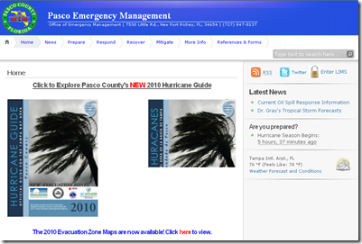
The second official information source you should have bookmarked is your local Office of Emergency Management. Here you’ll be able to access local warnings, flood maps and evacuation information.
To find it, you can Google or Yahoo search with your county/parish name and the words `Emergency Management’. Below you’ll find a screenshot of the entry page to my county’s page.
If you are on Twitter, you should also follow @FEMA, @CraigatFEMA, @NHC_Atlantic, @NHC_Pacific and @ReadydotGov.
NOAA’s NWS National Hurricane Center in Miami also has a Facebook page, where you can keep up with the latest tropical developments.
Of course, knowing about an approaching storm isn’t enough. You need to be prepared as well.
Since last May was National Hurricane Preparedness week, this blog devoted considerable time to the subject. A few of my blogs on hurricane preparedness included:
National Hurricane Preparedness Week 2011
Hurricane Preparedness Week: Inland Flooding
With the busiest two months of the hurricane season about to begin, if you haven’t already done so, now is the right time to make preparations.


