Showing posts with label Irene. Show all posts

Sunday, August 28, 2011

Not Quite Goodnight For Irene


image

# 5790


Although not the nightmare storm that many envisioned, Hurricane Irene has left between 2 and 3 million people in her path without power, has damaged homes, businesses and local infrastructure, produced serious flooding, and has reportedly claimed the lives of at least 9 people over the past couple of days.


And while a minimal hurricane as of the 5am update from the NHC, she isn’t done yet.  She will pass over Long Island later this morning before moving inland over New England this afternoon.


The National Hurricane Center describes the storm’s condition this morning:


HURRICANE FORCE WINDS EXTEND OUTWARD UP TO 125 MILES...205 KM...FROM THE CENTER...AND TROPICAL STORM FORCE WINDS EXTEND OUTWARD UP TO 320 MILES...520 KM.  LA GUARDIA AIRPORT IN NEW YORK CITY RECENTLY REPORTED A SUSTAINED WIND OF 41 MPH...67 KM/H...AND A WIND GUST OF 64 MPH...104 KM/H.  A SUSTAINED WIND OF 40 MPH...65 KM/H...AND A WIND GUST OF 58 MPH...93 KM/H...WERE ALSO RECENTLY REPORTED AT JOHN F. KENNEDY INTERNATIONAL AIRPORT IN NEW YORK CITY.


WATER LEVELS HAVE BEEN RISING RAPIDLY IN ADVANCE OF THE CENTER OF IRENE...WITH RECENTLY OBSERVED STORM SURGE VALUES OF 3.9 FEET AT SANDY HOOK NEW JERSEY...3.8 FEET AT NEW YORK HARBOR...AND 3.1 FEET AT CAPE MAY NEW JERSEY.


Reports out of Norfolk, Va. indicated they saw a nearly 8 foot surge in some areas.  It may be a day or two before we can get reliable estimates from along the North Carolina coast.


Typical of the reports this morning: In Pennsylvania, more than 200,000 are without power, and according to PSE&G, it may take several days to restore electricity.


PSE&G Hurricane Irene Update: Aug. 28, 2011 at 5:30 a.m.

-- About 213,000 PSE&G customers are without power at this time statewide. The number of outages continues to climb as Hurricane Irene moves north. The utility, which provides electric service to 2.2 million customers, is estimating that power restoration may take several days to a week


There have also been reports of possible tornadoes spun up from Irene damaging homes and felling trees in Delaware, and New York City and many surrounding areas have been under tornado warnings and/or watches overnight.


While obviously not catastrophic, it will take a few days before we get a decent idea of just how much damage Irene has actually caused. 


Meanwhile, the NHC indicates there are a couple of new areas of suspicion brewing in the Atlantic, and we are just now coming up to the most active month in the Hurricane season.


image


Reason enough to make sure that you, your family, and your business are ready in case another storm heads in our direction.

Saturday, August 27, 2011

Of Hurricanes, Pandemics, And Intensity Forecasting


image

Irene looking a little ragged this morning


# 5789


For hurricanes, life is short and environmental threats to their existence are many. 


It takes the right balance of environmental factors; low wind shear, warm waters to traverse and feed from, little or no interaction with land masses, and abundant moist tropical air to keep them going full tilt.


Take away, or reduce any of these vital  components, and even powerful storms can quickly lose strength or fall apart altogether. 


Irene, which was forecast to be a major (Cat 3) hurricane at landfall only 24 hours ago, has instead weakened overnight into a strong CAT 1 storm, with sustained winds of 90 MPH and higher gusts.


Of course, even at CAT 1 strength, Irene is not something to trifle with. She is still capable of producing a serious amount of damage, particularly from storm surge, so those in her path should not let their guard down.


But her impact is likely to be less than originally feared.


From the 5am NHC discussion:


LAND INTERACTION...DRY AIR ENTRAINMENT...AND INCREASING VERTICALWIND SHEAR SHOULD CAUSE IRENE TO WEAKEN AS IT MOVES ALONG THE U.S. EAST  COAST. HOWEVER...THE CYCLONE IS EXPECTED TO REMAIN A HURRICANE WITH A VERY LARGE WIND FIELD UNTIL AFTER LANDFALL IN NEW ENGLAND.  EXTRATROPICAL TRANSITION SHOULD OCCUR AFTER THE NEW ENGLAND LANDFALL...WITH IRENE GRADUALLY WEAKENING FROM 48-120 HR.


As I’ve mentioned in the past, the  National Hurricane Center’s confidence in their intensity forecasting is less than in their forecast tracks.


The science is improving, but the number of constantly changing variables involved is absolutely staggering, and so storm intensity remains difficult to predict.


The conditions supporting a stronger Irene appeared to be in place.


She was far enough from land as to suffer little interference, the waters she was passing over were still relatively warm, and wind shear – although beginning to increase - had been low for the past several days.


But it appears that Irene has been weakened by the entrainment of drier air, pulled into the storm from the west. 


While there may be some who will claim the NHC overstated the dangers, and in doing so disrupted the lives of millions of people this weekend, the truth is this storm could easily have gone the other way, and become stronger.


And when it is your job to provide 48 hours warning of what could be a major threat, you can’t weasel-word your warnings just to give yourself a convenient `out’.


The conditions were there to keep Irene a major storm at landfall, and so with lives at stake, the only prudent thing was to assume that could happen.


A situation not so dissimilar to what public health officials faced a little over 2 years ago when a novel influenza virus emerged, and began spreading rapidly around the globe.


Despite many unknowns, the conditions were in place to support the declaration of a pandemic. Even though the World Health Organization stated the severity was impossible to predict, they were forced to assume the worst, and plan accordingly.


As with the NHC warnings on Irene, it was the right thing to do.


The fact that the pandemic proved less severe than first thought was pure luck. The next time, we may not be so fortunate.


Sadly, many people who ride through Irene this weekend may decide that hurricanes aren’t so bad after all. They will think they’ve gone through a major storm, when they really haven’t, and may fail to listen to officials and take prudent steps the next time a storm threatens.


Just like the millions of people who now believe that another flu pandemic isn’t anything to worry about, since the last one was so mild.


Since past performance is no guarantee of future results, either assumption could prove disastrous down the road.


The bottom line:  Even if we are lucky enough to dodge a bullet today . . . 


We shouldn’t assume ourselves to be bulletproof tomorrow.

Friday, August 26, 2011

Irene: 36 Hours Out


# 5785


Although Irene has failed to strengthen (and has actually weakened slightly overnight), she remains a large and formidable storm with sustained winds of 110 MPH. 


Irene is traveling over very warm waters that are conducive to maintaining, or perhaps even increasing, her strength and is now just about 36 hours away from an anticipated landfall along the North Carolina coast.


This is a very large storm with hurricane force winds extending as far as 90 miles from its center, and tropical force winds 290 miles. Her impact will be widely felt along a long stretch of the coast and further inland, and will affect millions of people over the next 72 hours.


image


For residents along the mid-Atlantic coastline, today is the last day to make any last minute preparations, and to leave if you must. Residents need to pay close attention to their local office of emergency management, and if advised to evacuate, do so immediately.


One of the biggest threats along the coastline will likely come from storm surge.The following video from the NHC (National Hurricane Center) illustrates this danger.


(Storm Tide vs Surge Tide) – Credit NOAA


Depending upon many factors - such as the size and strength of the storm, its angle of approach, the depth of the water, and the shape of the coastline - storm surges in some coastal areas have run 20 feet or more.


The last major landfalling hurricane in the United States was Ike, in 2008.  Below is a photo of the remnants of Crystal Beach, Texas after being scoured by wind, wave, and surge.


Hence the need to evacuate low lying coastal areas.  A `sturdy’ shelter isn’t always a safe shelter.


The National Hurricane Center has an interactive storm surge map  showing the probabilities of various levels of surge along the coast. Below you’ll see a map showing the probabilities of a 6 foot + storm surge from Irene this weekend.


image


The NHC also maintains a current list of local Hurricane statements from various National Weather Bureaus regarding Irene. If you live in any of these areas you should consult them to get the best information for your area.


These statements are also available at weather.gov


This weekend’s hurricane threat is exactly the reason why FEMA, Ready.gov, and many other agencies are continually urging everyone to:


image


Having an emergency `to go’ kit or `BOB’ is an important part of your preparations, and could literally save your life in an emergency.


In the vernacular, a `bug-out bag'  or `BOB’ is a bag of emergency supplies, ideally kept at the ready, that one can grab on the way out the door during an emergency.


Every hurricane I go through my personal bug out bag, and replace flashlight and radio batteries from last year, and swap out older emergency rations for newer ones.


A BOB isn't supposed to be a survival kit, but rather, is supposed to provide the essentials one might need during the first 72 hours of a forced, and sometimes unexpected, evacuation.


It should contain food, water, any essential prescription medicines, copies of important papers (ID's, insurance, important Phone #s), a first aid kit, portable radio, flashlight, extra batteries, and ideally blankets and extra clothes.


You can view the contents of my BOB in Inside My Bug Out Bag.


Ready.gov has the following advice on how to prepare for an evacuation order.


Evacuating

There may be conditions under which you will decide to get away, or there may be situations when you are ordered to leave. Plan how you will assemble your family and anticipate where you will go. Choose several destinations in different directions so you have options in an emergency.

Create an evacuation plan:
    • Plan places where your family will meet, both within and outside of your immediate neighborhood.
    • If you have a car, keep a half tank of gas in it at all times in case you need to evacuate.
    • Become familiar with alternate routes and other means of transportation out of your area.
    • If you do not have a car, plan how you will leave if you have to.
    • Take your emergency supply kit unless you have reason to believe it has been contaminated.
    • Lock the door behind you.
  • Take your pets with you, but understand that only service animals may be permitted in public shelters. Plan how you will care for your pets in an emergency.

    If time allows:

    • Call or email the "out-of-state" contact in your family communications plan.
    • Tell them where you are going.
    • If there is damage to your home and you are instructed to do so, shut off water, gas and electricity before leaving.
    • Leave a note telling others when you left and where you are going.
    • Check with neighbors who may need a ride.


No one wants to leave their home in an emergency, but sometimes there is no other rational choice. Many who failed to heed the evacuation order in New Orleans prior to the arrival of hurricane Katrina didn’t survive.


Being prepared to evacuate in advance will not only make the process easier, it could be lifesaving as well.

Thursday, August 25, 2011

Irene: Watches Issued For The Carolinas


# 5781


This morning the National Hurricane Center in Miami issued hurricane and tropical storm watches for portions of the mid-Atlantic coastline.  A `watch’ indicates that the specified storm conditions are possible in the region within 48 hours.


Tropical storm watches extend from  north of Edisto Beach, S.C. to Surf City, N.C..


A hurricane watch is in effect from Surf City, N.C. to the North Carolina – Virginia border including the Pamlico, Albemarle, and Currituck Sounds.


Additional watches and warnings will be issued when appropriate.

image

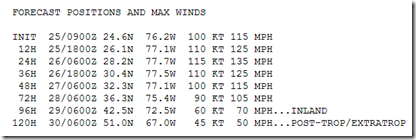
Overnight Irene appears to have undergone an EWRC (Eye Wall Replacement Cycle) which has temporarily weakened the storm slightly.  The 5am discussion from the NHC pegs her sustained winds at no more than 100 knots (115 MPH), but models suggest some additional strengthening is possible.


The intensity of a hurricane is more difficult to forecast than her track, so there is always some degree of uncertainty as to just how powerful a storm will be 48 to 72 hours in the future.


Nevertheless, here are this morning’s estimates from the 5am discussion from the NHC.


image


This morning’s discussion also notes that the official track forecast has been shifted very slightly to the west, and is roughly in the middle of the guidance envelope which is bracketed by the UKMET on the east and the GFDL model on the west.


image

Irene remains a very large and powerful storm, and even if it’s center should manage to stay offshore, it is capable of causing heavy damage and disruption along the eastern seaboard and even into New England.


Interests along the eastern seaboard of the United States should take this threat seriously, even those who live well inland.


Last May National Hurricane Preparedness week was observed, and during that month this blog devoted considerable space to that topic.


A few of my blogs on the subject included:


National Hurricane Preparedness Week 2011

Hurricane Preparedness Week: Inland Flooding

How Not To Be Gone With The Wind

Getting SLOSHed For Hurricane Season


Along with some general preparedness blogs:


When 72 Hours Isn’t Enough

In An Emergency, Who Has Your Back?

An Appropriate Level Of Preparedness


Some essential hurricane preparedness resources include:


http://www.fema.gov/hazard/hurricane/index.shtm


http://www.ready.gov/america/beinformed/hurricanes.html


While some very good information and analysis can be had through non-official channels on the internet, you should only rely on local emergency management officials, the National Hurricane Center, and the National Weather Service for:

  • forecasts
  • warnings
  • evacuation recommendations


That said, you can find some alternative hurricane resources from my blog post called Online Hurricane Resources from last June.

Wednesday, August 24, 2011

Irene Update & And Some Hurricane History


# 5777


Forecasters with the National Hurricane Center now believe that Irene – which is currently battering the Southern Bahamas – is likely to track to the east of Florida and pose a late-week threat to the mid-Atlantic states.


image


There remains some uncertainty about this path, particularly on days 4 and 5, and interests along the Eastern seaboard should not focus on the exact forecast positions displayed.


And as these tropical systems gain latitude, they often pick up forward speed – which can enhance the effects of their winds – and they usually expand in size as well.


Meaning that even if the center of Irene stays off shore, the storm could still produce serious effects along the Eastern Seaboard.


Irene weakened slightly yesterday, but has regained CAT 2 strength.  Conditions favor the storm intensifying and it is forecast to become a major hurricane later today.


Hurricanes are not just a Southern concern.


While hurricanes do tend to lose intensity as they traverse over the cooler waters of the North Atlantic, very strong storms have made it as far north as New England.


The New England Hurricane of 1938 was a strong CAT 3 storm and produced gusts of CAT 5 strength over parts of Connecticut, Rhode Island and southern Massachusetts including Cape Cod. It was responsible for hundreds of deaths and great destruction.


image

1938 New England Hurricane – Credit Wikipedia


Six years later the Great Atlantic Hurricane of 1944 brushed Cape Hatteras before making landfall as a CAT 1 hurricane on Long Island.  It caused heavy damage in North Carolina, and along the Jersey Shore.


image

1944 Great Atlantic Hurricane – Credit Wikipedia


And in August of 1954, Hurricane Carol struck as a Category 2 affecting southeast Rhode Island and south coastal Massachusetts.

image

1954 Hurricane Carol – Credit Wikipedia


Two weeks later, Hurricane Edna – a CAT 1 storm at landfall – hit Cape Code, Martha’s Vineyard, and caused heavy damage in Maine.


image

1954 Hurricane Edna– Credit Wikipedia


Other notable hurricanes that have impacted New England include Donna in 1960,  Gloria in 1985, and Bob in 1991.


It has been 20 years since the last hurricane made a New England landfall, although a number of weaker tropical storms have impacted the region.


Many residents have therefore become complacent, believing that these storms are unlikely to pack a punch when they arrive.


But as the Great Hurricane of 1938 (aka `The Long Island Express’), the Great Atlantic Hurricane of 1944, the double strike of Carol and Edna in 1954, and Hurricane Donna in 1960 prove  . . .  New England cannot claim immunity to destructive hurricanes.


No matter where you live, NOW is the time to review your emergency plan, including where you will go if you are ordered to evacuate, and to make any last minute additions to your emergency kit.


If you live in Hurricane country, the National Hurricane Center website should be your primary source of forecast information, but if you are on Twitter, you should also follow @FEMA, @CraigatFEMA, @NHC_Atlantic, @NHC_Pacific and @ReadydotGov for the latest Emergency information.


To become better prepared as an individual, family, business owner, or community to deal with hurricanes, tornadoes, floods, or any other type of disaster: visit the following preparedness sites.


FEMA http://www.fema.gov/index.shtm

READY.GOV http://www.ready.gov/

AMERICAN RED CROSS http://www.redcross.org/

Tuesday, August 23, 2011

Irene Takes Aim At The Bahamas


image

Photo Credit NOAA GOES East


# 5773


Having avoided crossing the mountainous terrain of Hispaniola, Hurricane Irene continues to intensify and move towards the Bahamas as a CATAGORY 2 storm. 


Model guidance has finally consolidated, and for now the news is much improved for Florida and the Gulf of Mexico, but not so good for those residing further up the Eastern seaboard.


But first, Irene is expected to move across the entire length of the Bahamas as a major hurricane.

image


Although most of Florida is now out of the forecast track, the NHC  reminds the public not to focus on the exact forecast track . . . especially at days 4 and 5 . . . since the most recent 5-year average errors at those forecast times are 200 and 250 miles respectively.


Since this forecast track could change further, it is important for all interests along the Atlantic seaboard to follow the National Hurricane Center’s tracking of this storm.


For now, the thinking is that Irene will become an unusually large storm, with Category 3 winds, and that it will likely cross the Bahamas over the next 48 hours and threaten the coastline from Georgia north to Virginia over the weekend.


image

From the 8/23 5am NHC Discussion

Those residing even hundreds of miles from the forecast track may experience significant effects from this storm, including high winds and heavy rains - and along the coast - beach erosion and rip currents.


The latest Tropical Storm Force Wind Probabilities map includes a good sized chunk of the Southeast.

image


And even those living hundreds of miles inland need to be paying attention to this storm, as I wrote in You Don’t Have To Live On The Coast, inland flooding can be a major cause of death and destruction from these landfalling hurricanes.

image

Tornadoes can spin up from these landfalling systems, often hundreds of miles inland, as well. 


As always, the National Hurricane Center website should be your primary source of forecast information, but if you are on Twitter, you should also follow @FEMA, @CraigatFEMA, @NHC_Atlantic, @NHC_Pacific and @ReadydotGov for the latest Emergency information.


To become better prepared as an individual, family, business owner, or community to deal with hurricanes, tornadoes, floods, or any other type of disaster: visit the following preparedness sites.


FEMA http://www.fema.gov/index.shtm

READY.GOV http://www.ready.gov/

AMERICAN RED CROSS http://www.redcross.org/

Sunday, August 21, 2011

Irene Targets Caribbean As Florida Waits


# 5767


Tropical Storm Irene, the 9th named storm of the 2011 Atlantic Tropical season, formed several hundred miles east of the Lesser Antilles late yesterday and is now lashing the Northern Leeward Islands with squalls and heavy rains.


It’s forecast path puts Puerto Rico, the island of Hispaniola, and Cuba under the gun over the next 96 hours, and most models have it posing a threat to South Florida five days from now.


image The solid white area depicts the track forecast uncertainty for days 1-3 of the forecast, while the stippled area depicts the uncertainty on days 4-5.


Forecasts can change, and the cone of uncertainty is hundreds of miles wide 5 days out. Still, Floridians need to be making plans now for how they will deal with Irene should she come our way.


For the beleaguered residents of Haiti and the Dominican Republic, this will be the second tropical system to visit in less than a month. You’ll recall that a disheveled T.S. Emily dropped more than 20 inches of rain on parts of that island earlier this month, causing heavy flooding and several fatalities.


Conditions are somewhat better now for storm intensification, and Irene is forecast to reach hurricane strength before crossing the coastline of Hispaniola . . .  either late Monday or early Tuesday.


The mountainous terrain of Hispaniola and Cuba are both famous for taking the punch out of tropical systems, and so Irene’s strength after passing these natural barriers is likely to be somewhat diminished.


How much, and how well can it recover once back over the warm waters of the Florida straits, is the question on a lot of Floridian’s minds right now.


The 5am discussion from the National Hurricane Center suggests that Irene will likely regain hurricane strength rapidly after clearing the islands of the Caribbean.


THE UPPER-LEVEL ENVIRONMENT IS EXPECTED TO BE QUITE FAVORABLE FOR STRENGTHENING THROUGHOUT THE FORECAST PERIOD AS A RESULT OF LOW SHEAR AND A MID-OCEANIC TROUGH TO THE EAST ACTING AS A MASS SINK
FOR THE OUTFLOW IN THE EASTERN SEMICIRCLE. 


HOWEVER...THE INTENSITY FORECAST IS HEAVILY DEPENDENT ON HOW MUCH INTERACTION IRENE HAS WITH THE MOUNTAINOUS TERRAIN OF HISPANIOLA AND WHAT THE INNER CORE OF THE CYCLONE BECOMES AFTER IT EMERGES OFF THE NORTHEAST COAST OF CUBA IN ABOUT 4 DAYS.


ONCE OVER THE FLORIDA STRAITS...HOWEVER...  IRENE WILL HAVE AT LEAST 24 HOURS OVER SOME OF THE WARMEST WATER IN THE ATLANTIC TO TAP INTO. THE OFFICIAL FORECAST REMAINS ON THE CONSERVATIVE SIDE DUE TO LAND EFFECTS AND IS CLOSE TO A BLEND OF SHIPS AND LGEM STATISTICAL INTENSITY MODELS.


FORECAST POSITIONS AND MAX WINDS

INIT  21/0900Z 16.4N  61.3W   45 KT  50 MPH
12H  21/1800Z 17.0N  63.7W   50 KT  60 MPH
 24H  22/0600Z 17.5N  66.7W   60 KT  70 MPH
36H  22/1800Z 18.0N  69.2W   70 KT  80 MPH
48H  23/0600Z 18.6N  71.5W   50 KT  60  MPH  ... INLAND

72H  24/0600Z 20.3N  75.3W   50 KT  60 MPH... INLAND
96H  25/0600Z 22.8N  78.2W   60 KT  70 MPH... OVER WATER
120H  26/0600Z 26.1N  80.7W   75 KT  85   MPH  ... INLAND
 

With the exception of the UKMET and GFDL models, most of the computer runs are in close agreement as to the future path of Irene. 


image


A Hurricane watch has been issued for Puerto Rico and surrounding islands, and it seems likely that Hispaniola will be dealing with a strong tropical storm or minimal hurricane in less than 48 hours where flooding and mudslides are always a major concern.  


There also remain tens thousands of people who still live in scores of flimsy tent-and-tarp settlements that sprang up after Haiti’s 7.0 Earthquake in early 2010.


For Haiti, and to a lesser extent the Dominican Republic, heavy rains may further exacerbate their recent Cholera outbreaks, and could also help increase the number of mosquitoes that carry Dengue fever.


Other Interests in the Caribbean, and in the Southern United States, need to keep track of this storm’s progress as well.  As always, the National Hurricane Center is your best source of information.  


If you are on Twitter, you should also follow @FEMA, @CraigatFEMA, @NHC_Atlantic, @NHC_Pacific and @ReadydotGov.


NOAA’s NWS National Hurricane Center in Miami also has a Facebook page, where you can keep up with the latest tropical developments.


 image


Of course, knowing about an approaching storm is important, but you need to be prepared as well.


To help you along, NOAA, FEMA, and the American Red Cross have released an updated preparedness guide for the 2011 tropical season.


image