Showing posts with label NHC. Show all posts

Monday, May 25, 2015

Storm Surge Monday – Hurricane Preparedness Week

 image

Crystal Beach, Tx after Hurricane Ike (2008) showing destructive force of storm surge

# 10,088


This is day two of 2015’s National Hurricane Preparedness Week and the focus today is on Storm Surge, often the biggest cause of death from these killer storms.  While we usually worry most about the winds surrounding the eye of a hurricane, storm surge is more dependent on the contour of the coast, the storm’s angle of approach, and the forward speed of the storm.


Often the highest surge is well away from where the eye crosses the coastline, which can catch some coastal residents off guard.


This year the National Hurricane Center will be introducing a new experimental forecast product designed to warn coastal residents of areas where dangerous storm surges are expected.   Full implementation of this product is not expected until 2017.


National Hurricane Center to issue storm surge watch and warning graphic

image


Beginning with the 2015 hurricane season, NOAA’s National Hurricane Center (NHC) will offer an experimental storm surge watch/warning graphic to highlight those areas along the Gulf and Atlantic coasts of the United States that have a significant risk of life-threatening inundation by storm surge from a tropical cyclone.


The new graphic is designed to introduce the concept of a watch or warning specific to the storm surge hazard. Storm surge is often the greatest threat to life and property from a tropical cyclone, and it can occur at different times and at different locations from a storm’s hazardous winds. In addition, while most coastal residents can remain in their homes and be safe from a tropical cyclone’s winds, evacuations are generally needed to keep people safe from storm surge. Having  separate warnings for these two hazards should provide emergency managers, the media, and the general public better guidance on the hazards they face when tropical cyclones threaten.

(Continue . . . )


Next  stop, a short video from the NHC (National Hurricane Center), and a NHC description of storm surge, after which I’ll return with a bit more:

image

Storm Surge vs. Storm Tide
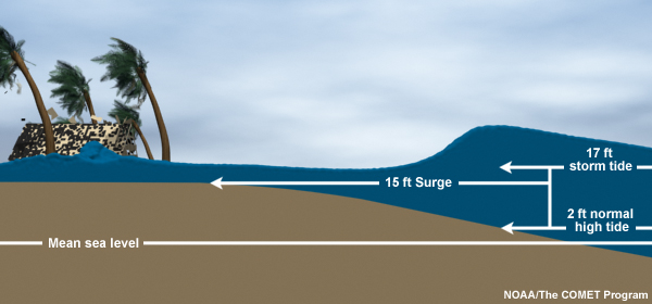
Storm surge is an abnormal rise of water generated by a storm, over and above the predicted astronomical tides. Storm surge should not be confused with storm tide, which is defined as the water level rise due to the combination of storm surge and the astronomical tide. This rise in water level can cause extreme flooding in coastal areas particularly when storm surge coincides with normal high tide, resulting in storm tides reaching up to 20 feet or more in some cases.


Storm Surge vs. Storm Tide


Back in 2011,  in Getting SLOSHed For Hurricane Season I wrote about the Sea, Lake and Overland Surges from Hurricanes computer model that emergency planners use to plan for coastal evacuations.  In order to know in advance how far inland a storm surge or tide will encroach, emergency planners run hundreds of SLOSH models for populated regions along the coast. 


image

They vary the size, intensity, direction, and forward speed of hurricanes in the model in order to determine the worst case impact for each category of storm. Evacuation maps and routes are then generated using this information.

image

This evacuation map of Pinellas County (St. Petersburg-Clearwater) Florida shows that a storm even as low as a CAT 3 could temporarily cut the southern half of the county off from the north.


Of course much depends upon the speed, direction, and point of landfall of the storm, and so not all CAT 3 storms impacting this area would produce this dramatic of an effect.


Take it from someone who has experienced more than one of these storm surges first hand . . . if you are asked to evacuate by your local authorities, don’t hesitate.


Just do it.


For more information on the storm’s effects, and how you should prepare, check back every day this week and visit:

image

Wednesday, May 06, 2015

Some Preseason Doings Off The Florida Coast

image


# 10,017


As a Floridian with more than enough hurricane notches in my belt for a lifetime, I always approach the start of the Atlantic Tropical Storm season (June 1st) with a small amount of trepidation. 


While I’ve swallowed the anchor (aka `moved landside’), nothing beats riding through a couple of rowdy tropical storms aboard a small sailboat to instill a lifelong respect for these powerful storms.


image


Rarely, we will  see the development of one of these tropical systems outside the traditional June1st-Nov 31st hurricane season.  May leads the pack with 20 such storms (between 1851-2013), followed by December with 17.  But February, March, and April each have one on record as well.   


Most, thankfully, never reach hurricane strength. Although as anyone who went through the March superstorm of 1993 will attest, having tropical characteristics, a name, and hurricane status are sometimes overrated. 

image

This unnamed system claimed more than 300 lives and inflicted more than $6 billion dollars in damage as it swept out of the Gulf and up the Atlantic Seaboard.


All of which makes it unusual, but not unheard of, that NOAA’s National Hurricane Center finds itself monitoring an area of suspicion – with potential to develop – off the southern coast of Florida.   Interests along the Florida and Southeastern United States Coast are urged to monitor its progress over the next few days.


SPECIAL TROPICAL WEATHER OUTLOOK


NWS NATIONAL HURRICANE CENTER MIAMI FL
800 AM EDT WED MAY 6 2015

For the North Atlantic...Caribbean Sea and the Gulf of Mexico:

Disorganized showers and thunderstorms extending over portions of Florida, the Bahamas, and adjacent waters are associated with an upper-level trough and a weak surface low located over the northwestern Bahamas.  The aircraft reconnaissance mission scheduled for this afternoon has been cancelled.  However, conditions are expected to become gradually more favorable for development over the next day or so while the system moves slowly northward.  A subtropical or tropical cyclone could form by Thursday or Friday, and interests along the southeast coast of the United States should monitor the progress of this system through the weekend. The next Special Tropical Weather Outlook will be issued on this system by 8 PM EDT today. For additional information, see High Seas Forecasts issued by the National Weather Service.

* Formation chance through 48 hours...medium...60 percent
* Formation chance through 5 days...medium...60 percent


We’ll spend a fair amount of time looking at hurricane preparedness during National Hurricane Preparedness Week at the end of May.  Disasters, however, don’t read calendars and so it is always prudent to prepare sooner rather than later.

image

Wednesday, August 20, 2014

NHC: Watching The Tropics

image

NHC 5 Day Experimental Outlook


# 8979


With the caveat that this is 5-day experimental outlook, and that it is far to early in the game to begin thinking about what areas of the United States might be impacted, the National Hurricane Center has nonetheless increased the odds that a disturbance now approaching the Windward Islands will organize into a tropical cyclone to 60% over the next 5 days.


TROPICAL WEATHER OUTLOOK

NWS NATIONAL HURRICANE CENTER MIAMI FL
200 PM EDT WED AUG 20 2014

For the North Atlantic...Caribbean Sea and the Gulf of Mexico:

1. Shower and thunderstorm activity associated with an elongated area of low pressure located several hundred miles east of the Windward Islands has become a little better organized during the past few hours. Additional slow development of this system is possible during the next day or two, and a tropical depression could form as the system moves west-northwestward at 10 to 15 mph across the Lesser Antilles and into the Caribbean Sea. After that time, land interaction could limit development potential over the weekend.

Regardless of tropical cyclone formation, gusty winds and heavy rainfall are possible across portions of the Lesser Antilles, Puerto Rico, and the Virgin Islands on Thursday night and Friday. Interests in those islands should closely monitor the progress of this system. An Air Force Reserve Hurricane Hunter aircraft is scheduled to investigate this system tomorrow afternoon, if necessary. * Formation chance through 48 hours...medium...50 percent. * Formation chance through 5 days...high...60 percent.


While we’ve seen a very slow start to the 2014 Atlantic tropical season, we are only a couple of weeks away from the traditional `peak’ of  Hurricane season,  which means this is the time of year we need to be keeping a `weather eye’ on the tropics.


Although this system won’t pose a threat to the continental United States until at least sometime next week (assuming it does, at all) - if you live in Florida, or anywhere along the Gulf Coast – it is never too early to be thinking about your hurricane preparedness plans.


Interests in the Caribbean, of course, could be impacted much sooner - perhaps later this week or over the weekend. Although there are some early model runs suggesting a likely `path’ for this system, they are of only limited value before a tropical cyclone actually forms, and can easily lull one into complacency.


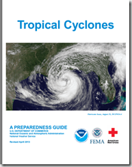
If you haven’t already downloaded the updated Tropical Cyclone Preparedness Guide, now would be an excellent time to do so.

image

NOAA’s NWS National Hurricane Center in Miami are the real experts in hurricane forecasting, and the only ones you should trust. They also have a Facebook page, where you can keep up with the latest tropical developments.

For additional official information you should bookmark your local Office of Emergency Management.  Here you’ll be able to access local warnings, flood maps and evacuation information. To find your local one, you can Google or Yahoo search with your county/parish name and the words `Emergency Management’.  


If you are on Twitter, you should also follow @FEMA, @CraigatFEMA, @NHC_Atlantic, @NHC_Pacific and @ReadyGov. 

And lastly, a shortcut to my `How To Prepare For Hurricane Season’ post for 2014: Hurricane Preparedness Week: Make A Plan

Thursday, July 03, 2014

Hurricane Arthur, July Climatology & NHC’s New 5-Day Graphical Forecast

image


# 8803


Arthur, a category one hurricane, is expected to pass very close to the outer banks of North Carolina this evening on its trek north.  While most of the worst of the weather will likely remain offshore, areas along the coastline are likely to take a pounding. 


image

Residents in the affected areas should be completing their hurricane preparations now (see Hurricane Preparedness Week: Make A Plan).


Storms that form in June and early July generally form in the Caribbean, the Gulf of Mexico, or just off the coast of the United States – as has Arthur. 

June Tropical Climatology

image

Credit NOAA

As the summer progresses the spawning grounds for Hurricanes moves further east into the warming Atlantic ocean.  But it usually isn’t until  August and September that the Cape Verde basin begins to produce what often turn into the largest and most persistent storms.


July & August Tropical Climatology

image


And the number of storms increases as we get later in the summer, with the peak of activity usually in the first half of September.  Hurricane season lasts through November 30th, however, and so late season storms are always possible.

image


You can find much more on Hurricane Climatology at NOAA’s  Tropical Cyclone Climatology page.

When it comes to getting the latest information on hurricanes, your first stop should always be the National Hurricane Center in Miami, Florida. These are the real pros, and the only ones you should rely on to track and forecast the storm.

  • Tropical storm watches will be issued when tropical storm conditions are possible along the coast within 48 hours.
  • Tropical storm warnings will be issued when those conditions are expected within 36 hours. Similar increases in lead-time will apply to hurricane watches and warnings.


This year the NHC has also introduced a new five-day graphical forecast, showing the areas of the tropics where tropical development is possible (or expected) over the next 120 hours.   Here is how NOAA describes this new feature:


Five-Day Graphical Tropical Weather Outlook Introduced


Beginning at 2 p.m. EDT July 1st , NOAA’s National Hurricane Center (NHC) will introduce an experimental five-day Graphical Tropical Weather Outlook (GTWO) to accompany its text Tropical Weather Outlook (TWO).


The new five-day GTWO, available for both the Atlantic and eastern North Pacific basins, will indicate the formation potential of  current and future disturbances during the next five days.

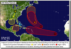
Shaded areas will represent the potential tropical cyclone  formation areas,  color-coded by development likelihood, with yellow representing a low (<30%) chance, orange denoting a medium (30%  to 50%) chance, and red  corresponding to a high (>50%) chance of tropical cyclone formation during the next five days. The location of each current disturbance will be denoted by an “X”. A mouse-over feature will allow users to see the accompanying Outlook text for each system. Clicking on an area will display a graphic showing only that disturbance, which should improve clarity when the forecast genesis areas overlap. Because the new five-day GTWO will tend to be busier than the current 48-hour GTWO, the five-day graphic will not display the locations of existing tropical cyclones.


Here is an example of the new five-day GTWO:

 image


For now, with the exception of Arthur, the Atlantic Basin and Caribbean are quiet, with no tropical development expected.

image


Making this 4th of July weekend a good time to go over your hurricane (and other disaster) preparedness plans, making sure you, your family, and your business are prepared to deal with whatever unexpected situation that life, and nature, can throw at you.


In addition to the preparedness information you can find on the FEMA and READY.GOV websites, a few of my earlier preparedness blogs include:


 When 72 Hours Isn’t Enough

The Gift Of Preparedness: 2013

In An Emergency, Who Has Your Back?

Thursday, May 29, 2014

Hurricane Preparedness Week: Forecasting Then & Now

 image


# 8679


For those born after 1960, it is probably hard to understand just how vulnerable we used to be to the unannounced arrival of hurricanes and tropical storms.  Before then, we had no `eyes in the skies’ –  weather satellites – to tell us if something was brewing far offshore, and tracking storms was pretty much hit and miss, based on ship’s reports.  


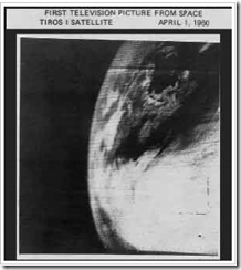
All that uncertainty began to change, when on April 1st 1960 Tiros I - the world's first weather satellite - was launched into Earth orbit from Cape Canaveral, Florida.


For the first time, we had a `god's eye view' of earth, and while the pictures were grainy, and the resolution laughable by today's standards, we could finally watch how and where hurricanes formed. It was a wondrous day for everyone, except possibly for members of the Flat Earth Society.

image

The first weather satellite photo from space.


It meant we were no longer solely dependent on ship's reports and Hurricane Hunter aircraft to know if disaster lay just beyond the horizon. It meant more than 12 hours warning to prepare for a storm.  And it was a major step in unraveling the mysteries of cyclone genesis.


It would take time of course. The first satellite only produced about 1 picture an hour, and then, only during daylight hours. Infrared capability was added in later `birds’.  For those with in interest in how `old school’ forecasting was accomplished, last year I wrote about a legend: Grady Norton: The First Hurricane Forecaster.


image

Three different views from space, taken May 26th, 2011 1345Z – NOAA

Today, our reconnaissance satellites can take 40 pictures an hour, and see right through the clouds and measure rainfall, winds and even sea water temperatures.Add in the power of supercomputers,ocean buoys, hurricane probes, and five decades of new knowledge, and the art of hurricane forecasting has improved tremendously over the past 50 years.


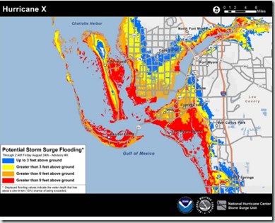
This year, forecasts will include even more information – particularly for coastal residents – as we discussed on Sunday. This year, the NHC will be issuing enhanced color-coded experimental Potential Storm Surge Flooding Maps showing the locations that could be affected by storm surge based on their (SLOSH) computer models.


Of course, all of the advances in forecasting technology are for naught if people don’t use this information to prepare for – and in some cases, get out of the way of – these storms.


Which is why tomorrow and Saturday Hurricane Preparedness Week will focus on what you need to do to get ready for the storm.


In the meantime, if you haven’t already, now would be a good time to download the updated Tropical Cyclone Preparedness Guide and to think about what hazards your home, and or business, might face if one of these storms pays a visit this summer or fall.

image

Sunday, May 25, 2014

Hurricane Preparedness Week 2014 – Day 1

image


# 8662


Live along the Atlantic or Gulf coastline long enough, and the odds say you’ll eventually be impacted by an Atlantic hurricane or tropical storm. As a native Floridian - I’ve seen more than a few - which is why  I give hurricane preparedness a prominent place in this blog each year. 


Well over 50 million Americans live in susceptible coastal areas, while further inland many more are susceptible to inland flooding and spinoff tornadoes. 

image

From Escambia County Hurricane Preparedness Information

And while the tropical threat to Mexico, Central America, and the Caribbean islands is well known, a recent study (see Nature  The poleward migration of the location of tropical cyclone maximum intensity) suggests the hurricane threat may be increasing for higher latitudes.   This from NOAA News.


NOAA-led study: Tropical cyclone 'maximum intensity' is shifting toward poles

Researchers find that the average latitude where tropical cyclones achieve maximum intensity has been shifting poleward since 1980

May 14, 2014

Typhoon Francisco and Super Typhoon Lekima on October 23, 2013 as they tracked northwestward toward China and Japan. (Credit: Tim Olander and Rick Kohrs, SSEC/CIMSS/UW-Madison, based on Japan Meteorological Agency data.)

Typhoon Francisco and Super Typhoon Lekima on October 23, 2013 as they tracked northwestward toward China and Japan. (Credit: Tim Olander and Rick Kohrs, SSEC/CIMSS/UW-Madison, based on Japan Meteorological Agency data.)

Over the past 30 years, the location where tropical cyclones reach maximum intensity has been shifting toward the poles in both the northern and southern hemispheres at a rate of about 35 miles, or one-half a degree of latitude, per decade according to a new study, The Poleward Migration of the Location of Tropical Cyclone Maximum Intensity, published tomorrow in Nature.

As tropical cyclones move into higher latitudes, some regions closer to the equator may experience reduced risk, while coastal populations and infrastructure poleward of the tropics may experience increased risk. With their devastating winds and flooding, tropical cyclones can especially endanger coastal cities not adequately prepared for them. Additionally, regions in the tropics that depend on cyclones' rainfall to help replenish water resources may be at risk for lower water availability as the storms migrate away from them.

(Continue . . .)


All this week we’ll be talking about the different types of hurricane threats, and what you should be doing now to prepare for them.  


While later this week we’ll look at hurricane winds, surge, and flooding, and preparedness today we’ll focus on some of the ways that this year’s hurricane forecasts will change.  


Five prominent changes are described in a NOAA release called Update on NHC Products and Services for 2014 (PDF).


The biggest change will be the inclusion of a color-coded experimental Potential Storm Surge Flooding Map showing the locations that could be affected by storm surge based on their Sea, Lake and Overland Surges from Hurricanes (SLOSH) computer model.


image


We looked at this forecasting tool back in 2011 in Getting SLOSHed For Hurricane Season.


Other changes this year:


The Tropical Weather Outlook (TWO) and Graphical Tropical Weather Outlook (GTWO) will both be extended to a 5-day outlook. The TWO and GTWO products are issued at 2 a.m., 8 a.m., 2 p.m., and 8 p.m. Eastern Daylight Time.

  image


While forecast tracking of Hurricanes has improved considerably over the years, less progress has been made in predicting intensities 12, 24, 48, and 72 hours out.


So gone this year will be the The Wind Speed Probability product which showed the likelihood that a tropical cyclone would be at any one of several different wind speed categories over the next three days. 


The concern was people were basing their evacuation/preparation decisions on a model that the NHC  describes as being accurate, but in some cases could provide  `a highly misleading estimate of landfall intensity’.  


A relief to all those who see  `all-caps’ text messaging as `shouting’, the NHC will implement a more eye-friendly standard for their Tropical Weather Outlook and the Tropical Cyclone Discussion using mixed case, as well as with the full set of standard punctuation symbols.  No formatting changes are planned for other NHC advisory products at this time.


And lastly, as a further indication that hurricane track forecasts continue to improve, the 2014 Tropical Cyclone forecast cone will be slightly smaller for 72 hours out, and beyond.  Not a big change, but a hopeful trend.


When it comes to getting the latest information on hurricanes, your first stop should always be the National Hurricane Center in Miami, Florida. These are the real pros, and the only ones you should rely on to track and forecast the storm.

  • Tropical storm watches will be issued when tropical storm conditions are possible along the coast within 48 hours.
  • Tropical storm warnings will be issued when those conditions are expected within 36 hours. Similar increases in lead-time will apply to hurricane watches and warnings.


NOAA’s NWS National Hurricane Center in Miami also has a Facebook page, where you can keep up with the latest tropical developments.


The second official information source you should have bookmarked is your local Office of Emergency Management.  Here you’ll be able to access local warnings, flood maps and evacuation information. To find your local one, you can Google or Yahoo search with your county/parish name and the words `Emergency Management’.  


If you are on Twitter, you should also follow @FEMA, @CraigatFEMA, @NHC_Atlantic, @NHC_Pacific and @ReadyGov. 


We all hope that the 2014 tropical season will be as non-eventful as last year, but no one can predict what may waltz up out of the tropics this summer.  


As I wrote a week ago (see NOAA: 2014 Atlantic Hurricane Outlook), 1992 was a `quiet’ year for hurricanes – as long as you don’t count Category 5 hurricane Andrew . . . 


Which is why preparedness – not hope -  is your best insurance against an uncertain, and potentially dangerous, hurricane season.

Thursday, August 15, 2013

NPM13: A Tropical Wake Up Call

image


# 7574


Ten weeks into the 2013 Atlantic Tropical season and we are starting to see signs of increased activity, with a new tropical storm (Erin) far out in the Atlantic, and an area of disturbed weather with a high probability of development closer to home.


Last week both NOAA and Dr. William Gray reiterated their forecasts for a busy remainder of the tropical season (see NOAA: Above Average Atlantic Hurricane Season Still Expected).


Erin, a Cape Verde storm, is forecast to maintain its westerly motion for the next five days, and could pose a threat to the Caribbean late next week.

image


The disturbance in the western Caribbean is expected to move into the southern Gulf of Mexico, and has a greater than 50/50 chance of becoming a tropical storm over the next few days.


Regardless of how these two systems play out, we’ve still got 3-1/2 months of Hurricane season ahead of us.


Which is why, in a little over two weeks – AFD - along with thousands of other coalition members, will devote a good deal of time and attention to Ready.gov & Fema’s annual National Preparedness Month; urging individual, family, community and business preparedness efforts.


image_thumb1


As you can see by the chart above, the number of coalition members has quadrupled since 2010.


Members consist of individuals, organizations, and businesses . . . and you are encouraged to join as well.


For those who equate prepping with sensationalized cable TV `Doomsday-type’ preppers, allow me to reassure you that you needn’t dig a bunker, accumulate a small armory, or lay in a 20 year’s worth of freeze-dried food in order to be prepared.


image

Basic Preps: Emergency Weather Radio, First Aid Kit, Battery Lantern, Water storage – Add some food (3-10 day supply), and an emergency plan, and you are well on your way to being prepared. 


The goal of NPM2013 is to foster a culture of national preparedness, and to encourage everyone to plan and be prepared to deal with an event where they can go at least three days without electricity, running water, local services, or access to a supermarket.


These are, of course, minimum goals.


The disruptions following hurricanes, tornado outbreaks, floods, and other natural disasters can potentially last for days or even weeks, and so – if you are able to do so - being prepared for 10 days to 2 weeks makes a good deal of sense (see When 72 Hours Isn’t Enough).


As a Floridian, my preparedness plans are somewhat hurricane-centric, as these massive storms provide the most likely disaster scenario for my area.  But my disaster plans are appropriate for other disaster scenarios as well.


In addition to being prepared to shelter-in-place for up to two weeks, I have a network of trusted disaster buddies to whom I can turn in an emergency (as can they to me), several pre-arranged evacuation destinations should I need to `get out of Dodge’, and a 72-hour bug-out bag I can grab at a moment’s notice.

bob 001a

My Bug-out-bag, Canteen, & Toiletry kit

I also keep an overnight bag, and a fully equipped first aid kit, in the trunk of my car . . .  just in case (see Inside My Auto First Aid Kit).


While the federal government will respond during any major disaster, they know it may take days or longer to reach everyone and to restore essential services. Which is why they encourage all individuals, families, business owners, and communities to become better prepared to deal with all types of disasters.


I would invite you visit the following preparedness sites.


FEMA http://www.fema.gov/index.shtm

READY.GOV http://www.ready.gov/

AMERICAN RED CROSS http://www.redcross.org/


If you are on Twitter, I would recommend you follow @FEMA, @CraigatFEMA, @NHC_Atlantic, @NHC_Pacific and @ReadyGov.

And finally, a few of my own preparedness articles include:


In An Emergency, Who Has Your Back?

An Appropriate Level Of Preparedness

The Gift of Preparedness 2012

Thursday, August 08, 2013

NOAA: Above Average Atlantic Hurricane Season Still Expected

image

The peak of the hurricane season is still ahead - Photo Credit NOAA


# 7553


Although the first two months of the 2013 Altantic Tropical season have been fairly uneventful (4 tropical storms, no hurricanes), there are still four months left to go, and NOAA continues to see conditions ripe for an above-average tropical season.


Earlier this month, we saw similar predictions from Colorado State University’s Dr. William Gray: August Hurricane Forecast Update.


Here is the latest prediction from NOAA.


NOAA: Atlantic hurricane season on track to be above-normal

August 8, 2013

 Image of Tropical Storm Dorian on July 24, 2013 from NOAA's GOES East satellite.

Image of Tropical Storm Dorian on July 24, 2013, from NOAA's GOES East satellite.

High resolution (Credit: NOAA)

NOAA issued its updated Atlantic hurricane season outlook today saying the season is shaping up to be above normal with the possibility that it could be very active. The season has already produced four named storms, with the peak of the season – mid-August through October – yet to come.

“Our confidence for an above-normal season is still high because the predicted atmospheric and oceanic conditions that are favorable for storm development have materialized,” said Gerry Bell, Ph.D., lead seasonal hurricane forecaster at NOAA’s Climate Prediction Center, a division of the National Weather Service. “Also, two of the four named storms to-date formed in the deep tropical Atlantic, which historically is an indicator of an active season.”


The conditions in place now are similar to those that have produced many active Atlantic hurricane seasons since 1995, and include above-average Atlantic sea surface temperatures and a stronger rainy season in West Africa, which produces wind patterns that help turn storm systems there into tropical storms and hurricanes.


The updated outlook calls for a 70 percent chance of an above-normal season. Across the Atlantic Basin for the entire season – June 1 to November 30 – NOAA’s updated seasonal outlook (which includes the activity to date of tropical storms Andrea, Barry, Chantal, and Dorian) projects a 70 percent chance for each of the following ranges:

  • 13 to 19 named storms (top winds of 39 mph or higher), including
    • 6 to 9 hurricanes (top winds of 74 mph or higher), of which
    • 3 to 5 could be major hurricanes (Category 3, 4 or 5; winds of at least 111 mph)

These ranges are above the 30-year seasonal averages of 12 named storms, six hurricanes and three major hurricanes.

(Continue . . . )


If you haven’t already downloaded the Tropical Cyclone Preparedness Guide, now would be an excellent time to do so. It is a short (12-page), easy to follow guide that will walk you through the basics of understanding (and surviving) hurricanes and tropical storms.

image


For more on hurricane preparedness you may wish to revisit:


Hurricane Preparedness Week: Day 6 & 7

Grady Norton: The First Hurricane Forecaster

Hurricane Preparedness Week: Inland Flooding

Hurricane Preparedness Week & The Tale Of The Tape

Storm Surge Monday

National Hurricane Preparedness Week – Day 1

Monday, July 29, 2013

August Tropical Climatology

image

Photo Credit NOAA 


# 7523


Mariner’s Poem On Hurricanes

June too soon.
July stand by.
August look out you must.
September remember.
October all over.

- Published in “Weather Lore” by R. Inwards in 1898


As a native Floridian, and a long-time boater, I’m used to keeping a weather-eye out year round. But come the 1st of August my attention grows keener, and my gaze moves eastward, as the next three months are historically the time when the Atlantic produces the most dangerous tropical activity.


As you can see by the chart at the top of this post, the peak of the hurricane season comes in the second week of September, and then slowly tapers off.


Hurricanes are driven by the heat of the oceans, and so they tend to form over the shallower Caribbean and Gulf waters – which heat up fastest in the summer – first.  The map below shows the areas likely to produce tropical systems in June.


image


By early August, the deeper waters of the eastern and middle Atlantic have soaked up enough heat to make them fertile breeding grounds as well.  These storms are also likely to be stronger, and longer lasting.  


image


This morning finds the Atlantic basin fairly quiet, with only the remnants of T.S. Dorian – which sputtered and died last week on its way across the Atlantic – given a 50% chance of resurrection.


image

Credit NHC  Jul 29th, 2013


But as we saw last May, NOAA: Expects An Active Hurricane Season Ahead. Their prediction:


NOAA’s Atlantic Hurricane Season Outlook says there is a 70 percent likelihood of 13 to 20 named storms (winds of 39 mph or higher), of which 7 to 11 could become hurricanes (winds of 74 mph or higher), including 3 to 6 major hurricanes (Category 3, 4 or 5; winds of 111 mph or higher).


This year’s relatively slow start to the hurricane season tells us very little about the months ahead. Horrific Category 5 hurricane Andrew in 1992 – the first named storm of that season – didn’t show up until mid-August.


When it comes to getting the latest information on hurricanes, your first stop should always be the National Hurricane Center in Miami, Florida. These are the real pros, and the only ones you should rely on to track and forecast the storm.


  • Tropical storm watches will be issued when tropical storm conditions are possible along the coast within 48 hours.
  • Tropical storm warnings will be issued when those conditions are expected within 36 hours. Similar increases in lead-time will apply to hurricane watches and warnings.


NOAA’s NWS National Hurricane Center in Miami also has a Facebook page, where you can keep up with the latest tropical developments.


The second official information source you should have bookmarked is your local Office of Emergency Management.  Here you’ll be able to access local warnings, flood maps and evacuation information.


To find your local one, you can Google or Yahoo search with your county/parish name and the words `Emergency Management’.  


If you are on Twitter, you should also follow @FEMA, @CraigatFEMA, @NHC_Atlantic, @NHC_Pacific and @ReadyGov. 


If you haven’t already downloaded the Tropical Cyclone Preparedness Guide, now would be an excellent time to do so. It is a short (12-page), easy to follow guide that will walk you through the basics of understanding (and surviving) hurricanes and tropical storms.

image


Although September is National Preparedness Month, those who potentially live in the path of these storms (and that can be hundreds of miles inland) are urged every year to prepare in May, during National Hurricane Preparedness Week.


image


Some of my blogs on getting ready for this year’s tropical season include:


Hurricane Preparedness Week: Day 6 & 7

Grady Norton: The First Hurricane Forecaster

Hurricane Preparedness Week: Inland Flooding

Hurricane Preparedness Week & The Tale Of The Tape

Storm Surge Monday

National Hurricane Preparedness Week – Day 1

Monday, July 08, 2013

Watching The Tropics


image


# 7458


Although it doesn’t currently pose a threat to the U.S. mainland, Tropical Storm Chantal formed overnight about 1200 km to the ESE of Barbados, and is moving rapidly (26 MPH) towards the West.


The National Hurricane Center (NHC) should always be your primary source of information on tropical threats. In addition to visiting their website, they issue alert via  two Twitter accounts, one for the Atlantic basin (which includes the Gulf of Mexico and the Caribbean Sea):

Follow NHC_Atlantic on Twitter U.S. National Hurricane Center (Atlantic) - @NHC_Atlantic

and one for the Eastern North Pacific basin:

Follow NHC_Pacific on Twitter U.S. National Hurricane Center (Eastern Pacific) - @NHC_Pacific

In addition to the Twitter notifications, NHC also provides product notifications by email. Please visit hurricanes.gov/signup.shtml to sign up for this service.

And if you aren’t already following

FEMA

CraigAtFEMA

Ready.gov

Red Cross

on twitter, you might want to add them to your list.


Here is the latest advisory from the NHC.


BULLETIN


TROPICAL STORM CHANTAL INTERMEDIATE ADVISORY NUMBER   2A


NWS NATIONAL HURRICANE CENTER MIAMI FL       AL032013
800 AM AST MON JUL 08 2013

...CHANTAL MOVING QUICKLY TOWARD THE LESSER ANTILLES...

SUMMARY OF 800 AM AST...1200 UTC...INFORMATION
----------------------------------------------
LOCATION...10.6N 50.6W
ABOUT 630 MI...1010 KM ESE OF BARBADOS
MAXIMUM SUSTAINED WINDS...40 MPH...65 KM/H
PRESENT MOVEMENT...W OR 280 DEGREES AT 26 MPH...43 KM/H
MINIMUM CENTRAL PRESSURE...1007 MB...29.74 INCHES

WATCHES AND WARNINGS
--------------------
CHANGES WITH THIS ADVISORY...

NONE.

SUMMARY OF WATCHES AND WARNINGS IN EFFECT...

A TROPICAL STORM WARNING IS IN EFFECT FOR...
* BARBADOS
* DOMINICA
* SAINT LUCIA
* MARTINIQUE
* GUADELOUPE

A TROPICAL STORM WATCH IS IN EFFECT FOR...
* SAINT VINCENT

A TROPICAL STORM WARNING MEANS THAT TROPICAL STORM CONDITIONS ARE
EXPECTED SOMEWHERE WITHIN THE WARNING AREA...IN THIS CASE WITHIN
24 TO 36 HOURS.

A TROPICAL STORM WATCH MEANS THAT TROPICAL STORM CONDITIONS ARE
POSSIBLE SOMEWHERE IN THE WATCH AREA...IN THIS CASE WITHIN 24 HOURS.

INTERESTS ELSEWHERE IN THE EASTERN CARIBBEAN SHOULD MONITOR THE
PROGRESS OF CHANTAL.

FOR STORM INFORMATION SPECIFIC TO YOUR AREA...PLEASE MONITOR
PRODUCTS ISSUED BY YOUR NATIONAL METEOROLOGICAL SERVICE.

DISCUSSION AND 48-HOUR OUTLOOK
------------------------------
AT 800 AM AST...1200 UTC...THE CENTER OF TROPICAL STORM CHANTAL WAS
LOCATED NEAR LATITUDE 10.6 NORTH...LONGITUDE 50.6 WEST. CHANTAL IS
MOVING TOWARD THE WEST NEAR 26 MPH...43 KM/H...AND A WEST-
NORTHWESTWARD MOTION AT ABOUT THE SAME FORWARD SPEED IS EXPECTED
OVER THE NEXT COUPLE OF DAYS.  ON THE FORECAST TRACK...THE CENTER
OF CHANTAL SHOULD REACH THE LESSER ANTILLES EARLY TUESDAY...AND MOVE
INTO THE EASTERN CARIBBEAN SEA LATER ON TUESDAY.

MAXIMUM SUSTAINED WINDS REMAIN NEAR 40 MPH...65 KM/H...WITH HIGHER
GUSTS.  SOME INCREASE IN STRENGTH IS FORECAST DURING THE NEXT 48
HOURS.

TROPICAL-STORM-FORCE WINDS EXTEND OUTWARD UP TO 60 MILES...95 KM
FROM THE CENTER.

THE ESTIMATED MINIMUM CENTRAL PRESSURE IS 1007 MB...29.74 INCHES.

HAZARDS AFFECTING LAND
----------------------
WIND...TROPICAL STORM CONDITIONS ARE EXPECTED WITHIN THE WARNING
AREA BY EARLY TUESDAY.  TROPICAL STORM CONDITIONS ARE POSSIBLE IN
THE WATCH AREA BY EARLY TUESDAY.

RAINFALL...CHANTAL IS EXPECTED TO PRODUCE RAIN ACCUMULATIONS OF 2 TO
4 INCHES OVER THE LEEWARD AND WINDWARD ISLANDS...WITH MAXIMUM
AMOUNTS OF 6 INCHES POSSIBLE.

Thursday, June 06, 2013

An Early Tropical Reminder

image

 NHC 5am position


# 7367


The rains here have been torrential for several hours, and a large limb has come down next to my house, but so far the worst of Tropical Storm Andrea remains offshore to my west, headed for a landfall later today.


This time yesterday morning, Andrea was little more than a glob of disorganized clouds and rain off the Yucatan peninsula, given a mere 30% chance of development.


By a little after 5pm last night, Andrea had a name, and this morning she is a 60MPH storm.


image


While Andrea will probably be mostly a rain producer, there is always the possibility of some wind damage, coastal storm tides, and even a tornado or two spinning off.  So while not a major storm, Andrea should still be taken seriously.


NOAA has forecast an above average Atlantic Tropical Season, and so Andrea serves as fair warning to all who live within reach of these storms (and that can be hundreds of miles inland) to be prepared this summer.


Last week was Hurricane Preparedness Week, and you may wish to revisit some of my blogs on getting ready for this year’s tropical season.


Hurricane Preparedness Week: Day 6 & 7

Grady Norton: The First Hurricane Forecaster

Hurricane Preparedness Week: Inland Flooding

Hurricane Preparedness Week & The Tale Of The Tape

Storm Surge Monday

National Hurricane Preparedness Week – Day 1

Saturday, June 01, 2013

Hurricane Preparedness Week: Day 6 & 7

image


# 7347


Today is day 7 of Hurricane Preparedness Week, but as the folks living in Oklahoma City can tell you after last night’s round by tornadoes, you don’t have to live within reach of one of these tropical storm systems to find yourselves dealing with severe, life-threatening weather conditions.


So while we talk about Hurricane Preparedness this week, everyone should take this yearly reminder to beef up their individual, family, and business emergency plans.


Yesterday and today, Hurricane Preparedness Week has focused on Getting Ready, and Taking Action.  So first, a pair of short videos from NOAA on both of these tasks.


Ready.gov has an extensive Hurricane preparedness website, with information on what to do before, during, and after the storm.


image


Far too many people mistakenly believe they’ve seen the worst that a hurricane can deliver because they’ve been on the periphery of one of the large storms we’ve seen over the past 20 years. 


The truth is, we’ve not had a Category 5 storm strike the U.S. mainland since 1992, when Andrew took out a large portion of Homestead, Florida.


Before that you have to go back to 1969, and Hurricane Camille in Mississippi. 


The modern benchmark for hurricane disasters is Hurricane Katrina, that devastated New Orleans in 2005.  But that storm was barely a Category 3 storm when it hit land. 


As horrific as it was, it could have been worse. . .


The lessons of Katrina, Wilma, Ike, Irene and Sandy are that it doesn’t take a category 5 storm to cause major devastation, disruptions, and deaths.  Even tropical storms – such as Allison in 2001 – can prove deadly (55 fatalities, $9 billion in damage).


While the storm may last 12 to 24 hours, the aftermath – where power may be out, businesses may be closed, and services may curtailed -  can drag on for weeks.


image

Basic Preps: Emergency Weather Radio, First Aid Kit, Battery Lantern, Water storage

Which makes the `standard advice’ of having at least 3 days worth of supplies less than ideal.  Today, most emergency officials recommend you prepare for `at least a week’ (see When 72 Hours Isn’t Enough).


While having food, water, and prescription medicines to last a week or more is vital, sometimes your best option is to get get out of harm’s way.


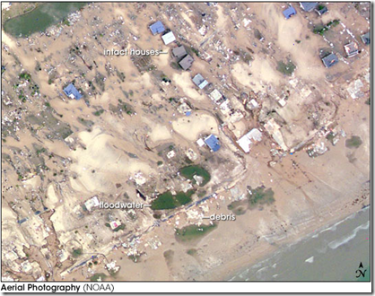
The following photo taken in Crystal Beach after Hurricane Ike in 2008 proves that staying home in the face of a flood, a hurricane, or other natural disaster can have deadly consequences.

image

If you live in an evacuation zone, you should obviously be prepared to leave immediately when ordered, but everyone should have a bug-out bag they can grab in the event they must quickly abandon their home (see  When Evacuation Is The Better Part Of Valor).


bob 001a

My Bug-out-bag, Canteen, & Toiletry kit


Another important aspect of preparedness for millions of families is anticipating the disaster needs of the non-human members of the family (see Prepping For Pets).


We don’t know where, or even if, a hurricane will make landfall this year. But last month we saw that NOAA predicts active 2013 Atlantic hurricane season.


If you haven’t already downloaded the updated Tropical Cyclone Preparedness Guide, now would be an excellent time to do so.


image


All this week we’ve focused on hurricane preparedness, but you’ll find dozens of other preparedness articles in the blog by searching this link.


And if you missed any of my earlier blogs this week on hurricane preparedness, you can visit them at the links below:


Grady Norton: The First Hurricane Forecaster

Hurricane Preparedness Week: Inland Flooding

Hurricane Preparedness Week & The Tale Of The Tape

Storm Surge Monday

National Hurricane Preparedness Week – Day 1