Showing posts with label Forecasting. Show all posts

Thursday, August 08, 2013

NOAA: Above Average Atlantic Hurricane Season Still Expected

image

The peak of the hurricane season is still ahead - Photo Credit NOAA


# 7553


Although the first two months of the 2013 Altantic Tropical season have been fairly uneventful (4 tropical storms, no hurricanes), there are still four months left to go, and NOAA continues to see conditions ripe for an above-average tropical season.


Earlier this month, we saw similar predictions from Colorado State University’s Dr. William Gray: August Hurricane Forecast Update.


Here is the latest prediction from NOAA.


NOAA: Atlantic hurricane season on track to be above-normal

August 8, 2013

 Image of Tropical Storm Dorian on July 24, 2013 from NOAA's GOES East satellite.

Image of Tropical Storm Dorian on July 24, 2013, from NOAA's GOES East satellite.

High resolution (Credit: NOAA)

NOAA issued its updated Atlantic hurricane season outlook today saying the season is shaping up to be above normal with the possibility that it could be very active. The season has already produced four named storms, with the peak of the season – mid-August through October – yet to come.

“Our confidence for an above-normal season is still high because the predicted atmospheric and oceanic conditions that are favorable for storm development have materialized,” said Gerry Bell, Ph.D., lead seasonal hurricane forecaster at NOAA’s Climate Prediction Center, a division of the National Weather Service. “Also, two of the four named storms to-date formed in the deep tropical Atlantic, which historically is an indicator of an active season.”


The conditions in place now are similar to those that have produced many active Atlantic hurricane seasons since 1995, and include above-average Atlantic sea surface temperatures and a stronger rainy season in West Africa, which produces wind patterns that help turn storm systems there into tropical storms and hurricanes.


The updated outlook calls for a 70 percent chance of an above-normal season. Across the Atlantic Basin for the entire season – June 1 to November 30 – NOAA’s updated seasonal outlook (which includes the activity to date of tropical storms Andrea, Barry, Chantal, and Dorian) projects a 70 percent chance for each of the following ranges:

  • 13 to 19 named storms (top winds of 39 mph or higher), including
    • 6 to 9 hurricanes (top winds of 74 mph or higher), of which
    • 3 to 5 could be major hurricanes (Category 3, 4 or 5; winds of at least 111 mph)

These ranges are above the 30-year seasonal averages of 12 named storms, six hurricanes and three major hurricanes.

(Continue . . . )


If you haven’t already downloaded the Tropical Cyclone Preparedness Guide, now would be an excellent time to do so. It is a short (12-page), easy to follow guide that will walk you through the basics of understanding (and surviving) hurricanes and tropical storms.

image


For more on hurricane preparedness you may wish to revisit:


Hurricane Preparedness Week: Day 6 & 7

Grady Norton: The First Hurricane Forecaster

Hurricane Preparedness Week: Inland Flooding

Hurricane Preparedness Week & The Tale Of The Tape

Storm Surge Monday

National Hurricane Preparedness Week – Day 1

Saturday, August 03, 2013

Dr. William Gray: August Hurricane Forecast Update

image

Photo Credit NOAA


# 7538


While the Atlantic has yet to produce a full fledged hurricane this year, we are only just now entering the peak of the tropical development season (see August Tropical Climatology).


With four months left in this year’s hurricane season (which ends Nov 30th) there there remains ample opportunity for the Atlantic to serve up some seriously dangerous weather.


Yesterday Professor William Gray and Phillip Klotzbach of Colorado University’s Department of Atmospheric Science released their August update for this year’s  hurricane Forecast, and they are continuing to call for an above average hurricane season.


FORECAST OF ATLANTIC SEASONAL HURRICANE ACTIVITY AND LANDFALL STRIKE PROBABILITY FOR 2013


We continue to anticipate an above-average season in 2013, although we have lowered our forecast slightly due to anomalous cooling in the eastern subtropical and tropical Atlantic. We expect an above-average probability of United States and Caribbean major
hurricane landfall.

  
(as of 2 August 2013)


By Philip J. Klotzbach1  and William M. Gray2

(Continue . . . )


The authors are forecasting 14 more named storms, 8 of which are forecast to reach hurricane force, and 3 `major hurricane’ status. 


While it isn’t possible to forecast where these storms may go, or what cities they may strike, the authors do provide `probabilities’ of a major hurricane strike on the U.S. coastline.


image


For more on landfall probabilities, you may wish to visit:


United States Landfalling Hurricane Probability Project


If you haven’t already downloaded the Tropical Cyclone Preparedness Guide, now would be an excellent time to do so. It is a short (12-page), easy to follow guide that will walk you through the basics of understanding (and surviving) hurricanes and tropical storms.

image


September is National Preparedness Month, but those who potentially live in the path of these storms (and that can be hundreds of miles inland) are urged every year to prepare in May, during National Hurricane Preparedness Week.

image

Some of my blogs on getting ready for this year’s tropical season include:


Hurricane Preparedness Week: Day 6 & 7

Grady Norton: The First Hurricane Forecaster

Hurricane Preparedness Week: Inland Flooding

Hurricane Preparedness Week & The Tale Of The Tape

Storm Surge Monday

National Hurricane Preparedness Week – Day 1

Thursday, May 30, 2013

Grady Norton: The First Hurricane Forecaster

image


Note: Today is day five of National Hurricane Preparedness Week, and the focus today is on forecasting.


A couple of years ago I took a look at the life of legendary hurricane forecaster Grady Norton, and at how hurricane forecasting technology has changed over the past 50 years.


Today, a (slightly updated) repeat of that column for those who missed it.


# 7340


For those of a certain age who can remember growing up along the Gulf or Atlantic coasts in the 1950’s - before the advent of weather satellites - the technology we have at hand today is truly remarkable.


Our satellites today can probe deep into storm clouds and detect wind speeds, water vapor, precipitation, and heat energy of storm systems a thousand miles from the nearest weather observation post.


image

Three different views from space, taken May 26th, 2011 1345Z – NOAA


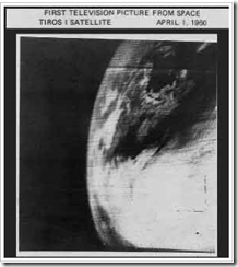
Weather forecasting began a new age when on April 1st 1960,  Tiros I - the world's first weather satellite - was launched into Earth orbit from Cape Canaveral, Florida.


For the first time, we had a `god's eye view' of earth. Regions of our globe where once cartographers could only inscribe "Here there be Dragons' could be watched 24 hours a day.


Our view of our world changed, practically overnight.


It was a wondrous day for everyone, except possibly for members of the Flat Earth Society. Below is the first television picture from earth orbit.


I was six years old, and I remember it like it was yesterday.


image


Sure the pictures were grainy, and the resolution laughable by today's standards, but for the first time we could watch from aloft and observe how and where hurricanes formed.


It meant we were no longer solely dependent on ship's reports and Hurricane Hunter aircraft to know if disaster lay just beyond the horizon.


It meant more than 12 hours warning to prepare for a storm.


TIROS 1 could take and transmit about 1 picture an hour, and only during daylight hours. Infrared capability – which allowed 24 hour coverage - was added to later `birds'.


Today, our reconnaissance satellites can take 40 pictures an hour, and see right through the clouds and measure rainfall, winds and even sea water temperatures. As a result, hurricane forecasting has improved tremendously over the past 50 years.


For those with an interest in how it was done before the advent of weather satellites and supercomputers, I’ve a bit of a treat today.


A profile of the first great hurricane forecaster – Grady Norton.


First, during the 1950’s there was a little remembered TV series called The Man Behind The Badge.  Hosted by Charles Bickford, the show profiled public servants who had made important contributions to public safety.


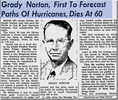
In 1955 a dramatized tribute to legendary hurricane forecaster Grady Norton was broadcast.  Grady had passed away suddenly of a stroke just a few months before while tracking Hurricane Hazel.


image


October 10th, 1954 Daytona News-Journal Article.


This 30 minute show stars Milburn Stone (of Gunsmoke Fame), and is hosted by a nostalgia TV site called LIKE Television.   It’s a fictionalized story, but I think you’ll find it well worth viewing.


Click the image below to view the show.

Iimage


Norton became the Chief Hurricane Forecaster at the Jacksonville Weather Bureau Hurricane center in 1935 and famously forecast the track of the 200+ MPH Labor Day storm that year, providing 12 critical hours of warning to the Keys and South Florida.


image


In 1943 the Hurricane forecasting office moved to Miami, as a joint effort of the National Weather Service, Air Force, and Navy.  Norton remained their Chief forecaster and most public spokesperson until his death in 1954.


It wasn’t until the mid-1960s that the NHC as we know it today was established as its own entity, separate from the National Weather Service.


While  the first director of the National Hurricane Center is listed as Gordon Dunn (1965–1967), Grady Norton is widely regarded as that agency’s first `unofficial’ director.


When meteorologists talk about Grady Norton today, they do so with considerable wonder and awe. His uncanny ability to track storms based on little more than ships reports was the stuff of legend.


While primitive by today’s standards, the work done by Grady Norton and other pioneers of meteorology during the first half of the last century deserves mention and remembrance.


Despite the limited technology of the day, they undoubtedly saved a lot of lives.


For a look at how forecasting is done today, you can watch the following short video from the National Hurricane Center.


Tomorrow, day six of hurricane preparedness week, we’ll be looking at planning for the storm’s arrival. If you haven’t already downloaded the updated Tropical Cyclone Preparedness Guide, now would be an excellent time to do so.

Tuesday, August 28, 2012

The Limits Of Intensity Forecasting

image  Source NHC


# 6521


The 8am EST advisory from the National Hurricane Center finds Isaac close to hurricane strength this morning as he slogs towards the northern Gulf coast at 7 miles per hour. Isaac will be pushing substantial storm surge (6-12 feet) towards the coast, along with high winds, rain, and the potential for tornadoes.  


Hurricane or not, Isaac remains a serious threat and is deserving of respect. 


Two days ago forecasters had already accurately predicted a Louisiana/Mississippi landfall - but they also expected Isaac to a strong CAT 2 storm by now. At least one model (HWRF) suggested a low CAT 3 intensity.


So what happened?


While forecast path prediction has come a long ways in the past 30 years, comparatively little progress has been made in intensity predictions.  


The number of atmospheric, oceanic, and land influences on budding tropical systems make it very difficult – with today’s technology – to accurately predict intensity changes 24 to 48 hours out.


We’ve often seen storms fail to reach their predicted potential, while others have rapidly intensified beyond any reasonable expectations.


Unexpectedly, Hurricane Charlie jumped from a CAT 2 storm to a CAT 4 storm in a matter of a couple of hours just before slamming into Southwest Florida in 2004.

image


This vexing subject was the topic of a presentation last year at the National Hurricane Conference.


image


It’s a fascinating 22-page document, but the upshot is, there’s not much hope that intensity forecasting is going to catch up with the recent gains in track forecasting anytime soon.


image


All of this uncertainty over storm intensity makes life very difficult for emergency managers.  They must decide – 48 hours in advance of a storm – whether to call for evacuations.


And the stakes are very high.


Evacuations are expensive, horribly inconvenient, and have the potential to claim more lives than the storm itself. During the evacuation of the Texas Gulf coast in advance of Hurricane Rita in 2005, more than 90 people died. 


And storms that failed to live up to their billing only serve to convince people not to evacuate the next time a storm threatens.


Be glad it isn’t your call.


In time, intensity forecasting will hopefully improve.  But tropical storms and hurricanes are complex and dynamic systems, and will probably always have the ability to throw us a curve.


All of which highlights the importance of individual, family, and community preparedness.  We must always be prepared for the unexpected.


National Preparedness Month is just a few days away, and the folks at FEMA, and READY.GOV would like to encourage you to learn how to make a planbuild a kit, and be informed.

image


And all next month I’ll be featuring preparedness articles in my blog.

Sunday, June 24, 2012

A Highly Uncertain Forecast

***UPDATED***


As I wrote this morning, the National Hurricane Center’s forecast track for T.S. Debby was apt to change, and as of the 5pm update, it most certainly has

image


The new forecast track (above) is still one of relatively `low confidence’, as the storm is moving slowly and steering currents could change. Basically, anyone along the Gulf Coast - from Texas to Florida - needs to keep an eye on this system.


image

11 am Forecast – Now outdated

# 6403


The 11 am discussion from the National Hurricane Center stresses just how difficult the current forecast for Tropical storm Debby is proving to be.  Model are not even close to consistent right now, with two very different scenarios a possibility.


First, here are the latest computer models, from the SWFTMD website. They basically have the storm going in every direction except south-south-west.  Which means that until these models coalesce, the entire gulf coast needs to keep an eye on this storm.


image


For now, based on the strength and past performance of some of these models, the NHC is going with a general movement to the west-north-west – putting the northern gulf coast as the likely target.


But as of 11 am today, Tropical Storm watches have been raised as far south as Pasco County on the west coast of Florida.  


image


The 11 am discussion has Debby reaching minimal hurricane strength over the next several days, but much of that will depend on its ultimate path.


As the forecasters warn below WE MUST BE READY TO MAKE A CHANGE OF THE FORECAST TRACK AT ANY TIME.


WTNT44 KNHC 241458

TCDAT4

TROPICAL STORM DEBBY DISCUSSION NUMBER   5
NWS NATIONAL HURRICANE CENTER MIAMI FL       AL042012
1000 AM CDT SUN JUN 24 2012

IT IS A VERY DIFFICULT AND HIGHLY UNCERTAIN FORECAST THIS MORNING. DEBBY HAS BEEN MOVING VERY SLOWLY TOWARD THE NORTHEAST...040 AT 3
KNOTS...WHILE THE WIND RADII HAVE BEEN EXPANDING IN THE EASTERN SEMICIRCLE.  THIS HAS PROMPTED ADDITIONAL TROPICAL STORM WARNINGSAND WATCHES FOR PORTIONS OF THE FLORIDA COAST.


DEBBY CONTINUES TO BE SHEARED WITH MOST OF THE THUNDERSTORM ACTIVITY NORTH AND EAST OF THE CENTER.  THIS SHEAR IS EXPECTED TO CONTINUE FOR THE NEXT DAY OR SO...ALTHOUGH SOME DECREASE IN THE SHEAR IS POSSIBLE AFTER THAT...PARTICULARLY IF THE ECMWF VERIFIES.  THE OFFICIAL FORECA ST IS A LITTLE LESS AGGRESSIVE THAN THE PREVIOUS FORECAST...BUT REMAINS ABOVE MOST OF THE EXPLICIT INTENSITY GUIDANCE.


THE TRACK FORECAST IS EVEN MORE COMPLEX. THE GFS INSISTS ON A TRACK TOWARD THE NORTHEAST AS DEBBY BECOMES EMBEDDED WITHIN A LARGE MID-LATITUDE TROUGH. HOWEVER...THE ECMWF AND THE HWRF BUILD A RIDGE TO THE NORTH OF DEBBY AND FORECAST A WESTWARD TRACK.  GIVEN THE WESTWARD TURN INHERITED FROM THE PREVIOUS FORECAST...AS WELL AS THE HISTORICAL STRONG RECORD OF THE ECMWF...THE NEW OFFICIAL FORECAST MOVES DEBBY INITIALLY A LITTLE BIT TO THE NORTHEAST TO REFLECT CURRENT TRENDS BUT THEN TURNS THE CYCLONE BACK TOWARD THE WEST OR WEST-NORTHWEST IN 24 TO 36 HOURS.  A MAJORITY OF THE GFS ENSEMBLE MEMBERS NOW ARE CONSISTENT WITH THE DETERMINISTIC RUN...WHICH WAS NOT THE CASE YESTERDAY... MAKING A STRONGER CASE FOR THE EASTWARD SOLUTION.  WE MUST BE READY TO MAKE A CHANGE OF THE FORECAST TRACK AT ANY TIME.


FORECAST POSITIONS AND MAX WINDS


INIT  24/1500Z 28.0N  86.2W   50 KT  60 MPH
12H  25/0000Z 28.5N  85.8W   50 KT  60 MPH
24H  25/1200Z 28.5N  85.8W   50 KT  60 MPH
36H  26/0000Z 28.5N  86.2W   55 KT  65 MPH
48H  26/1200Z 28.7N  87.0W   60 KT  70 MPH
72H  27/1200Z 29.0N  88.4W   65 KT  75 MPH
96H  28/1200Z 29.5N  90.5W   45 KT  50 MPH
120H  29/1200Z 30.0N  91.5W   30 KT  35 MPH


And a reminder, the National Hurricane Center (NHC) has two Twitter accounts, one for the Atlantic basin (which includes the Gulf of Mexico and the Caribbean Sea):

Follow NHC_Atlantic on Twitter U.S. National Hurricane Center (Atlantic) - @NHC_Atlantic

and one for the Eastern North Pacific basin:

Follow NHC_Pacific on Twitter U.S. National Hurricane Center (Eastern Pacific) - @NHC_Pacific

In addition to the Twitter notifications, NHC also provides product notifications by email. Please visit hurricanes.gov/signup.shtml to sign up for this service.

And if you aren’t already following

on twitter, you might want to add them to your list.

And finally, if you haven’t already downloaded the Tropical Cyclone Preparedness Guide, now would be an excellent time to do so.  It is a short (12-page), easy to follow guide that will walk you through the basics of understanding (and surviving) hurricanes and tropical storms.

image

Thursday, May 24, 2012

NOAA: `Near Normal’ Hurricane Season Predicted


# 6344


In late May, just before the start of the Atlantic Hurricane season, we get a number extended outlooks that attempt to predict the amount of tropical activity we might expect to see over the next six months. 


Earlier this year Professor William Gray and Phillip Klotzbach of Colorado University’s Department of Atmospheric Science released their updated 2012 Extended-Range Hurricane Forecast for the Atlantic Tropical basin, where they called for a below-average hurricane season (see It Only Takes One).


Gray and Klotzbach will provide an updated outlook again in early June.


Today, NOAA has released their extended outlook, and after several very active years, they are calling for a 70% chance of seeing a `normal’ hurricane season.  


Here are some excerpts from today’s story.


NOAA predicts a near-normal 2012 Atlantic hurricane season

Anniversary of Hurricane Andrew underscores necessity to prepare every year

image

May 24, 2012

Conditions in the atmosphere and the ocean favor a near-normal hurricane season in the Atlantic Basin this season, NOAA announced today from Miami at its Atlantic Oceanographic and Meteorological Laboratory, and home to the Hurricane Research Division.


For the entire six-month season, which begins June 1, NOAA’s Climate Prediction Center says there’s a 70 percent chance of nine to 15 named storms (with top winds of 39 mph or higher), of which four to eight will strengthen to a hurricane (with top winds of 74 mph or higher) and of those one to three will become major hurricanes (with top winds of 111 mph or higher, ranking Category 3, 4 or 5). Based on the period 1981-2010, an average season produces 12 named storms with six hurricanes, including three major hurricanes.


“NOAA’s outlook predicts a less active season compared to recent years,” said NOAA Administrator Jane Lubchenco, Ph.D. “But regardless of the outlook, it’s vital for anyone living or vacationing in hurricane-prone locations to be prepared. We have a stark reminder this year with the 20th anniversary of Hurricane Andrew.” Andrew, the Category 5 hurricane that devastated South Florida on August 24, 1992, was the first storm in a late-starting season that produced only six named storms.


Favoring storm development in 2012: the continuation of the overall conditions associated with the Atlantic high-activity era that began in 1995, in addition to near-average sea surface temperatures across much of the tropical Atlantic Ocean and Caribbean Sea, known as the Main Development Region. Two factors now in place that can limit storm development, if they persist, are: strong wind shear, which is hostile to hurricane formation in the Main Development Region, and cooler sea surface temperatures in the far eastern Atlantic.


“Another potentially competing climate factor would be El Niño if it develops by late summer to early fall. In that case, conditions could be less conducive for hurricane formation and intensification during the peak months (August-October) of the season, possibly shifting the activity toward the lower end of the predicted range,” said Gerry Bell, Ph.D., lead seasonal hurricane forecaster at NOAA’s Climate Prediction Center.

(Continue . . . )


Next week will kick off Hurricane Preparedness Week, and again this year I’ll have a number of blogs on the subject.


image


And just as a reminder:


The NHC has two Twitter accounts, one for the Atlantic basin (which includes the Gulf of Mexico and the Caribbean Sea):


Follow NHC_Atlantic on Twitter U.S. National Hurricane Center (Atlantic) - @NHC_Atlantic


and one for the Eastern North Pacific basin:
Follow NHC_Pacific on Twitter U.S. National Hurricane Center (Eastern Pacific) - @NHC_Pacific


In addition to the Twitter notifications, NHC also provides product notifications by email. Please visit hurricanes.gov/signup.shtml to sign up for this service.

And if you aren’t already following

on twitter, you might want to add them to your list.

Thursday, April 05, 2012

It Only Takes One


# 6263


Yesterday (Apr. 4th) Professor William Gray and Phillip Klotzbach of Colorado University’s Department of Atmospheric Science released their updated 2012 Extended-Range Hurricane Forecast for the Atlantic Tropical basin.


And while these yearly forecasts are not always on target - as a resident of the Gulf Coast of Florida – I’m admittedly a little relieved to see that this year they are calling for a below-average hurricane season.


But one need only remember that 1992, a year when Dr. Gray and his team predicted (quite correctly) a lower-than-average hurricane season, was the year that Category Five Hurricane Andrew slammed into south Florida, inflicting horrific damage to Homestead and surrounding areas.


image


It may sound like a cliché, but it is absolutely true.

It only takes one. . . .


The past couple of years have seen an above-average number of Atlantic tropical storms, yet most of these intense storms remained out to sea, sparing the coastlines of the United States.


Yesterday’s forecast (see below) will be updated again in early June, but for now these researchers are predicting:


EXTENDED RANGE FORECAST OF ATLANTIC SEASONAL HURRICANE ACTIVITY AND LANDFALL STRIKE PROBABILITY FOR 2012


We anticipate that the 2012 Atlantic basin hurricane season will have reduced activity compared with the 1981-2010 climatology. The tropical Atlantic has anomalously cooled over the past several months, and it appears that the chances of an El Niño event this summer and fall are relatively high. 

We anticipate a below-average probability for major hurricanes making landfall along the United States coastline and in the Caribbean. However, coastal residents are reminded that it only takes one hurricane making landfall to make it an active season for them, and they need to prepare the same for every season, regardless of how much activity is predicted.


(as of 4 April 2012)


By Philip J. Klotzbach  and William M. Gray


image


The full 42-page PDF file, giving their rationale, and more detailed forecasts can be downloaded here.


Their analysis of the impact that global warming may (or may not) be having on the Atlantic’s hurricane activity is also quite interesting. 


As you can see from the map below, between 1920-1965 – at a time when the earth was going through a general cooling trend – the number of major hurricanes impacting the eastern United states was three times greater than during the last 46 (warmer) years.


image


The authors write:


We have no plausible physical reasons for believing that Atlantic hurricane frequency or intensity will change significantly if global ocean temperatures were to continue to rise.

For instance, in the quarter-century period from 1945-1969 when the globe was undergoing a weak cooling trend, the Atlantic basin experienced 80 major (Cat 3-4-5) hurricanes and 201 major hurricane days.

By contrast, in a similar 25-year period from 1970-1994 when the globe was undergoing a general warming trend, there were only 38 Atlantic major hurricanes (48% as many) and 63 major hurricane days (31% as many) (Figure 21).  Atlantic SSTs and hurricane activity do not follow global mean temperature trends.


For more on landfall probabilities, you may wish to visit:


United States Landfalling Hurricane Probability Project


While we will hopefully see a less active hurricane season, there are no guarantees. Now is a good time to begin to prepare for the upcoming season.

Hurricane preparedness week is in May, and NOAA has a full slate of videos available on their website to help you understand the risks, and to prepared.


image

    Saturday, August 27, 2011

    Of Hurricanes, Pandemics, And Intensity Forecasting


    image

    Irene looking a little ragged this morning


    # 5789


    For hurricanes, life is short and environmental threats to their existence are many. 


    It takes the right balance of environmental factors; low wind shear, warm waters to traverse and feed from, little or no interaction with land masses, and abundant moist tropical air to keep them going full tilt.


    Take away, or reduce any of these vital  components, and even powerful storms can quickly lose strength or fall apart altogether. 


    Irene, which was forecast to be a major (Cat 3) hurricane at landfall only 24 hours ago, has instead weakened overnight into a strong CAT 1 storm, with sustained winds of 90 MPH and higher gusts.


    Of course, even at CAT 1 strength, Irene is not something to trifle with. She is still capable of producing a serious amount of damage, particularly from storm surge, so those in her path should not let their guard down.


    But her impact is likely to be less than originally feared.


    From the 5am NHC discussion:


    LAND INTERACTION...DRY AIR ENTRAINMENT...AND INCREASING VERTICALWIND SHEAR SHOULD CAUSE IRENE TO WEAKEN AS IT MOVES ALONG THE U.S. EAST  COAST. HOWEVER...THE CYCLONE IS EXPECTED TO REMAIN A HURRICANE WITH A VERY LARGE WIND FIELD UNTIL AFTER LANDFALL IN NEW ENGLAND.  EXTRATROPICAL TRANSITION SHOULD OCCUR AFTER THE NEW ENGLAND LANDFALL...WITH IRENE GRADUALLY WEAKENING FROM 48-120 HR.


    As I’ve mentioned in the past, the  National Hurricane Center’s confidence in their intensity forecasting is less than in their forecast tracks.


    The science is improving, but the number of constantly changing variables involved is absolutely staggering, and so storm intensity remains difficult to predict.


    The conditions supporting a stronger Irene appeared to be in place.


    She was far enough from land as to suffer little interference, the waters she was passing over were still relatively warm, and wind shear – although beginning to increase - had been low for the past several days.


    But it appears that Irene has been weakened by the entrainment of drier air, pulled into the storm from the west. 


    While there may be some who will claim the NHC overstated the dangers, and in doing so disrupted the lives of millions of people this weekend, the truth is this storm could easily have gone the other way, and become stronger.


    And when it is your job to provide 48 hours warning of what could be a major threat, you can’t weasel-word your warnings just to give yourself a convenient `out’.


    The conditions were there to keep Irene a major storm at landfall, and so with lives at stake, the only prudent thing was to assume that could happen.


    A situation not so dissimilar to what public health officials faced a little over 2 years ago when a novel influenza virus emerged, and began spreading rapidly around the globe.


    Despite many unknowns, the conditions were in place to support the declaration of a pandemic. Even though the World Health Organization stated the severity was impossible to predict, they were forced to assume the worst, and plan accordingly.


    As with the NHC warnings on Irene, it was the right thing to do.


    The fact that the pandemic proved less severe than first thought was pure luck. The next time, we may not be so fortunate.


    Sadly, many people who ride through Irene this weekend may decide that hurricanes aren’t so bad after all. They will think they’ve gone through a major storm, when they really haven’t, and may fail to listen to officials and take prudent steps the next time a storm threatens.


    Just like the millions of people who now believe that another flu pandemic isn’t anything to worry about, since the last one was so mild.


    Since past performance is no guarantee of future results, either assumption could prove disastrous down the road.


    The bottom line:  Even if we are lucky enough to dodge a bullet today . . . 


    We shouldn’t assume ourselves to be bulletproof tomorrow.