Showing posts with label Risks. Show all posts

Monday, August 11, 2014

Ebola: Parsing The CDC’s Low Risk vs High Risk Exposures

image


# 8940


Five days ago (Aug 7th)  the CDC released a revised Case Definition for Ebola Virus Disease (EVD) which I covered here. As has been pointed out before, case definitions and other guidance documents are based on the CDC’s current understanding of a particular pathogen  – but they not static – and they can be expected to evolve as more is learned about any given threat.


In this latest guidance, the CDC set forth three categories of potential exposure; High Risk, Low Risk, and No Known Exposures.


The High Risk exposures are the ones we have all heard about time and again:


High risk exposures

A high risk exposure includes any of the following:

  • Percutaneous, e.g. the needle stick, or mucous membrane exposure to body fluids of EVD patient
  • Direct care or exposure to body fluids of an EVD patient without appropriate personal protective equipment (PPE)
  • Laboratory worker processing body fluids of confirmed EVD patients without appropriate PPE or standard biosafety precautions
  • Participation in funeral rites which include direct exposure to human remains in the geographic area where outbreak is occurring without appropriate PPE


                  The CDC also listed Low Risk exposures, and over the past day or so have caused quite a stir on the Internet, with charges that this is some kind of `admission’  that Ebola is an airborne virus.


                  It isn’t, but that hardly matters if your primary goal is to drive web traffic.


                  First, let’s look what the CDC considers to be Low Risk exposure:


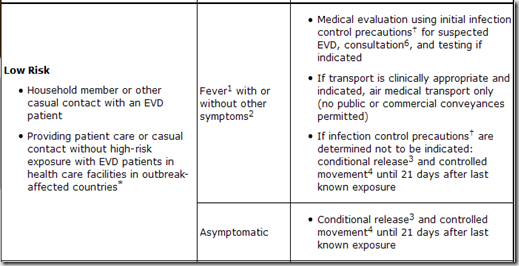
                  A low risk exposure includes any of the following

                  • Household member or other casual contact1 with an EVD patient
                  • Providing patient care or casual contact1 without high-risk exposure with EVD patients in health care facilities in EVD outbreak affected countries*


                  The term `casual contact’ is defined as:


                  a) being within approximately 3 feet (1 meter) or within the room or care area for a prolonged period of time (e.g., healthcare personnel, household members) while not wearing recommended personal protective equipment (i.e., droplet and contact precautions–see Infection Prevention and Control Recommendations); or

                  b) having direct brief contact (e.g., shaking hands) with an EVD case while not wearing recommended personal protective equipment (i.e., droplet and contact precautions–see Infection Prevention and Control Recommendations).

                  At this time, brief interactions, such as walking by a person or moving through a hospital, do not constitute casual contact.


                  For the record, airborne viruses transmit well beyond a 1 meter radius of a patient. This 1 meter zone is basically within  `spittle range’, where large droplets of mucus, blood, sweat, or other bodily fluids could potentially be coughed, sneezed, or otherwise propelled or flung onto another person.


                  While these risks may be considered low, they are not zero, and so it is important that people understand them.  Still, to be infectious, a person has to be both infected, and symptomatic.  And the odds of being exposed to someone outside of the `hot zones’ in West Africa right now are very slim.


                  There is actually another type of transmission, not really addressed here, and that is through fomites - surfaces or objects that an infected person might contaminate with body fluids - that could later infect someone else.


                  The trouble with including fomite exposure as an exposure risk is - unless you knew you’d been in a room with an Ebola patient (already covered above under Low risk) - you’d have no reason to suspect you’d touched a contaminated surface.


                  While I took exception to what I considered to be an overly simplistic infographic last week on Ebola transmission risks (see The Ebola Sound Bite & The Fury), I consider these guidelines – based on what we currently know about the Ebola virus – to be quite reasonable.


                  As far as what should be done about people who fall into either High Risk or Low Risk Exposure groups, the CDC has released the following tables in a document called Interim Guidance for Monitoring and Movement of Persons with Ebola Virus Disease Exposure.

                  image


                  image

                  image

                  * Outbreak-affected countries include Guinea, Liberia, Nigeria and Sierra Leone as of August 4, 2014

                  1 Fever: measured temperature ≥ 38.6°C/ 101.5°F or subjective history of fever

                  2 Other symptoms: includes headache, joint and muscle aches, abdominal pain, weakness, diarrhea, vomiting, stomach pain, lack of appetite, rash, red eyes, hiccups, cough, chest pain, difficulty breathing, difficulty swallowing, bleeding inside and outside of the body. Laboratory abnormalities include thrombocytopenia (≤150,000 /µL) and elevated transaminases.

                  3 Conditional release: Monitoring by public health authority; twice-daily self-monitoring for fever; notify public health authority if fever or other symptoms develop

                  4 Controlled movement: Notification of public health authority; no travel by commercial conveyances (airplane, ship, and train), local travel for asymptomatic individuals (e.g. taxi, bus) should be assessed in consultation with local public health authorities; timely access to appropriate medical care if symptoms develop

                  5 Self-monitor: Check temperature and monitor for other symptoms

                  6 Consultation: Evaluation of patient's travel history, symptoms, and clinical signs in conjunction with public health authority

                  Friday, July 18, 2014

                  USGS: Updated U.S. Seismic Risk Hazard Maps

                  image


                  # 8846


                  Yesterday the USGS released a 243 page PDF report outlining the revised seismic hazard risks for the United States – their first major update since 2008 – and among its findings it reports a higher risk of strong quakes in the Eastern United States than previously appreciated. 


                  Be warned, with hundreds of maps and graphics, this is a very large (113mb) download.


                  image


                  Documentation for the 2014 Update of the United States National Seismic Hazard Maps

                  By Mark D. Petersen, Morgan P. Moschetti, Peter M. Powers, Charles S. Mueller, Kathleen M. Haller, Arthur D. Frankel, Yuehua Zeng, Sanaz Rezaeian, Stephen C. Harmsen, Oliver S. Boyd, Ned Field, Rui Chen, Kenneth S. Rukstales, Nico Luco, Russell L. Wheeler, Robert A. Williams, and Anna H. Olsen
                  Abstract

                  The national seismic hazard maps for the conterminous United States have been updated to account for new methods, models, and data that have been obtained since the 2008 maps were released (Petersen and others, 2008). The input models are improved from those implemented in 2008 by using new ground motion models that have incorporated about twice as many earthquake strong ground shaking data and by incorporating many additional scientific studies that indicate broader ranges of earthquake source and ground motion models. These time-independent maps are shown for 2-percent and 10-percent probability of exceedance in 50 years for peak horizontal ground acceleration as well as 5-hertz and 1-hertz spectral accelerations with 5-percent damping on a uniform firm rock site condition (760 meters per second shear wave velocity in the upper 30 m, VS30). In this report, the 2014 updated maps are compared with the 2008 version of the maps and indicate changes of plus or minus 20 percent over wide areas, with larger changes locally, caused by the modifications to the seismic source and ground motion inputs.


                  Although earthquakes in the Eastern half of the United States have been recorded in the past (including the Charleston, SC earthquake of 1886), the August 2011 5.8 earthquake that rocked Virginia and the Nation’s capital (see USGS Statement On The Virginia Earthquake) provided fresh evidence not only of their potential to occur,  but also how widely felt they may be (see USGS: Eastern Earthquakes - Rare But Powerful).


                  Another strong quake a few months later in the Heartland (see 5.6 Mag Quake Rattles Oklahoma), has been followed by hundreds of additional quakes in a region not expected to produce that much seismic activity. 


                  Additional earthquake research has turned up new fault lines in California, and perhaps most worrisome of all, found the potential for a much larger quake from the Cascadia Fault in the Pacific Northwest than previously estimated (see Just A Matter Of Time for more on this threat)


                  While all 50 states have at least some seismic potential (yes, even Florida), 42 states are viewed as having a reasonable chance of seeing a damaging quake in the next 50 years, and 16 states in particular are considered at highest risk.  The USGS press release states:


                  The hazard is especially high along the west coast, intermountain west, and in several active regions of the central and eastern U.S., such as near New Madrid, MO, and near Charleston, SC. The 16 states at highest risk are Alaska, Arkansas, California, Hawaii, Idaho, Illinois, Kentucky, Missouri, Montana, Nevada, Oregon, South Carolina, Tennessee, Utah, Washington, and Wyoming.


                  While they acknowledge the risks of man-made earthquakes – due primarily to fracking and injection wells – research into these hazards is just getting started.  The USGS states:


                  Induced Earthquakes … Research Underway

                  Some states have experienced increased seismicity in the past few years that may be associated with human activities such as the disposal of wastewater in deep wells.

                  One specific focus for the future is including an additional layer to these earthquake hazard maps to account for recent potentially triggered earthquakes that occur near some wastewater disposal wells. Injection-induced earthquakes are challenging to incorporate into hazard models because they may not behave like natural earthquakes and their rates change based on man-made activities.


                  While it may not be predictive of future events, so far 2014 has provided a major uptick in seismic activity in the United States, and around the globe.  Southern California, Alaska, and California have all reported increased activity (see LA Times Quakes are increasing, but scientists aren't sure what it means).


                  Last December, in Dr. Lucy Jones: `Imagine America Without Los Angeles’, we looked at a presentation given by Dr. Jones at the  annual meeting of the American Geophysical Union (held this year in San Francisco),  that emphasized that should the `big one’ hit Southern California, we could literally `lose’ Los Angeles.


                  She warned that the damage could be far greater, and last much longer, than most people believe.  While 99 out of 100 modern buildings might remain standing, the (often buried) infrastructure needed to provide water, electricity, internet connectivity, and natural gas – the lifeblood -  to the region could be devastated (see CBS News report).


                  If this sounds like hyperbole, in 2010 (see Revised Risk Of `The Big One’ Along San Andreas Fault) we looked at a study that suggested that Southern California may be more overdue for another major quake than previously thought, and in the following year (see Estimating The Economic Impact Of A San Andreas Quake) we looked at a report from the U.S. Bureau of Labor Statistics that endeavored to gauge the crippling impact that a highly feasible (and long overdue) 7.8 magnitude Southern California earthquake would have on jobs and local businesses.

                  image

                  Download PDF file

                  A quake of this magnitude, they estimate, could affect  430,000 businesses and 4.5 million workers and deliver a devastating – and prolonged – blow to the local (and national) economy.


                  While attempts at predicting earthquakes have met with little success, we do know that over time, seismically active regions will be hit again and again, and that the only defense is to be prepared for when that happens.


                  Seismic threats extend beyond earthquakes, as they encompass volcanic eruptions (see Washington State: Volcano Awareness Month) - and Tsunamis – both of which have the ability to affect both people and property thousands of miles away from the originating event  (see The USGS West Coast Tsunami Scenario Report & East Coast Tsunami Threats).


                  Which is why everyone should have a disaster plan, not just those who live in an earthquake zone.


                  As a bare minimum, everyone should have a well thought out disaster and family communications plan, along with a good first aid kit, a `bug-out bag’, and sufficient emergency supplies to last at least 72 hours.


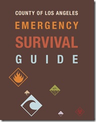
                  In When 72 Hours Isn’t Enough, I highlighted  a colorful, easy-to-follow, 100 page `survival guide’ released by Los Angeles County, that covers everything from earthquake and tsunami preparedness, to getting ready for a pandemic.

                  image

                  The guide may be downloaded here (6.5 Mbyte PDF).

                  While designed specifically for the nearly 10 million residents of Los Angeles County, this guide would be a valuable asset for anyone interested in preparing for a variety of hazards. And in Los Angeles, the advice is to have emergency supplies (food, water, etc) to last up to 10 days. In my humble opinion, 2-weeks in an earthquake zone isn’t overkill.


                  Working to improve earthquake awareness, preparation, and safety is Shakeout.org, which promotes yearly earthquake drills and education around the country (see NPM13: A Whole Lotta Shakeouts Going On).  If you live in one of these seismically active areas, I would encourage you to take part in these yearly drills.

                  image

                  To become better prepared as an individual, family, business owner, or community to deal with all types of disasters, I would invite you to visit the following preparedness sites.


                  FEMA http://www.fema.gov/index.shtm

                  READY.GOV http://www.ready.gov/

                  AMERICAN RED CROSS http://www.redcross.org/


                  And lastly, in NPM13: The Greatest Prep Of All,  I wrote about what I consider to be the most important preparedness step you can take – having, and being,  a disaster buddy.  Cultivating a network of family and friends to whom you can turn for help in a disaster, to who can turn to you for aid,  if they need it.


                  Because no matter where you live, its just a matter of time before the next disaster strikes.

                  Friday, January 31, 2014

                  CDC Director Frieden: On Preventing A Pandemic

                  image

                  Photo Credit WHO


                  # 8253


                  Yesterday the CDC’s director Dr. Thomas Frieden held a telebriefing called  U.S. safer when CDC works with other countries to fight infectious diseases, to `discuss improvements in disease detection and response that may serve as a model for fighting infectious disease throughout the world’.


                  The transcript and audio are now available online, for those who were unable to attend.


                  Central to his presentation were two reports that appeared yesterday in the MMWR.


                  Rapidly Building Global Health Security Capacity — Uganda Demonstration Project, 2013

                  Strengthening Global Health Security Capacity — Vietnam Demonstration Project, 2013


                  Today, in a follow up, Dr. Frieden has penned a special blog post for CNN, where he discusses the dangers of a pandemic, and the steps that need to be put in place to prevent or mitigate its arrival.


                  08:49 AM ET

                  How to prevent the next pandemic

                  By Tom Frieden, Special to CNN

                  Editor’s note: Dr. Tom Frieden is the director for the Center for Disease Control. The views expressed are his own.

                  Today marks the Lunar New Year – and the world’s largest annual migration. There will be more than 3.6 billion transit trips within China, in addition to countless international trips. Yet this celebration comes at a time of growing concern about the H7N9 avian influenza virus. And this concern is not unfounded – should this virus change into a form that easily spreads between people, the world’s next pandemic could occur in the next three weeks.

                  This combination of mass travel and an emerging virus such as this should underscore the connectedness of health security between countries. Of course, H7N9 influenza is just one example of how the health security of all nations, including the United States, depends on the health security of each individual nation. And regardless of where outbreaks occur, stopping them at the source is the most effective and cheapest way to save lives at home and abroad.

                  (Continue . . . )

                  Sunday, January 26, 2014

                  USGS: 6.0 Earthquake Strikes Greece

                  image

                  Credit USGS 


                  # 8223


                  A strong, relatively shallow earthquake and a moderate aftershock have struck the Southern coastline of Greece, and preliminary reports indicate there has been some local damage and possible injuries.  The towns closest to the epicenter are generally small (3K-5K pop.), and so the damage may not be as great as it might have been in a more populated area.


                  image

                  image


                  When it comes to earthquakes we usually think first of the Pacific’s Ring Of Fire, but Europe has a long history of destructive quakes as well.


                  In 2011,  in A Look At Europe’s Seismic Risks, we took look at some of the devastating earthquakes to strike Europe over the past 700 years, including the quake that leveled the Swiss town of Basel in 1356 and the horrific earthquake and tsunami that struck Portugal in 1755 on November 1st (All Saint’s Day).


                  In December of 2011, in WHO e-Atlas Of Natural Disaster Risks To Europe, we looked at some of the seismic risks to Europe. Also in 2011 (see UNDP: Supercities At Seismic Risk) we saw a report that stated that half of the world’s supercities (urban areas with 2 million – 15 million inhabitants) are at high risk for seismic activity.


                  And more recently, in January of this 2012 (see UN Agency Warns On Global Seismic Risks), the United Nations International Strategy For Disaster Reduction (UNIDSR.Org) issued a cautionary warning about ignoring seismic threats.


                  While we can’t predict where the next earthquake will strike, or do anything to stop it, we can prepare to deal with one when it happens.


                  For good, solid information on how prepare for `the big one’ (even if you live someplace other than Los Angeles), I would recommend you download, read, and implement the advice provided by the The L. A. County Emergency Survival Guide.

                  image

                  While US-centric, FEMA  has an earthquake hazard webpage with a lot of resources that would be of use to just about anyone, including the following preparedness information.


                  Emergencies happen every day.  Disasters, admittedly, less often. But in either event, preparedness is key.

                  Monday, October 14, 2013

                  California Quakes : Concrete Concerns

                  image

                  SCEC Interactive Map – Significant Southern California Quakes


                  #7855


                  Yesterday the Los Angeles Times ran an extensive report on an in-house analysis of a number of large, and extremely vulnerable-during-an-earthquake, concrete buildings in that city.  The authors (Rong-Gong Lin II, Rosanna Xia and Doug Smith) state that the city has been aware of the dangers for decades, but has refused to require building owners to retrofit their properties for earthquake safety, despite the fact that the area is believed `overdue’ for a major earthquake.


                  It’s an informative report on seismic risks, earthquake resistant building techniques, and local politics. Well worth reading.


                  CONCRETE RISKS

                  The city has rejected calls to make a list of concrete buildings at risk of collapsing in a major quake, but a Times analysis finds there could be more than 1,000 — many of them homes and offices.
                  By Rong-Gong Lin II, Rosanna Xia and Doug Smith

                  October 13, 2013

                  More than 1,000 old concrete buildings in Los Angeles and hundreds more throughout the county may be at risk of collapsing in a major earthquake, according to a Times analysis.

                  By the most conservative estimate, as many as 50 of these buildings in the city alone would be destroyed, exposing thousands to injury or death.

                  (Continue . . . )


                  While admittedly a local story, Los Angeles isn’t the only major U.S. city with concrete buildings that lies in an active seismic zone; Memphis, St. Louis, Charleston, Seattle, Portland, San Francisco, Salt Lake City  . . . even New York City, all have varying degrees of seismic risks.  


                  image

                  Seismic Hazard Map – Credit USGS


                  But the West Coast, probably more than any other region of the United States, is viewed as being at particular risk.


                  In 2010 (see Revised Risk Of `The Big One’ Along San Andreas Fault) we looked at a study that suggested that Southern California may be more overdue for another major quake than previously thought, and in the following year (see Estimating The Economic Impact Of A San Andreas Quake) we looked at a report from the U.S. Bureau of Labor Statistics that endeavored to gauge the crippling impact that a highly feasible (and long overdue) 7.8 magnitude Southern California earthquake would have on jobs and local businesses.

                  image

                  Download PDF file

                  A quake of this magnitude, they estimate, could affect  430,000 businesses and 4.5 million workers and deliver a devastating – and prolonged – blow to the local (and national) economy.


                  For a comprehensive guide on how you can prepare for `the big one’ (even if you live someplace other than Los Angeles), I would recommend you download, read, and implement the advice provided by the The L. A. County Emergency Survival Guide.

                  image


                  Large earthquakes can also generate massive tsunamis, which can travel thousands of miles in a matter of a few hours.  We’ve looked at the United State’s tsunami risks recently, in NPM13: The USGS West Coast Tsunami Scenario Report & East Coast Tsunami Threats.


                  It isn’t enough to have a kit, and a plan during an earthquake. You need to know what to do to protect life and limb while the shaking is going on.  And for that, we have the ever-growing Great Shakeout Drill (see  NPM13: A Whole Lotta Shakeouts Going On).


                  image


                  Later this week (Thurs, Oct 17 at 10:17am) , California, along with many other states, territories, and countries will hold their annual Great Shakeout Drill.  Millions of residents, from the United States and Canada, to New Zealand, Italy, and Japan, will take part in this yearly Drop, Cover, & Hold On drill. A video, demonstrating the technique is available on the California Shakeout Youtube Channel.

                  image


                  For more information on emergency preparedness, I would invite you  to visit:


                  FEMA http://www.fema.gov/index.shtm

                  READY.GOV http://www.ready.gov/

                  AMERICAN RED CROSS http://www.redcross.org/


                  And for some earlier blogs on the seismic hazards in the United States, and around the world, you may wish to revisit:

                  Just A Matter Of Time

                  Academics Debate Odds Of Tokyo Earthquake

                  UN Agency Warns On Global Seismic Risks


                  Tuesday, January 08, 2013

                  Global Risks Report: 2013

                  image


                  # 6832


                  The World Economic Forum is a Geneva based non-profit foundation, originally called the `European Management Forum’ when it was created in 1971 by a business professor at the University of Geneva. In 1987, the foundation was renamed as they expanded their scope beyond Europe, to include broader global issues.


                  Late each January, the WEF invites more than two thousand select business, political and NGO leaders, academics, intellectuals, and members of the media to meet for 5 days in Davos, Switzerland to discuss the most pressing issues facing the world, and each January we get a new Global Risks Report.


                  The 2013 Global Risks Report is more ambitious, and more accessible, than ever before, with an interactive website, videos, along with the detailed report.


                  I’ve only just started to examine this data-heavy report, but wanted to provide the links, and some highlights, to my readers. 


                  First some excerpts from the press release:


                  World More at Risk from Markets and Mother Nature – Global Risks 2013 report

                  Rim El Habibi, Media Associate, Tel.: +41 (0) 79 531 3111, rim.elhabibi@weforum.org

                  • Persistent economic malaise coupled with frequent extreme weather events an increasingly dangerous mix
                  • National resilience is crucial to tackle unpredictable global threats; new country rating system launched
                  • Health and hubris, digital wildfires and environmental/economic stress are the three risk cases for 2013
                  • The report analyses 50 global risks, with breakdowns for China, Middle East/North Africa and Latin America
                  • Read the Global Risks 2013 report in full at http://www.weforum.org/globalrisks2013

                  London, United Kingdom, 8 January 2013 – The world is more at risk as persistent economic weakness saps our ability to tackle environmental challenges, according to the World Economic Forum’s Global Risks 2013 report.


                  The report highlights wealth gaps (severe income disparity) followed by unsustainable government debt (chronic fiscal imbalances) as the top two most prevalent risks, in a survey of over 1,000 experts and industry leaders, which reflects a slightly more pessimistic outlook overall for the coming 10 years.


                  Following a year scarred by extreme weather, from Hurricane Sandy to flooding in China, respondents rated rising greenhouse gas emissions as the third most likely global risk overall, while the failure of climate change adaptation is seen as the environmental risk with the most knock-on effects for the next decade.


                  “These global risks are essentially a health warning regarding our most critical systems,” warned Lee Howell, the editor of the report and Managing Director at the World Economic Forum. “National resilience to global risks needs to be a priority so that critical systems continue to function despite a major disturbance,” he added.


                  Axel P. Lehmann, Chief Risk Officer at Zurich Insurance Group, said: “With the growing cost of events like Superstorm Sandy, huge threats to island nations and coastal communities, and no resolution to greenhouse gas emissions, the writing is on the wall. It is time to act.”

                  Global Risks 2013 analyses three major risk cases of concern globally:

                  1. Health and Hubris

                  2. Economy and Environment under Stress

                  3. Digital Wildfires


                  (Continue . . .)

                  Beyond the serious economic and environmental concerns expressed in the 2013 edition, the authors also focus on global health, and the risks of complacency in Health and Hubris.  Again from the press release:

                  Huge strides forward in health have left the world dangerously complacent. Rising resistance to antibiotics could push overburdened health systems to the brink, while a hyperconnected world allows pandemics to spread. This risk case draws on the connections between antibiotic resistance, chronic disease and the failure of the international intellectual property regime, recommending more international collaboration and different funding models.


                  While it is impossible to accurately predict future crises, or their timing, the authors - in collaboration with the science Journal Nature – also consider a set of five X factors that may be on the horizon, including:


                  • Runaway Climate Change

                  • Significant Cognitive Enhancement

                  • Rogue Deployment of Geoengineering

                  • Costs of Living Longer

                  • Discovery of Alien Life


                  The annual meeting at Davos, and the release of the WEF Global Risks report, is not without controversy.


                  There are many who perceive the World Economic Forum to be secretive, elitist, and as driving the world towards greater globalization. It has been targeted by many of the same groups who protest The IMF, The World Bank, and the G7 meetings.


                  Regardless of how one views the source, the issues raised in these Global Risk Reports are serious ones, and are deserving of our attention.


                  While the specifics may vary, in general terms they often match up with other `think tank’ concerns we’ve seen in the recent past.


                  A few examples include:


                  Black Swan Events  -"Global Trends 2030: Alternative Worlds


                  UK: Civil Threat Risk Assessment


                  OECD Report: Future Global Shocks


                  The world is an increasingly crowded, and dangerous place, with new risks emerging every year. Threats that once might only have endangered a country or a region, can now spread globally.


                  While this report focuses on national resiliency issues, true resiliency must flow from the bottom up, not just from the top down. 


                  Resilient families make resilient neighborhoods, which make for resilient communities, and from that we get resilient states. Which is why FEMA and Ready.gov  stress the importance of individual and family preparedness.


                  While as individuals there isn’t much we can do about many of the global threats in this report, we can be as prepared as we can to deal with whatever comes along.  A few links to help you along the way include:


                  FEMA http://www.fema.gov/index.shtm

                  READY.GOV http://www.ready.gov/

                  AMERICAN RED CROSS http://www.redcross.org/


                  And finally, some of my own preparedness articles may be of interest:


                  When 72 Hours Isn’t Enough

                  In An Emergency, Who Has Your Back?

                  An Appropriate Level Of Preparedness

                  The Gift of Preparedness 2012