Showing posts with label Earthquake. Show all posts

Tuesday, May 12, 2015

Strong M7.3 Aftershock Hits Nepal

image

# 10,037


A little over 2 weeks after the devastating M7.9 earthquake which struck just west of Nepal’s Capital Kathmandu, a pair of strong after shocks (M7.3 & M6.3) have hit roughly 50 miles east of the city.  Damage and injury reports are just coming in, but the USGS estimates the severity potential as Orange in their immediate pager alert.

image image


Aftershocks can go on for weeks or month after a major quake, although the risks for the largest ones (typically 1 level of magnitude lower than the original quake) usually diminish after a couple of weeks.  

Saturday, April 25, 2015

Nepal Struck By A 7.9 Quake – Major Damage Reported (Updated)

image


UPDATED 0700 hrs EST:   The USGS has downgraded this quake to M7.8, but has revised their damage/fatality estimates upwards, with as many as 10,000 deaths possible.   This is a rapidly evolving situation, and we are only now starting to get reports from the ground.


image 


# 9978


Four years ago, in UNDP: Supercities At Seismic Risk, we looked at a United Nations Development Programme study that warned half of the world’s supercities (urban areas with 2 million – 15 million inhabitants) were at high risk of seismic activity.  From their press release:


A significant number of very large cities with high population density such as Tokyo, Mexico City, Port-au-Prince, Istanbul or Kathmandu, many in developing countries with rapidly expanding population, are located near fault zones that have caused major earthquakes in the past – and most likely will again in the future.


Over the past several hours Nepal has seen a cluster of a dozen strong earthquakes – topped off by an M7.9, and followed by an M6.6 – striking in the region Northwest of Kathmandu.  Fortunately, the epicenter of the strongest quake was 50 miles from the heart of Kathmandu.

image


The USGS pager system, which generates likely damage based on location, magnitude, depth, and ground shaking, has estimated between 100 and 1,000 fatalities likely occurred.   (See update above)

image

We’re just starting to get on-the-scene reports of damage and injuries, and those will be coming in for hours, if not days.  Strong aftershocks may continue for weeks as well.


While Nepal is no stranger to strong quakes (M6.8 in 1988, 2011 M6.9 Sikkim Quake ) this is the strongest quake to strike the region since the M8.0+ 1934 Nepal-Bihar earthquake, which claimed at least 10,000 lives.


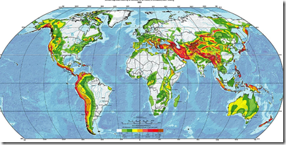
The deep reds in the USGS map below show the areas most at risk of seismic activity, and as you’ll see the boundary where Northern India and the Eurasian plate meet is one the more active regions of the world.

image

Seismically active areas of the world

Earthquakes strike without warning, and literally billions of people live on, or near seismic zones.   Millions more live within range of earthquake driven tsunamis. The ground beneath one’s feet can violently shift in an instant, making it imperative that you, your family, and your business are prepared.


Working to improve earthquake awareness, preparation, and safety is Shakeout.org, which promotes yearly earthquake drills and education around the country (see NPM13: A Whole Lotta Shakeouts Going On).  If you live in one of these seismically active areas, I would encourage you to take part in these yearly drills.

image

Every home should have no less than a 72-hour supply of emergency food and water, for all of its occupants (including pets!).  This is a bare minimum, here in the United States many agencies and organizations recommend that households work towards having a 10-day supply of food, water, and emergency supplies on hand.


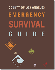
In When 72 Hours Isn’t Enough, I highlighted  a colorful, easy-to-follow, 100 page `survival guide’ released by Los Angeles County, that covers everything from earthquake and tsunami preparedness, to getting ready for a pandemic.

image

While admittedly California-threat specific, this useful guide may be downloaded here (6.5 Mbyte PDF).

For more information on emergency preparedness, I would invite you  to visit:

FEMA http://www.fema.gov/index.shtm

READY.GOV http://www.ready.gov/

AMERICAN RED CROSS http://www.redcross.org/

And some of my preparedness blogs, including:

NPM14: The Advantages Of Having A Shaky Preparedness Plan

The Gift Of Preparedness – 2014 Edition

In An Emergency, Who Has Your Back?

Monday, March 09, 2015

Four Years After Japan’s Great Earthquake & Tsunami

image +

Credit NHK News – Fukushima evacuation zone March 2011


# 9798


This week marks the fourth anniversary of Japan’s greatest modern natural disaster, and as the following Red Cross summary shows, thousands of (mostly elderly) people are still displaced, and for many life remains far from normal.  


First the statement, then I’ll be back with more on the long-term effects of disasters.


Great East Japan Earthquake and Tsunami – 4 years on. Despite progress in recovery, Red Cross continues to address high levels of vulnerability amongst survivors
2015/03/09

Four years have now passed since the Great East Japan Earthquake and Tsunami devastated large areas of Eastern Japan and while much progress has been made in overall recovery, there are serious delays in rebuilding communities, and the Red Cross continues to support thousands of mainly elderly survivors who still live in temporary housing. The tsunami also caused meltdown at the Fukushima Daiichi nuclear plant forcing the evacuation of large numbers of people who will not be able to return home in the foreseeable future because of radioactive contamination.

“There has been considerable progress in overall recovery from the devastation,” said Tadateru Konoe, President of the Japanese Red Cross (JRCS) and of the International Federation of Red Cross and Red Crescent Societies (IFRC), “however, there have been critical delays in rebuilding communities back and particular attention must be given to the needs of many elderly and other vulnerable people who have been unable to get back on their feet. The Red Cross will continue to support them.”

Clean-up efforts have reduced the levels of radioactivity around the Fukushima nuclear power plant, but areas close to the reactor will remain uninhabitable for years to come. With support from the IFRC and national Red Cross & Red Crescent societies around the world, the JRCS continues to provide extensive support to those displaced by the Fukushima meltdown, including health services and psychosocial support. Meanwhile the IFRC is supporting the newly established JRCS Nuclear Disaster Resource Center, which operates a digital library that collects information and experiences related to the nuclear disaster. The center has also drafted an operational manual which will be referred to in developing the IFRC’s guideline for nuclear emergency preparedness.

The Japanese Red Cross has been instrumental in the rebuilding of hospitals, nursery homes, and other vital institutions, and most of these large scale projects are either finished or nearing completion. The rebuilding of permanent homes for the affected population has not progressed as quickly, mainly due to constraints in land acquisition, but several Red Cross supported housing projects for elderly people have been constructed.

Whereas the living conditions of younger generations have by now mostly returned to normal, the situation is more serious for a large number of elderly people who lack a supporting family network and have not yet been able to restore their lives. The Red Cross maintains a focus on providing services to displaced elderly people who need assistance. This includes organizing social activities for residents of both temporary and permanent housing projects.

In addition to the mostly completed large scale construction projects the Japanese Red Cross Society continues to provide medical services, psychosocial support and other assistance to affected people in Iwate, Miyagi and Fukushima prefectures.

(Continue . . . )


Although a relatively rich country, Japan is still rebuilding after the devastation of the earthquake/tsunami/nuclear accident four years later, and the decommissioning of the Fukushima plant will take many more years.   


In Haiti, which suffered a horrific 7.0 earthquake in January of 2010, at last report more than 80,000 people still live in makeshift tent cities, often without running water or adequate sanitation (see USA Today Voices: Haiti, still suffering 5 years after earthquake).  


Although news headlines, and the public’s interest in disasters tend to wane and move to the next big story relatively quickly, recovery from disasters like these - and others like Hurricane Sandy in New York & New Jersey, tornadoes in Joplin and Tuscaloosa, and typhoons in the Philippines – can often take years.


Underappreciated is the toll these disasters can have on the mental and physical health of those heavily affected, and that those effects can continue for years. 


While often hidden from view, the psychological impact of a disaster can be enormous and ongoing.


Three years ago, in  Post Disaster Stress & Suicide Rates we looked at the impact of disaster-related PTSD (Post Traumatic Stress Disorder). This has been recognized as such a pressing problem that in 2013 the World Health Organization released a comprehensive Guidelines For Post-Trauma Mental Health Care book on the treatment of PTSD, acute stress, and bereavement:

image

While the psychological impact of a major disaster cannot be completely mitigated, encouraging individual, family, and business preparedness can go a long ways towards reducing the impact of any disaster.


FEMA, Ready.gov, along with organizations like the American Red Cross (and indeed, this blog), spend a great deal of time trying to convince individuals, families, businesses and communities of the value of preparing for a wide variety of emergencies and disasters.
image

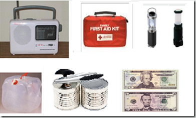
Basic kit : NWS radio, First Aid Kit, Lanterns, Water & Food & cash


Having a modest supply of food, water, and medicine – and a workable family or business disaster plan – can go a long ways toward reducing both stress and hardship during and after a disaster. The standard advice is that everyone needs to be prepared to deal with a disaster for at least 3 days (meaning having a first aid kit, emergency supplies, and a plan) before help arrives.


Sure . . .  they’d like you to be prepared for longer . . .  but 72 hours is a reasonable start. I personally advocate having 2 week’s worth of supplies, but then I live in the heart of hurricane country, and have a fondness for eating regularly (see NPM11: Living The Prepared Life). 


Although a good disaster plan and emergency kit are imperative to get you through the opening hours, days, or even weeks of a disaster, knowing how to help friends, family, and neighbors deal with the psychological effects of a disaster can be equally important.


A few resources you may wish to revisit:


In Psychological First Aid: The WHO Guide For Field Workers we looked a simple guidebook anyone can use to help others in emotional distress.


The CDC also provides a website which contains a number of resources devoted to coping with disasters.

Coping With a Disaster or Traumatic Event

Trauma and Disaster Mental Health Resources

The effects of a disaster, terrorist attack, or other public health emergency can be long-lasting, and the resulting trauma can reverberate even with those not directly affected by the disaster. This page provides general strategies for promoting mental health and resilience. These strategies were developed by various organizations based on experiences in prior disasters.


For more on disaster preparedness, you may wish to revisit:


When 72 Hours Isn’t Enough

In An Emergency, Who Has Your Back?

An Appropriate Level Of Preparedness

The Gift Of Preparedness – 2014 Edition

Tuesday, December 09, 2014

Los Angeles Unveils Earthquake Retrofit & Resilience Plan

image

Resilient By Design PDF


# 9424


Last December, in Dr. Lucy Jones: `Imagine America Without Los Angeles’, we looked at a presentation given by noted seismologist Dr. Jones at the  annual meeting of the American Geophysical Union (held  in San Francisco),  that emphasized that should the `big one’ hit Southern California, we could literally `lose’ Los Angeles.


Dr. Jones warned that the damage could be far greater, and last much longer, than most people believe.  While 99 out of 100 modern buildings might remain standing, the (often buried) infrastructure needed to provide water, electricity, internet connectivity, and natural gas – the lifeblood -  to the region could be devastated (see CBS News report).


Similarly, last year in California Quakes : Concrete Concerns, we looked at a report citing the vulnerability of more than 1,000 older concrete buildings in Los Angeles, many of which could collapse during a strong earthquake.


The authors (Rong-Gong Lin II, Rosanna Xia and Doug Smith) stated that the city has been aware of the dangers for decades, but has refused to require building owners to retrofit their properties for earthquake safety, despite the fact that the area is believed `overdue’ for a major earthquake.


While the timing of the next big quake in Southern California is unknown, in 2010 (see Revised Risk Of `The Big One’ Along San Andreas Fault) we looked at a study that suggested that Southern California may be more overdue for another major quake than previously thought.


The following year, in  Estimating The Economic Impact Of A San Andreas Quake, we looked at a report from the U.S. Bureau of Labor Statistics that endeavored to gauge the crippling impact that a highly feasible 7.8 magnitude Southern California earthquake would have on jobs and local businesses.

image

Download PDF file

A quake of this magnitude, they estimate, could affect  430,000 businesses and 4.5 million workers and deliver a devastating – and prolonged – blow to the local and national economy.


Yesterday the Mayor of Los Angeles, along with Dr. Lucy Jones, unveiled a 126 page plan called Resilient By Design that, among other things, seeks to address  four primary areas of seismic vulnerability


  • Pre-1980 `non-ductile reinforced concrete’ buildings
  • Pre-1980 `soft-first-story’ buildings
  • Water system infrastructure (including impact on Firefighting capability)
  • Telecommunications Infrastructure


In addition to finding a `quake-resilient’ way to deliver water to firefighters after an earthquake, and building a `solar-powered, city-wide WiFi network’ to keep the city connected after a disaster, the plan calls for major retrofits of thousands of existing vulnerable buildings to prevent their collapse.


Pre-1980 wooden soft-first story buildings retrofits would have to take place within five years while mandatory strengthening of hundreds of pre-1980 concrete buildings would have to happen within 30 years. While expensive, tax breaks would be offered to building owners to help ease the cost of reinforcing their structures.  


L.A. Mayor, Eric Garcetti, explains the sweeping plan in his Mayor’s blog, where he writes:

These action steps are designed to be best-in-class and achievable. This is not intended to simply be the latest “blue ribbon commission” report that sits on a shelf. It’s designed so that government, property owners, and commercial and residential tenants can come together to strengthen Los Angeles against a known and major threat to life, property, and our economy.


While admittedly a local story, Los Angeles isn’t the only major U.S. city  that lies in an active seismic zone; Memphis, St. Louis, Charleston, Seattle, Portland, San Francisco, Salt Lake City  . . . even New York City, all have varying degrees of seismic risks.  

image

Seismic Hazard Map – Credit USGS


While we can’t prevent natural disasters, we can prepare for them  You may not be able to do anything personally about the risks to local infrastructure, but you can ensure that you and your family have the supplies to survive for days (or better yet, a couple of weeks) if these vital services are cut or destroyed. 


Working to improve earthquake awareness, preparation, and safety is Shakeout.org, which promotes yearly earthquake drills and education around the country (see NPM13: A Whole Lotta Shakeouts Going On).  If you live in one of these seismically active areas, I would encourage you to take part in these yearly drills.

image


For more information on emergency preparedness, I would invite you  to visit:

FEMA http://www.fema.gov/index.shtm

READY.GOV http://www.ready.gov/

AMERICAN RED CROSS http://www.redcross.org/

And some of my preparedness blogs, including:

When 72 Hours Isn’t Enough

The Gift Of Preparedness – 2014 Edition

In An Emergency, Who Has Your Back?

Friday, September 05, 2014

NPM14: The Advantages Of Having A Shaky Preparedness Plan

image

2014 Update of the United States National Seismic Hazard Maps


# 9040


Although I’ve lived most of my life in Florida - one of the few regions of the United States with little or no seismic risk - I did spend a decade living within spitting distance of the New Madrid fault (well inside the red bulls eye in the middle of the map above).


While earthquakes were always a concern, the added hazards of ice storms, floods (we lived on a river), and tornadoes also spurred us to stay prepared.


And while we never experienced the `big one’, there were certainly occasions when we were glad we had at least a couple of weeks of food in the pantry, battery operated lanterns, a windup radio, and enough water stored to last a week (we also had a river, two springs, and a water filter as a backup).


The recent M6.0 Quake That Rattled Region North Of San Francisco was but a small taste of what will happen to a great American city at some point in the future.  Like pandemics, earthquakes along fault lines are inevitable.  It is just the timing that is unknown.


Last December, in Dr. Lucy Jones: `Imagine America Without Los Angeles’, we looked at a presentation given by Dr. Jones at the  annual meeting of the American Geophysical Union (held this year in San Francisco),  that emphasized that should the `big one’ hit Southern California, we could literally `lose’ Los Angeles.


She warned that the damage could be far greater, and last much longer, than most people believe.  While 99 out of 100 modern buildings might remain standing, the (often buried) infrastructure needed to provide water, electricity, internet connectivity, and natural gas – the lifeblood -  to the region could be devastated (see CBS News report).


f this sounds like hyperbole to you, in 2010 (see Revised Risk Of `The Big One’ Along San Andreas Fault) we looked at a study that suggested that Southern California may be more overdue for another major quake than previously thought.


And in 2011 (see Estimating The Economic Impact Of A San Andreas Quake) we looked at a report from the U.S. Bureau of Labor Statistics that endeavored to gauge the crippling impact that a highly feasible (and long overdue) 7.8 magnitude Southern California earthquake would have on jobs and local businesses.

image

Download PDF file

A quake of this magnitude, they estimate, could affect  430,000 businesses and 4.5 million workers and deliver a devastating – and prolonged – blow to the local (and national) economy.


What may be even a greater threat lurks along the Cascadia Fault line, which runs parallel to the Pacific Northwest Coastline, and has a long history of a producing major earthquakes and tsunamis, the last one in the year 1700.

image

The geological record indicates massive quakes have struck the region at least 7 times over the past 3500 years. If we wait long enough, another is sure to strike again.  We looked at the threats posed by this particular fault line back in 2011 in Just A Matter Of Time.


Although large earthquakes in the Eastern half of the United States have been recorded in the past (including the Charleston, SC earthquake of 1886), the August 2011 5.8 earthquake that rocked Virginia and the Nation’s capital (see USGS Statement On The Virginia Earthquake) provided fresh evidence not only of their potential to occur,  but also how widely felt they may be (see USGS: Eastern Earthquakes - Rare But Powerful).


Another strong quake hit the Heartland a few months later (see 5.6 Mag Quake Rattles Oklahoma), and since then, the number of quakes in north central Oklahoma have increased to the point that last May, the USGS/OGS issued a Joint Statement On Increased Earthquake Threat To Oklahoma warning of the risks of a bigger damaging quake.

image

USGS-OGS Oklahoma Earthquake Activity


And if all this weren’t enough, seismic threats extend beyond just earthquakes


They encompass volcanic eruptions (see Washington State: Volcano Awareness Month) - and Tsunamis – both of which have the ability to affect both people and property thousands of miles away from the originating event  (see The USGS West Coast Tsunami Scenario Report & East Coast Tsunami Threats).


Even though the majority of Americans live in a seismically active region of the country, few are really prepared to deal with the aftermath of a major quake.  As a bare minimum, everyone should have a well thought out disaster and family communications plan, along with a good first aid kit, a `bug-out bag’, and sufficient emergency supplies to last at least 72 hours.


In When 72 Hours Isn’t Enough, I highlighted  a colorful, easy-to-follow, 100 page `survival guide’ released by Los Angeles County, that covers everything from earthquake and tsunami preparedness, to getting ready for a pandemic.

image

The guide may be downloaded here (6.5 Mbyte PDF).

While designed specifically for the nearly 10 million residents of Los Angeles County, this guide would be a valuable asset for anyone interested in preparing for a variety of hazards. And in Los Angeles, the advice is to have emergency supplies (food, water, etc) to last up to 10 days. In my humble opinion, 2-weeks in an earthquake zone isn’t overkill.


Working to improve earthquake awareness, preparation, and safety is Shakeout.org, which promotes yearly earthquake drills and education around the country (see NPM13: A Whole Lotta Shakeouts Going On).  If you live in one of these seismically active areas, I would encourage you to take part in these yearly drills.

image


As September is National Preparedness Month, now is  an opportune time to become better prepared as an individual, family, business owner, or community to deal with all types of disasters   I would invite you to visit the following preparedness sites.


FEMA http://www.fema.gov/index.shtm

READY.GOV http://www.ready.gov/

AMERICAN RED CROSS http://www.redcross.org/


And lastly, in NPM13: The Greatest Prep Of All,  I wrote about what I consider to be the most important preparedness step you can take – having, and being,  a disaster buddy.  Cultivating a network of family and friends to whom you can turn for help in a disaster, to who can turn to you for aid,  if they need it.


Because no matter where you live, its just a matter of time before the next disaster strikes.

Sunday, August 03, 2014

M6.1 Quake In China – Heavy Damage & Fatalities Reported

 image


# 8909


A strong (reports vary M6.1 USGS to M6.5 from China) earthquake has struck a fairly populated region of central China, and there are media reports (see BBC Earthquake 'kills 150' in south-west China) indicating severe damage and significant loss of life.

Tuesday, May 06, 2014

USGS/OGS Joint Statement On Increased Earthquake Threat To Oklahoma

image

USGS-OGS Oklahoma Earthquake Activity


# 8577


In 2009, after decades of little or no serious seismic activity, the number of earthquakes in Oklahoma began tor rise.  In 2011, a 5.6 Mag Quake Rattled Oklahoma, which was the strongest quake in that state’s history. Since then, the number of quakes has continued to increase, which has been the subject of several blogs here at AFD.


USGS: Oklahoma Earthquake Swarm Update

Oklahoma Insurance Commissioner Warns On Earthquake Risks

USGS: Oklahoma Earthquake Swarm Continues


While 2013 was a record year for Oklahoma quakes over M3.0, the first 5 months of 2014 have produced quakes at more than twice last year’s rate, leading the USGS and the Oklahoma Geological Survey  (OGS) to issue a joint statement on the ongoing earthquake risk in that state.


First a link, and a few excerpt from that statement, after which I’ll return with more.


Record Number of Oklahoma Tremors Raises Possibility of Damaging Earthquakes

oklahoma-geological-survey Updated USGS-Oklahoma Geological Survey Joint Statement on Oklahoma Earthquakes
Originally Released: 10/22/2013 1:07:59 PM; Updated May 2, 2014

The rate of earthquakes in Oklahoma has increased remarkably since October 2013 – by about 50 percent – significantly increasing the chance for a damaging magnitude 5.5 or greater quake in central Oklahoma.

View map of Oklahoma seismicity.
View animation of Oklahoma Seismicity.

A new U.S. Geological Survey and Oklahoma Geological Survey analysis found that 145 earthquakes of magnitude 3.0 or greater occurred in Oklahoma from January 2014 (through May 2; see accompanying graphic). The previous annual record, set in 2013, was 109 earthquakes, while the long-term average earthquake rate, from 1978 to 2008, was just two magnitude 3.0 or larger earthquakes per year. Important to people living in central and north-central Oklahoma is that the likelihood of future, damaging earthquakes has increased as a result of the increased number of small and moderate shocks.

Oklahoma’s heightened earthquake activity since 2009 includes 20 magnitude 4.0 to 4.8 quakes, plus the largest earthquake in Oklahoma’s history – a magnitude 5.6 earthquake that occurred near Prague on Nov. 5, 2011. The 2011 Prague earthquake damaged a number of homes and the historic Benedictine Hall at St. Gregory's University in Shawnee. Prior to the 2011 Prague earthquake, the largest earthquake of Oklahoma’s history was a magnitude 5.5 earthquake that occurred in 1952 near El Reno and damaged state buildings in Oklahoma City.

“While it’s been known for decades that Oklahoma is ‘earthquake country’, we hope that this new advisory of increased hazard will become a crucial consideration in earthquake preparedness for residents, schools and businesses in the area,” said Dr. Bill Leith, Senior Science Advisor for Earthquakes and Geologic Hazards at USGS. “Building owners and government officials should have a special concern for older, unreinforced brick structures, which are vulnerable to serious damage during sufficient shaking.”

(Continue . . .)


While no specific predictions as to time, location, or intensity are offered, these agencies believe there is a heightened risk for larger, potentially damaging earthquakes in Oklahoma – at least in the near term.


The bottom line is that Oklahomans (and anyone else who lives an a seismically active region) need to seriously include earthquake preparedness as part of their overall emergency plans.


The State of Oklahoma maintains an earthquake safety webpage at EARTHQUAKE SAFETY,  while additional Oklahoma specific earthquake monitoring and research information can be found at the Oklahoma Geological Survey.


Although the west coast is most noted for its seismic hazards, much of America’s heartland and parts of the Eastern Seaboard are also susceptible to moderate to strong quakes.   A topic I covered more than a year ago in USGS: Eastern Earthquakes - Rare But Powerful.


image


At a bare minimum, every household should have a disaster plan, a good first aid kit (and the knowledge to use it), an emergency battery operated NWS weather radio, and emergency supplies to last a minimum of 72 hours during a disaster.To become better prepared as an individual, family, business owner, or community, I would invite you to visit the following preparedness sites.

FEMA http://www.fema.gov/index.shtm

READY.GOV http://www.ready.gov/

AMERICAN RED CROSS http://www.redcross.org/


For more on increasing your level of preparedness, a partial list of some of my preparedness blogs include:

When 72 Hours Isn’t Enough

In An Emergency, Who Has Your Back?

An Appropriate Level Of Preparedness

Saturday, April 12, 2014

7.6M Quake Solomon Islands: No Pacific Wide Tsunami Expected

image

Credit USGS 


# 8466


A shallow (10km) and fairly large (M7.6 – 7.8) earthquake has struck in the Solomon Islands.  While we are awaiting reports, here is a link and excerpts from the Tsunami bulletins being issued by the Pacific Tsunami Warning Center.  


Note: This earthquake was originally reported as an 8.4, but has been downgraded. At this only local warnings have been issued.

BASED ON ALL AVAILABLE DATA A DESTRUCTIVE PACIFIC-WIDE TSUNAMI IS NOT EXPECTED AND THERE IS NO TSUNAMI THREAT TO HAWAII. REPEAT. A DESTRUCTIVE PACIFIC-WIDE TSUNAMI IS NOT EXPECTED AND THERE IS NO TSUNAMI THREAT TO HAWAII. - LINK


WEPA40 PHEB 122035
TSUPAC

TSUNAMI BULLETIN NUMBER 002


PACIFIC TSUNAMI WARNING CENTER/NOAA/NWS
ISSUED AT 2035Z 12 APR 2014

THIS BULLETIN APPLIES TO AREAS WITHIN AND BORDERING THE PACIFIC OCEAN AND ADJACENT SEAS...EXCEPT ALASKA...BRITISH COLUMBIA... WASHINGTON...OREGON AND CALIFORNIA.

... A TSUNAMI WARNING IS IN EFFECT ...

THE MAGNITUDE HAS BEEN REVISED FROM 8.3 DOWN TO 7.8 IN THIS MESSAGE AND THE WARNING AREA HAS BEEN REDUCED.

A TSUNAMI WARNING IS IN EFFECT FOR

SOLOMON ISLANDS / VANUATU / PAPUA NEW GUINEA FOR ALL OTHER AREAS COVERED BY THIS BULLETIN... IT IS FOR INFORMATION ONLY AT THIS TIME.

THIS BULLETIN IS ISSUED AS ADVICE TO GOVERNMENT AGENCIES.  ONLY NATIONAL AND LOCAL GOVERNMENT AGENCIES HAVE THE AUTHORITY TO MAKE DECISIONS REGARDING THE OFFICIAL STATE OF ALERT IN THEIR AREA AND ANY ACTIONS TO BE TAKEN IN RESPONSE.

AN EARTHQUAKE HAS OCCURRED WITH THESE PRELIMINARY PARAMETERS   

ORIGIN TIME -  2015Z 12 APR 2014 

COORDINATES -  11.3 SOUTH  162.3 EAST

DEPTH       -   33 KM

LOCATION    -  SOLOMON ISLANDS

MAGNITUDE   -  7.8

EVALUATION

IT IS NOT KNOWN THAT A TSUNAMI WAS GENERATED.  THIS WARNING IS  BASED ONLY ON THE EARTHQUAKE EVALUATION. AN EARTHQUAKE OF THIS  SIZE HAS THE POTENTIAL TO GENERATE A DESTRUCTIVE TSUNAMI THAT CAN  STRIKE COASTLINES IN THE REGION NEAR THE EPICENTER WITHIN MINUTES  TO HOURS. AUTHORITIES IN THE REGION SHOULD TAKE APPROPRIATE ACTION IN RESPONSE TO THIS POSSIBILITY. THIS CENTER WILL MONITOR  SEA LEVEL GAUGES NEAREST THE REGION AND REPORT IF ANY TSUNAMI  WAVE ACTIVITY IS OBSERVED. THE WARNING WILL NOT EXPAND TO OTHER  AREAS OF THE PACIFIC UNLESS ADDITIONAL DATA ARE RECEIVED TO
WARRANT SUCH AN EXPANSION.

Wednesday, April 02, 2014

USGS Warns On Fake Earthquake Alert

image

Earthquake Hoax warning from the USGS


#8424


With a couple of medium-sized temblors in Los Angeles in recent weeks, an ongoing swarm of quakes in Oklahoma, and another medium-sized temblor last week in Yellowstone, I guess it was inevitable that the prognosticators of perpetual doom on the internet would begin to predict that California was about to fall into the Pacific, or that the Yellowstone Supervolcano would destroy the North American continent.


These are always popular memes on the internet, and are aided and abetted by disastertainment cable-TV `documentaries’  like Doomsday Preppers, and Mega-Disasters.


Most people are savvy enough to discount these predictions as having no scientific merit, but when they come on what purports to be a USGS letterhead, they are more likely to be taken seriously. 


And that, unfortunately, is exactly what has happened over the past few days as a fake USGS warning has been emailed (and no doubt breathlessly forwarded) predicting a impending major earthquake in California.

image

Fake Earthquake Warning 


As far as predicting earthquakes, the USGS has this to say:


Can you predict earthquakes?

No. Neither the USGS nor any other scientists have ever predicted a major earthquake. They do not know how, and they do not expect to know how any time in the foreseeable future. However based on scientific data, probabilities can be calculated for potential future earthquakes. For example, scientists estimate that over the next 30 years the probability of a major EQ occurring in the San Francisco Bay area is 67% and 60% in Southern California.The USGS focuses their efforts on the long-term mitigation of earthquake hazards by helping to improve the safety of structures, rather than by trying to accomplish short-term predictions.

Learn more: Earthquake Prediction


While short term predictions such as the one in the hoax letter are best ignored, the reality is that earthquakes can and do happen, and those who live in seismically active regions need to be prepared to deal with them.  


This from California’s Earthquake Preparedness Website:

image

April is Earthquake Preparedness Month, it has been recognized since the April 1906 San Francisco earthquake and continues to be supported by the state assembly urging all Californians and government agencies to engage in education, evaluation of seismic hazards, mitigation, safety activities, and the exchange of information related to earthquake preparedness with other states and nations.

Surprisingly, many Californians don't consider themselves at risk unless they live on or near the line of a well-known fault, such as the San Andreas or Hayward Fault. This misconception leaves millions of Californians unprepared for an earthquake.

Quick Facts:

  • Major earthquakes registering magnitudes between 6.3 and 8.3 have occurred in California every 5.4 years, on average, for the past 200 years.
  • The United States Geological Survey estimates that there is a 90 percent chance that a major earthquake will strike an urban area in California within the next 30 years.
  • The majority of Californians live within 20 miles of a major earthquake fault.
  • Being prepared could save your life!

While California is a world leader in emergency response and recovery capabilities, our responders can't do it alone. It is the responsibility of every individual to take action, get informed, and get actively involved in emergency preparedness.

(Continue . . .)

For more information I would encourage you to visit:

FEMA http://www.fema.gov/index.shtm

READY.GOV http://www.ready.gov/

AMERICAN RED CROSS http://www.redcross.org/

A few of my (many) blogs on disaster preparedness include:

  • In An Emergency, Who Has Your Back?
  • When 72 Hours Isn’t Enough
  • When Evacuation Is The Better Part Of Valor
  • Saturday, March 29, 2014

    Los Angeles M5.1: Californians Shaken & Hopefully Stirred

    image


    # 8413


    Overnight, and as 2014’s National Tsunami Preparedness Week winds down,  the city of Los Angeles was rocked by a moderately strong earthquake (Mag 5.1), causing some minor damage and rattling nerves across a wide swath of Southern California.   Three hours after the quake, the Los Angeles Times was reporting 5.1 earthquake causes damage; some flee from homes.


    While a far cry from `the big one’, California residents are advised by USGS seismologist Lucy Jones that there is about a 5% chance that this quake could be a foreshock, and that another – larger quake – could occur in the hours or days ahead (Larger L.A. earthquake possible after 5.1 temblor, USGS says).


    First the Tectonic Summary from the USGS, then I’ll be back with a bit more about earthquake preparedness.


    image

    Tectonic Summary

    A M5.1 earthquake occurred at 9:09PM on March 28, 2014, located 1 mile easy of La Habra, CA, or 4 miles north of Fullerton, CA. The event was felt widely throughout Orange, Los Angeles, Ventura, Riverside, and San Bernardino counties.  It was preceded by two foreshocks, the larger of M3.6 at 8:03pm.  The demonstration earthquake early warning system provided 4 second warning in Pasadena. 

    There have been 23 aftershocks as of 10:00PM on March 28, the largest of which was a M3.6 at 9:30PM, and was felt locally near the epicenter. The aftershock sequence may continue for several days to weeks, but will likely decay in frequency and magnitude as time goes by.

    The maximum observed instrumental intensity was VII, recorded in the LA Habra and Brea areas, although the ShakeMap shows a wide area of maximum intensity of VI. The maximum reported intensity for the Did You Feel It? map was reported at VI in the epicentral area.

    This sequence could be associated with the Puente Hills thrust (PHT).  The PHT is a blind thrust fault that extends from this region to the north and west towards the City of Los Angeles.  It caused the M5.9 1987 Oct. 1 Whittier Narrows earthquake. 

    Previously, the M5.4 2008 Chino Hills earthquake occurred in this region.  It caused somewhat stronger shaking in Orange County and across the Los Angeles Basin. 

    The moment tensor shows oblique faulting, with a north dipping plane that approximately aligns with the Puente Hills thrust.


    Last December, in Dr. Lucy Jones: `Imagine America Without Los Angeles’, we looked at a presentation given by Dr. Jones at the  annual meeting of the American Geophysical Union (held this year in San Francisco),  that emphasized that should the `big one’ hit Southern California, we could literally `lose’ Los Angeles.


    She warned that the damage could be far greater, and last much longer, than most people believe.  While 99 out of 100 modern buildings might remain standing, the (often buried) infrastructure needed to provide water, electricity, internet connectivity, and natural gas – the lifeblood -  to the region could be devastated (see CBS News report).


    If this sounds like hyperbole, in 2010 (see Revised Risk Of `The Big One’ Along San Andreas Fault) we looked at a study that suggested that Southern California may be more overdue for another major quake than previously thought, and in the following year (see Estimating The Economic Impact Of A San Andreas Quake) we looked at a report from the U.S. Bureau of Labor Statistics that endeavored to gauge the crippling impact that a highly feasible (and long overdue) 7.8 magnitude Southern California earthquake would have on jobs and local businesses.

    image

    Download PDF file

    A quake of this magnitude, they estimate, could affect  430,000 businesses and 4.5 million workers and deliver a devastating – and prolonged – blow to the local (and national) economy.


    For a comprehensive guide on how you can prepare for `the big one’ (even if you live someplace other than Los Angeles), I would recommend you download, read, and implement the advice provided by the The L. A. County Emergency Survival Guide.  


    As you’ll notice, Los Angeles recommends having more than just a 72 hour emergency kit.

    image

    It isn’t enough to have a kit, and a plan during an earthquake. You need to know what to do to protect life and limb while the shaking is going on.  And for that, we have the ever-growing Great Shakeout Drill (see  NPM13: A Whole Lotta Shakeouts Going On).

    image


    While there is admittedly a 95% chance that there won’t be a large aftershock to this quake, it only takes being caught unprepared for a single major disaster to ruin your entire day.


    For more information on emergency preparedness, I would invite you  to visit:

    FEMA http://www.fema.gov/index.shtm

    READY.GOV http://www.ready.gov/

    AMERICAN RED CROSS http://www.redcross.org/

    And some of my preparedness blogs, including:

    When 72 Hours Isn’t Enough

    The Gift Of Preparedness: 2013

    In An Emergency, Who Has Your Back?

    Wednesday, March 05, 2014

    USGS: Oklahoma Earthquake Swarm Update

    image

    M2.5+  Swarm last 7 Days -  Credit USGS  Earthquake Map


    # 8351


    Last November, in Oklahoma Insurance Commissioner Warns On Earthquake Risks,  I wrote about the recent uptick in moderate earthquake activity in and around Oklahoma City, OK which began in earnest back in 2009. This `swarm’ includes the largest earthquake ever reported in Oklahoma, a 5.6 Mag Quake near Prague on Nov. 5, 2011.


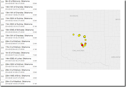
    While most of Oklahoma’s temblors since then have come in under 4.0, on average they’ve seen at least a couple of 2.5+ quakes every day for the past month.  Not strong enough to cause significant damage, but strong enough to be felt, and to raise concerns.


    Today, the USGS is reporting a M3.9 - 9km E of Edmond, Oklahoma, the strongest temblor in that region since February 8th’s M4.1 quake. 


    Earlier this year, the USGS produced the following update, which links the increase in earthquake activity in the Midwest and East to induced seismicity – or man-made causes.

    Man-Made Earthquakes Update

    Categories: Featured, Natural Hazards
    Posted on January 17, 2014 at 1:00 pm
    Last update 2:03 pm By: William Ellsworth (ellsworth@usgs.gov), Jessica Robertson (jrobertson@usgs.gov), and Christopher Hook (703-648-4460)

    Seismicity of the coterminous United States and surrounding regions, 2009–2012. Black dots denote earthquakes with a magnitude ≥ 3.0 are shown; larger dots denote events with a magnitude ≥ 4.0. Background colors indicate earthquake hazard levels from the U.S. National Seismic Hazard Map (NSHM). Learn more about the NSHM at http://earthquake.usgs.gov/hazards/?source=sitenav.

    Seismicity of the coterminous United States and surrounding regions, 2009–2012. Black dots denote earthquakes with a magnitude ≥ 3.0 are shown; larger dots denote events with a magnitude ≥ 4.0. Background colors indicate earthquake hazard levels from the U.S. National Seismic Hazard Map (NSHM). Learn more about the NSHM at http://earthquake.usgs.gov/hazards/?source=sitenav.


    The number of earthquakes has increased dramatically over the past few years within the central and eastern United States. Nearly 450 earthquakes magnitude 3.0 and larger occurred in the four years from 2010-2013, over 100 per year on average, compared with an average rate of 20 earthquakes per year observed from 1970-2000.

    This increase in earthquakes prompts two important questions: Are they natural, or man-made? And what should be done in the future as we address the causes and consequences of these events to reduce associated risks? USGS scientists have been analyzing the changes in the rate of earthquakes as well as the likely causes, and they have some answers.

    USGS scientists have found that at some locations the increase in seismicity coincides with the injection of wastewater in deep disposal wells. Much of this wastewater is a byproduct of oil and gas production and is routinely disposed of by injection into wells specifically designed for this purpose.

    Review Article on Injection-Induced Earthquakes

    U.S. Geological Survey geophysicist William Ellsworth reviewed the issue of injection-induced earthquakes in a July 2013 study published in the journal Science. The article focused on the injection of fluids into deep wells as a common practice for disposal of wastewater, and discusses recent events and key scientific challenges for assessing this hazard and moving forward to reduce associated risks.

    What is Induced Seismicity?

    Although it may seem like science fiction, man-made earthquakes have been a reality for decades. It has long been understood that earthquakes can be induced by impoundment of water in reservoirs, surface and underground mining, withdrawal of fluids and gas from the subsurface, and injection of fluids into underground formations.

    (Continue . . . )

    While the scientific debate over the exact cause of, and best remedy for, this increased seismic activity continues, last October the USGS warned (bolding mine):


    Important to people living in the Oklahoma City region is that earthquake hazard has increased as a result of the swarm. USGS calculates that ground motion probabilities, which relate to potential damage and are the basis for the seismic provisions of building codes, have increased in Oklahoma City as a result of this swarm.  While it’s been known for decades that Oklahoma is "earthquake country," the increased hazard has important implications for residents and businesses in the area.


    Which means that Oklahomans (and anyone else who lives an a seismically active region) need to seriously include earthquake preparedness as part of their overall emergency plans. The State of Oklahoma maintains an earthquake safety webpage at EARTHQUAKE SAFETY,  while additional Oklahoma specific earthquake monitoring and research information can be found at the Oklahoma Geological Survey.


    Although the west coast is most noted for its seismic hazards, much of America’s heartland and parts of the Eastern Seaboard are also susceptible to moderate to strong quakes.   A topic I covered more than a year ago in USGS: Eastern Earthquakes - Rare But Powerful


    image


    At a bare minimum, every household should have a disaster plan, a good first aid kit (and the knowledge to use it), an emergency battery operated NWS weather radio, and emergency supplies to last a minimum of 72 hours during a disaster.To become better prepared as an individual, family, business owner, or community, I would invite you to visit the following preparedness sites.


    FEMA http://www.fema.gov/index.shtm

    READY.GOV http://www.ready.gov/

    AMERICAN RED CROSS http://www.redcross.org/

    For more on increasing your level of preparedness, a partial list of some of my preparedness blogs include:

    When 72 Hours Isn’t Enough

    In An Emergency, Who Has Your Back?

    An Appropriate Level Of Preparedness

    Tuesday, February 18, 2014

    Caribbean 6.5 Mag Quake – No Widespread Tsunami Threat

    image

    # 8308


    Just over a month ago, after a pair of earthquakes stuck Cuba (m 5.1) and just north of Puerto Rico (m 6.4), we talked about The Caribbean’s Hidden Tsunami Potential, and its not inconsequential history of seismic events. Earthquakes, major volcanic eruptions, and deadly tsunamis – while rare – are not unheard of across the Caribbean basin.


    Earlier this morning another earthquake – this time pegged by the USGS as a 6.5 magnitude – struck west of Barbados, and while it doesn’t appear to have generated a tsunami or produced any serious damage in the region, reminds us of the destructive potential of such quakes in the region.

    image


    The NWS Pacific Tsunami Warning Center issued the following statement regarding this quake:

    EVALUATION

    A DESTRUCTIVE WIDESPREAD TSUNAMI THREAT DOES NOT EXIST BASED ON HISTORICAL EARTHQUAKE AND TSUNAMI DATA. HOWEVER - THERE IS THE SMALL POSSIBILITY OF A LOCAL OR REGIONAL TSUNAMI THAT COULD AFFECT COASTS LOCATED USUALLY NO MORE THAN A FEW HUNDRED KILOMETERS FROM THE EARTHQUAKE EPICENTER. AUTHORITIES IN THE REGION NEAR THE EPICENTER SHOULD BE MADE AWARE OF THIS POSSIBILITY.


    Early reports from Sky News indicated no damage at the Island’s capital city Bridgetown.


    While rare, READY.GOV has a Tsunami Awareness Page with helpful hints. NOAA  provides several useful documents, including a Tsunami Zone PDF (see below) and Tsunami Web page.

    image


    Tsunami awareness and preparedness for those in living or working in coastal regions is just one facet of what should be an all-threats preparedness plan, designed to handle a wide range of scenarios including tornadoes, hurricanes, floods, earthquakes, and even a pandemic.


    As we move towards the spring severe storm season, and ultimately back into the Atlantic Hurricane season, now is a good time to review and refresh your emergency preparedness plans.


    For more on  disaster preparedness, I would invite you to visit Ready.gov, FEMA,  or revisit these blogs:

    In An Emergency, Who Has Your Back?

    An Appropriate Level Of Preparedness

    The Gift Of Preparedness: 2013