Monday, May 31, 2010

WHO To Review Pandemic Status Tomorrow


# 4611


On June 1st the World Health Organization will convene a special teleconference with their influenza advisory committee to decide on the current status of the pandemic.   We should have some word later in the day as to what they decide.


Here is the Reuters report.


Experts to review status of flu pandemic on Tuesday

GENEVA

Mon May 31, 2010 2:23pm BST

GENEVA (Reuters) - An expert panel that advises the World Health Organization on pandemics will meet Tuesday to decide whether to declare the H1N1 flu outbreak over.


The WHO said in a statement Monday that its emergency committee will begin a teleconference at 1200 GMT Tuesday and results will be posted later in the day on its website.


Earlier this month, a WHO spokesman said the committee would consider three main options.


These would be to conclude that the pandemic was still in force and retain the WHO's current phase 6 on its 6-level pandemic scale; state that pandemic had moved into a transitional "post-peak" phase; or declare that the pandemic was over.


(Continue . . . )

When Oil and Water Do Mix


# 4610


I’ve seen a good deal of speculation in recent days about the impact that the oil spill in the Gulf of Mexico may have on Hurricane season (and vice versa), and so I thought I’d post this two page guide produced by NOAA on the likely effects.


It seems highly unlikely to most experts that the oil spill will affect hurricane development this year.  


Less certain are the effects that gulf storms will have on the oil spill itself.  


They may help mix and `weather’ the oil, increasing the rate of biodegradation. But the winds (and surge tide) could also spread the oil further inland, particularly into the marsh and swamplands, complicating cleanup.


My thanks and a hat tip to FEMA Director Craig Fugate for tweeting this information on Twitter. Follow Craig at CraigatFEMA and of course, FEMAinfocus  for the latest disaster updates.


image

(click to open)

A Host Of Reservoirs


# 4609


Today, another entry in the ever increasing list of animals that can serve as hosts for the influenza A virus.   This time it happens to be a variety of striped skunk (Mephitis mephitis), 8 of which died on a mink farm in Canada last December and January.


Initial necropsy and testing results indicated a mixed bacterial pneumonia (Streptococcus dysgaslactiae subsp. equisimilis, Staphylococcus aureus, and Hafnia alvei)  as the cause of death, but further testing revealed the pneumonia to be secondary to a viral infection by pandemic H1N1 2009.


Further complicating matters, the skunks also tested positive for ADV (Aleutian Disease Virus), a common virus carried by minks, that may have contributed to the severity of the skunk’s infections.


First some excerpts from the CDC EID Journal article (It’s relatively short, so follow the link to read the whole thing), then some commentary.


Volume 16, Number 6–June 2010
Letter

Pandemic (H1N1) 2009 in Skunks, Canada

Ann P. Britton,  Ken R. Sojonky, Andrea P. Scouras, and Julie J. Bidulka


<SNIP>

During mid-December 2009–mid-January 2010, eight striped skunks (Mephitis mephitis) died on a mink farm near Vancouver, British Columbia, Canada. On January 12, 2010, two of the skunks were brought to the Animal Health Centre in Abbotsford, British Columbia, for postmortem examination.


One skunk exhibited purulent nasal exudates. In both skunks, investigators observed splenomegaly and severe pneumonia, characterized by heavy, dark red to purple, lung lobes involving >70% of the lung field. Microscopic examination showed moderate rhinitis and severe bronchopneumonia with intralesional bacteria, areas of interstitial pneumonia, and occasional nematode larvae.


<SNIP>

Detection of influenza A virus nucleoprotein and matrix genes and hemagglutinin and neuraminidase typing was performed with real-time reverse transcription–PCR. Organ samples were positive for pandemic (H1N1) 2009, which was confirmed by sequence analysis of DNA fragments obtained in the hemagglutinin, neuraminidase, and matrix gene testing.


<SNIP>


In view of the detection of pandemic (H1N1) 2009 virus in 2 striped skunks with fatal pneumonia, this species should now be regarded as a potential source of influenza A virus.


Wild animals participate in the transmission of influenza A viruses between species, and the presence of wildlife on farms is known to be a risk factor for infection of poultry (7). Similar to raccoons, skunks express both α2,3 and α2,6 sialic acid receptors for avian and human influenza viruses in the respiratory tract (M. Shrenzel, San Diego Zoo, pers. comm.), which is believed to create the opportunity for mixed influenza infections with potential for genetic reassortment (8).


Skunks, like raccoons, are highly mobile animals with large home ranges in rural and urban areas, which provides numerous opportunities for influenza A virus exposure and transmission to poultry, livestock, pets, and, ultimately, humans. The inclusion of striped skunks in wildlife influenza surveillance programs may be warranted.


Influenza viruses must reside in a living host in order to replicate and survive.   Outside of a suitable host environment, the influenza virus can only survive for a limited amount of time.


In order to infect a host, a virus must attach itself to cells in the host’s body.  Influenza viruses have an affinity for either the alpha 2,3 receptor cell or the alpha 2,6 receptor cell.


Avian adapted influenza viruses bind preferentially to Alpha 2,3 receptor cells, which are commonly found in the digestive tract of birds.  This explains why most avian flu viruses are gastrointestinal infections in birds. 


Human adapted viruses have an affinity for the alpha 2,6 receptor cell, which populate the upper airway and lungs.  This is why influenza is a respiratory virus in humans.


There are some crossovers in receptor cells, and humans have some avian-like alpha 2,3 receptor cells, particularly deep in the lungs.  It is harder for avian influenzas to reach those cells, but not impossible.


Some species, like pigs, have an abundance of both types of receptor cells, and thus make good mixing vessels for human and avian adapted viruses.  


If a pig (or any other host) is simultaneously infected with two different flu viruses, it is possible for the viruses to swap genetic material (via reassortment) and create a new, hybrid virus.


Reassortant


For more on how influenza viruses are thought to bind to cells, you might wish to revisit:


Study: H1N1 Receptor Binding
RBD: Looking For The Sweet Spot
Receptor Binding Domains: Take Two


Last January I wrote a blog entitled Mixing Vessels For Influenza  which mentioned research done by two wildlife disease experts from the San Diego Zoo - Mark Schrenzel and Bruce Rideout – that identified the North American Striped Skunk - along with a handful of other small carnivores - as a potential host for influenza reassortment.


The striped skunk, like the pig, has both types of receptors cells.


Over the past few years we’ve seen reports of H5N1 (bird flu) infections  among dogs, cats, civets, raccoons, martens, and – of course – humans.   Additionally, researchers have successfully infected cattle with the H5N1 virus, along with ferrets and mice for testing.


Pandemic H1N1 flu has been documented in humans, swine, turkeys, skunks, ferrets, cats, and dogs.  For a listing of animal pandemic flu reports you can visit the AVMA Pandemic Flu page.


The fact that skunks, and civets, and raccoons are susceptible to influenza may seem inconsequential, but small mammals that can carry influenza viruses can become difficult biosecurity problems on poultry farms, and may serve as a conduit for bird flu viruses.  


Additionally, they provide yet another reservoir, and perhaps another opportunity for flu viruses to mutate or reassort.


While successful reassortments (biologically competitive and `fit’) don’t happen very often, when they do, they pose a significant threat to a variety of species, including humans. 


Reason enough to ramp up our surveillance in farmed animals and wildlife.

Sunday, May 30, 2010

Referral: Risk Communication and Disasters


# 4608


DemFromCt, writing on the Daily Kos, has a lengthy and important post on Risk Communications, and the way that has been playing out with the Deepwater Horizon Oil Spill. 


Included are extensive remarks by risk communications experts Peter Sandman and Jody Lanard.  This is a long (6000+ words) essay, but well worth taking the time to absorb.


Highly recommended.


Risk communication and disasters: just tell the truth

by DemFromCT


Dr. Peter Sandman is an internationally recognized expert on effective crisis communications, and he along with his wife and colleague  Dr. Jody Lanard produce a wealth of invaluable risk management advice on their website:


Peter Sandman Website logo


I’ve highlighted their work on numerous occasions, including:

Peter Sandman: Swine Flu For Grownups
Experts: `Mild’ Is A Misleading Term For This Pandemic
Peter Sandman On Pandemic Risk Communication

Flu: Down, But Not Completely Out


# 4607


The CDC released on Friday what they expect to be their last FluView report for the 2009-2010 flu season.  Influenza activity in the United States remains low.


While flu surveillance will continue throughout the summer, regular weekly reporting won’t resume until the fall.


A brief look at this last report, and a look around the globe at where pandemic H1N1 – and even low levels of seasonal H1 and H3 strains – are still circulating.


FluView:
 A Weekly Influenza Surveillance Report Prepared by the Influenza 
Division

2009-2010 Influenza Season Week 20 ending May 22, 2010
This is the final report of the 2009-2010 season.
The first weekly influenza surveillance report of the 2010-2011 season (week 40, week ending October 9, 2010) will be published on October 15, 2010.

All data are preliminary and may change as more reports are received.

Synopsis:

During week 20 ( May 16-22, 2010), influenza activity decreased in the U.S.

  • Two (0.2%) specimens tested by U.S. World Health Organization (WHO) and National Respiratory and Enteric Virus Surveillance System (NREVSS) collaborating laboratories and reported to CDC/Influenza Division were positive for influenza.
  • Both subtyped influenza A viruses were 2009 influenza A (H1N1).
  • The proportion of deaths attributed to pneumonia and influenza (P&I) was below the epidemic threshold.
  • Three influenza-associated pediatric deaths were reported and were associated with 2009 influenza A (H1N1) virus infection.
  • The proportion of outpatient visits for influenza-like illness (ILI) was 1.0%, which is below the national baseline of 2.3%. All 10 regions reported ILI below region-specific baseline levels.
  • No states reported widespread or regional influenza activity. One state reported local influenza activity. Guam, Puerto Rico, and 13 states reported sporadic influenza activity. The District of Columbia and 34 states reported no influenza activity, and the U.S. Virgin Islands and two states did not report.

INFLUENZA Virus Isolated


The CDC’s Key Flu Indicators page has their latest International summary, showing flu trends in selected regions of the world.  Some excerpts below, followed by a brief discussion.


image 

2009 H1N1 Flu: International Situation Update

May 28, 2010, 5:15 PM ET

This report provides an update to the international flu situation using data collected through May 23, 2010, and reported by the World Health Organization (WHO) on May 28.

The most active areas of 2009 H1N1 influenza transmission are in the tropical regions of the Caribbean and Southeast Asia. In the tropical regions of South America, 2009 H1N1 and seasonal influenza viruses continue to co-circulate at low levels. Influenza B has been reported at low but increasing levels in certain South American countries.  

Selected Highlights

  • • According to WHO, the majority of 2009 H1N1 virus isolates tested worldwide remains sensitive to oseltamivir, an antiviral medicine used to treat flu. Among 2009 H1N1 isolates tested worldwide, 290 have been found to be resistant to oseltamivir – 67 of these isolates were detected in the United States.

  • Approximately 1% of U.S. 2009 H1N1 viruses tested by CDC since September 1, 2009, have been resistant to oseltamivir.

  • Influenza B was reported as the predominating influenza virus accounting for 66.1% of all influenza detections in China (Hong Kong SAR), 84.4 % in the Republic of Korea and 85.1% in the Russian Federation.


  • Sporadic detections of seasonal influenza A(H1N1) virus were reported in China and the Russian Federation, and influenza A(H3N2) activity has been reported from China, Ghana, Kenya, and Thailand recently.


The World Health Organization’s most recent pandemic update (#102) describes the global situation this way:


The most active areas of pandemic influenza virus transmission currently are in parts of the Caribbean and Southeast Asia, where low level circulation is occurring. Except for localized areas of pandemic influenza activity in parts of Chile, there is little evidence of pandemic influenza activity in the temperate zone of the southern hemisphere.


Of note, Respiratory Syncitial Virus (RSV) is widely circulating in South America resulting in an increase in respiratory disease activity, complicating somewhat the interpretation of syndromic surveillance data from the area. RSV primarily affects children under the age of 5 years.


Seasonal influenza A viruses continue to be detected at low to sporadic levels in all regions. Influenza B has been reported in increasing but low numbers in South America, where it only recently appeared, while it is decreasing in Asia.


Of particular interest is the finding that seasonal influenza A viruses continue to be detected at low levels around the world.   These are the H3 and the H1 varieties.  


For months, there has been speculation that these strains might disappear completely, as has happened several times in the recent  past when a novel virus has emerged.   


A little pandemic history is in order.


Up until 1977, we only saw one influenza `A’ strain in circulation at a time.  And that was – up until that time – thought to be the normal scheme of things. 


Flu Timeline


As you can see in the chart above, in 1918 a pandemic of H1N1 supplanted whatever influenza `A’  (possibly H2N2) was circulating before that time, and for the next 40 years, it was believed to be the solitary `A’ strain in the wild.


In 1957, a new reassorted virus (H2N2) emerged with the Asian Flu, and even though it was a relatively mild pandemic, it very quickly replaced the H1N1 virus.


Again, just eleven years later, a new virus (H3N2) arrived in the form of the Hong Kong Flu, and the (now seasonal) H2N2 was no more.


Each time a new virus appeared, it drove out the competition.  Exactly why?  Well . . . we don’t really know why. 


But that was the pattern. 


Until 1977.  That year an old foe, in the form of the H1N1 virus, re-appeared after a 20 year absence.


How and why it returned is a mystery, although many believe it was the result of an accidental release from a Russian research laboratory.It was dubbed the `Russian Flu’, and quickly spread among the under-20-somethings who had no immunity.


But this time things were different. It didn’t replace or drive out the existing (H3N2) virus.

The reason most commonly given is that older people were less affected by the returning H1N1 virus – since those born before 1957 had previous exposure – and so they remained a reservoir of the H3N2 virus.


The two strains (H3N2 and H1N1) co-circulated, and for the past 33 years having two main `A’ strains in circulation (along with some `B’ viruses) has been the norm.


Once again, we are faced with the introduction of a new virus, the novel H1N1, and once again it has a predilection for those born after about 1957.


A bit surprisingly, the existing seasonal `A’ strains (H3N2/H1N1) all but disappeared from surveillance reports last fall despite there being an ample reservoir of 60+ year olds out there that are less affected by H1N1 and vulnerable to the older strains.


Now that pandemic flu activity has declined, surveillance has begun to pick up sporadic cases of the older seasonal H1N1 and H3N2 viruses again.   


The actual number detected remains small.


Whether this means that there remains a viable reservoir of these older influenza A strains, and we might see a resurgence of regular H1N1 or H3N2 next year, is too soon to answer.


This may simply be seasonal H3’s and H1’s `last gasp’, so to speak.


But as long as there are any of these seasonal viruses in circulation the potential for their return exists. 


And some scientists believe that as the number of susceptible hosts for a flu virus diminish, evolutionary pressures build upon the virus to mutate if it is to survive.  


Whether that theory holds true this time is, again, too soon to say. 


So, as this flu season comes to an end in the Northern Hemisphere, we are left with a bit of a cliffhanger. One filled with many unanswered questions and numerous possibilities for next fall. 


While we’ll be watching the tropics and the southern hemisphere for clues over the next few months, solid answers are likely to remain elusive until we actually see what happens next fall and winter.


Stay tuned.

Saturday, May 29, 2010

EID Journal: Original Antigenic Sin And Pandemic H1N1


# 4506


For those who like their science neat and tidy, devoid of ambiguity, and rock solid . . . the following will prove less than satisfying; a discussion of OAS, or Original Antigenic Sin in this month’s EID Journal  along with some valuable analysis by CIDRAP News


While fascinating, there are far more questions than answers at this point.  


Original Antigenic Sin is a term coined in 1960 by Thomas Francis, Jr. in the article On the Doctrine of Original Antigenic Sin) that postulates that when the body’s immune system is exposed to and develops an immunological memory to one virus, it may be less able to mount a defense against a subsequent exposure to a second slightly different version of the virus.

Original Antigenic sin has been described in relation to influenza viruses, Dengue Fever, and HIV.  You can find a terrific background piece on OAS from last year by Robert Roos in my blog entitled CIDRAP On Original Antigenic Sin


In the most recent edition of the EID Journal we get a letter suggesting OAS as an explanation for the age shift to a younger demographic we saw with novel H1N1, along with a separate commentary.


Admittedly these are confusing, often technical discussions, cloaked in more than a little uncertainty. Luckily Robert Roos, Editor of CIDRAP News, has once again stepped up with an excellent summary of this difficult concept to help us along.


No  . . . you won’t find any definitive answers here, but you will find some intriguing questions.


Volume 16, Number 6–June 2010
Letter

Original Antigenic Sin and Pandemic (H1N1) 2009

Amesh A. Adalja Comments to 
Author and D.A. Henderson
Author affiliations: University of Pittsburgh Medical Center, Baltimore, Maryland, USA


To the Editor: While pandemic (H1N1) 2009 was in its earliest stages, age distribution data indicated surprisingly few cases among persons >65 years of age. The initial assumption was that few persons >65 years of age had yet to be exposed. However, as more data became available from Mexico, Australia, and the United States, the age distribution pattern persisted (1).

This observation raised the question about whether older persons were protected from infection with an influenza virus A (H1N1) strain acquired many years ago. Indeed, data from the Centers for Disease Control and Prevention showed that approximately two thirds of older persons have evidence of immunity to pandemic (H1N1) 2009 virus. In 1960, Thomas Francis proposed the hypothesis of original antigenic sin, a phenomenon whereby a person who as a child was first exposed to a specific influenza virus A would, throughout life, mount an immune response to the virus of childhood, even when exposed to other antigenically dissimilar influenza viruses. In effect, the original antibody response generated by the immune system against a specific influenza viral strain was hypothesized to have colored all future responses to influenza (2).

(Continue . . . )


Volume 16, Number 6–June 2010
Commentary

The Wages of Original Antigenic Sin

David M. Morens, Comments to 
Author Donald S. Burke, and Scott B. Halstead

What epidemiologist Thomas Francis, Jr. (1900–1969) was thinking when pondering certain inexplicable serologic data from a 1946 influenza vaccine trial may never be known. Whether in religious reverence for the beauty of science or impish delight fueled by the martini breaks of which he was so fond, Francis coined the term "original antigenic sin" to describe a curious new immunologic phenomenon. Elsewhere in this issue, Adalja and Henderson propose that original antigenic sin has altered the population age–specific incidence of infection and disease caused by influenza A pandemic (H1N1) 2009 virus and that public health responses must account for the disruption (1). What is original antigenic sin, what is its immunologic basis, and into what sort of trouble is it getting us?

(Continue . . . )


Confused yet?   Robert Roos of CIDRAP may not have the answers, but he does organize and explain the questions exceedingly well.  Highly recommended.


Age profile of H1N1 cases sparks discussion of 'original antigenic sin'

Robert Roos * News Editor

May 28, 2010 (CIDRAP News) – A letter and commentary published this week in Emerging Infectious Diseases explore the idea that "original antigenic sin"—the hypothesis that the first influenza A virus a person encounters in childhood strongly influences his or her immune responses to all related flu viruses encountered later—may explain the partial protection that older people have against the pandemic H1N1 flu virus.


As explained in the letter by Amesh A. Adalja and D. A. Henderson of the University of Pittsburgh Medical Center, original antigenic sin (OAS) holds that a person who is exposed to an influenza A virus in childhood will, in later encounters with related flu viruses, mount an immune response primarily directed at the original virus, even when the newly encountered virus is antigenically different. An implication of the theory is that OAS can trigger an ineffective or less effective immune response when a person is exposed to a virus that's related to the original one.


Because H1N1 viruses circulated continually from 1918 until 1957, most people born before 1957 were exposed to them, Adalja and Henderson write. "According to the theory of original sin, these persons may have partial protection from severe disease from infection with the new influenza virus A (H1N1)," they state.


The accompanying commentary, written by three other experts, generally concurs that OAS may account for the protection older people enjoy but says it is unclear whether the phenomenon is a bane or a blessing overall.


Meanwhile, another virology expert told CIDRAP News that there is conflicting evidence on OAS and that it may not be necessary to invoke such a complex idea to explain older people's immunity to the pandemic virus.

(Continue . . .)

Friday, May 28, 2010

A Hurricane Reality Check


# 4605


The wry hurricane joke in Florida is, if you are going to buy a home, make sure there’s enough leg room in the closets.


It is only a half-facetious remark.


That’s where a lot of families rode out Hurricane Charley and Andrew.


A 40 second clip of Hurricane Conditions.  Imagine this going on for hours.


As a native Floridian in my sixth decade of life, I’ve been through more than a few hurricanes and tropical storms.   Fortunately, I’ve been spared the experience of being in the core of a major storm. 


But that hasn’t diminished my respect for these tropical systems.


I was in Pass Christian a few months after Camille crushed the Mississippi coastline with CAT 5 winds and surge, and I helped retrieve my brother’s belongings from a devastated New Orleans just a few weeks after Katrina hit.  


I’ve seen the destruction first hand, have done rescue work outside in the fringes of a CAT 1 storm (Hurricane Agnes), have ridden out hurricane force gusts aboard my boat (not recommended!), have evacuated to a motel several times in my life, and have sat hunkered down inside a well constructed home in CAT 1 to CAT 2 conditions.


Since I live only about 40 miles from the coast, and reside in what is euphemistically called `manufactured housing’ (actually, a 35’ 5th Wheel RV), I’m preparing now for this year’s hurricane season.


And yes, I’ll be evacuating should a Hurricane threaten.


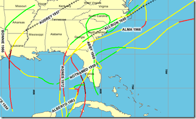
Although the tropics don’t usually begin to seriously rock & roll until August, early season storms can occur.  Below are a few notable June Hurricanes, including 1957’s Audrey – a CATEGORY 4 storm.


image


So Memorial day weekend isn’t too soon to be preparing.  Hurricane Alma in 1966 struck Florida on June 9th.


A word is in order about the Hurricane forecast track issued by the National Hurricane Center in Miami. 


Below you’ll find two forecast maps for Hurricane IKE in 2008  – six days apart – with the first showing a hit on Miami and the second a strike on the Texas Coast.


Ike Path


On September 4th they had the storm 5 days out from Miami, but instead it went in on the northeastern side of Cuba, crossed Cuba twice, then emerged into the Gulf of Mexico where it intensified and proceeded on to Texas.


Did the NHC screw up?


A closer look of the first forecast map will show that it struck Cuba well within the `zone of probability’ issued on September 4th.  Miami was the center of the zone, true enough. 


But five days out, the NHC said it could hit anywhere from Cuba to Jacksonville.  So no . . . the NHC  did not screw up. 


The lesson here is, Hurricane forecasts are pretty reliable 24 hours out, but less so at 48hrs.  The margin of error increases at 3, 4, and 5 days in advance.  Which is why the NHC warns people to pay more attention to the `forecast cone’, than to the centerline.


This year, due to better forecasting techniques, the NHC will extend its Hurricane and tropical storm watches and warnings lead time by an additional 12 hours. Warnings will now be issued 36 hours in advance and watches 48 hour.


But once again, if you are in the 48 hour `cone’, you need to consider yourself vulnerable.

Since my home would be untenable in any hurricane, I’ve already secured a couple of evacuation locations for myself should a serious storm threaten my area.   I hope to get one or two more.


I’ve no desire to load up my car and start driving (along with hundreds of thousands of other evacuees) in search of a non-existent motel room.


Yes, there are usually public shelters opened in hurricane areas.  But these should be shelters of last resort, reserved for those who were unable (or unwilling) to make other plans.  


Besides, anyone who has stayed in one of these shelters will be quick to tell you that they leave a lot to be desired in the comfort department.   If you can do better, you’d be well advised to do so.


I’ve got my 72 hr `bug out bag’ already packed. For a complete description, follow the link to Inside My Bug Out Bag, but here are a few pictures of what I keep at the ready 24/7.


Bugout


I’ve also a `packing list’ of other items, and can have my car loaded, and ready to go, in less than a hour.  I keep a serious first aid kit in the trunk at all times, and as I’m packing I’ll be running a fresh backup of my computer onto a USB Flash drive.  


My `extra supplies’ will extend my ability to be self sufficient to a week or longer.


I also carry (in my wallet) my full medical history, just in case I’m injured or sick, and unable to provide it to emergency personnel.  (See Those Who Forget Their History . . .). 


Of course, I also have insurance information, Photo ID’s, some cash, pharmacy and Doctor information, and contact names and phone numbers for those out of the area where I can leave word of my status if need be.


If you don’t intend to evacuate (and if you are in a safe & secure location, you really shouldn’t), you need to make sure you can fend for yourself (and your family) for at least 72 hours – up to a week or longer .


Remember, after a major storm:

  • The power may be out for days or longer. 
  • Phones may be inoperable (including cell phones). 
  • Your water may be off, or contaminated. 
  • Streets may be impassible, or dangerous, due to downed wires or tree limbs.
  • And emergency crews may have their hands full and be unable to respond quickly . . . assuming you can even call for help.


After the storm hits is no time to be scrambling for things like food, water, or first aid supplies.  Things that are relatively easy to do today, may be all but impossible to do later.

National Hurricane Preparedness Week: Day 6


# 4603


Today is day six of  National Hurricane Preparedness Week, and the focus today is on preparedness.


Hurricane Prep Week


One of the toughest jobs for emergency planners is to get the public to prepare for a disaster while the sun is still shining.  Until a threat looms large, most people simply don’t bother.  


But by that time, it may be too late. 


Essential items often disappear from store shelves in advance of a storm, and frankly, it takes time and serious thought to decide what really is important, and what isn’t.


Here is some of the information provided by the National Hurricane Center on preparedness.


Be Prepared
"Preventing the loss of life and minimizing the damage to property from hurricanes are responsibilities that are shared by all
."

Hurricane Season: Are You Prepared?Throughout this Web site, information has been provided regarding actions that you can take based on specific hurricane hazards. The most important thing that you can do is to be informed and prepared. Disaster prevention includes both being prepared as well as reducing damages (mitigation).

Disaster Prevention should include:

One of the most important decisions you will have to make is "Should I Evacuate?"


If you are asked to evacuate, you should do so without delay.

But unless you live in a coastal or low-lying area, an area that floods frequently, or in manufactured housing, it is unlikely that emergency managers will ask you to evacuate. That means that it is important for you and your family to HAVE A PLAN that makes you as safe as possible in your home.


Disaster prevention includes modifying your home to strengthen it against storms so that you can be as safe as possible. It also includes having the supplies on hand to weather the storm. The suggestions provided here are only guides. You should use common sense in your disaster prevention.


  • DEVELOP A FAMILY PLAN - Your family's plan should be based on your vulnerability to the Hurricane Hazards. You should keep a written plan and share your plan with other friends or family.
  • CREATE A DISASTER SUPPLY KIT - There are certain items you need to have regardless of where you ride out a hurricane. The disaster supply kit is a useful tool when you evacuate as well as making you as safe as possible in your home.
  • SECURE YOUR HOME - There are things that you can do to make your home more secure and able to withstand stronger storms.
  • ONLINE VULNERABILITY INFO - There are web sites that can give you information about your communities vulnerability to specific hazards. These include hurricanes as well as other weather related hazards.


Family Disaster Plan

check markDiscuss the type of hazards that could affect your family. Know your home's vulnerability to storm surge, flooding and wind.

check markLocate a safe room or the safest areas in your home for each hurricane hazard. In certain circumstances the safest areas may not be your home but within your community.

check markDetermine escape routes from your home and places to meet. These should be measured in tens of miles rather than hundreds of miles.

check markHave an out-of-state friend as a family contact, so all your family members have a single point of contact.

check markMake a plan now for what to do with your pets if you need to evacuate.

check markPost emergency telephone numbers by your phones and make sure your children know how and when to call 911.

check markCheck your insurance coverage - flood damage is not usually covered by homeowners insurance.

check markStock non-perishable emergency supplies and a Disaster Supply Kit.

check markUse a NOAA weather radio. Remember to replace its battery every 6 months, as you do with your smoke detectors.

check markTake First Aid, CPR and disaster preparedness classes.


Disaster Supply Kit

Water - at least 1 gallon daily per person for 3 to 7 days

Food - at least enough for 3 to 7 days
— non-perishable packaged or canned food / juices
— foods for infants or the elderly
— snack foods
— non-electric can opener
— cooking tools / fuel
— paper plates / plastic utensils

Blankets / Pillows, etc.

Clothing - seasonal / rain gear/ sturdy shoes

First Aid Kit / Medicines / Prescription Drugs

Special Items - for babies and the elderly

Toiletries / Hygiene items / Moisture wipes

Flashlight / Batteries

Radio - Battery operated and NOAA weather radio

Telephones - Fully charged cell phone with extra battery and a traditional (not cordless) telephone set

Cash (with some small bills) and Credit Cards - Banks and ATMs may not be available for extended periods

Keys

Toys, Books and Games

Important documents - in a waterproof container or watertight resealable plastic bag
— insurance, medical records, bank account numbers, Social Security card, etc.

Tools - keep a set with you during the storm

Vehicle fuel tanks filled

Pet care items
— proper identification / immunization records / medications
— ample supply of food and water
— a carrier or cage
— muzzle and leash


Once a storm appears to be targeting your area, you may only have a few hours to prepare or evacuate.

Some essential hurricane resources to get you started include:


http://www.fema.gov/hazard/hurricane/index.shtm


http://www.ready.gov/america/beinformed/hurricanes.html


Later today (or perhaps tomorrow), I’ll be back with my own personal hurricane disaster plan, along with other hurricane information, in A Hurricane Reality Check.

BMJ: Immunogenicity Of Adjuvanted vs. Unadjuvanted H1N1 Vaccines


# 4602


Last year, as many of you will recall, there was a huge debate over the inclusion of adjuvants in the pandemic vaccine – additives that help boost the immune response and lower the amount of antigen needed for each shot.


By using adjuvants, the limited supply of antigen could be used to make more flu shots, and immunize more people.


Another plus to  using adjuvants is that they can induce a wider range of cross-protection, meaning that as a virus `drifts’ antigenically over time, an adjuvanted vaccine is more likely to remain protective. 


Although some adjuvants have been used for years (alum and aluminum salts are incorporated into some diphtheria, tetanus and pertussis vaccines), their use in flu vaccines had been limited.


Unfortunately that meant we had limited data on their safety and effectiveness, particularly in children and pregnant women.  And that lack of data gave a lot of people pause.


So much so, that the decision here in the United States was to go with an unadjuvanted vaccine.  Authorities feared that the incorporation of an adjuvant would deter some people from taking the vaccine.    


And in fact, one of the reasons cited for the low uptake of pandemic vaccine in Europe was public concern over the inclusion of adjuvants in the vaccine.


Now that millions of doses of adjuvanted vaccine have been administered to people of all ages, we are starting to get research papers on their safety and effectiveness.   


Today, we get a head-to-head comparison of GSK’s Pandemrix, containing the adjuvant AS03, verses Baxter’s unadjuvanted Celvapan in British children.


Although the adjuvanted Pandemrix vaccine was associated with a higher rate of (usually mild) side effects (fever, injection site soreness), it produced a superior immune response.  


Children under the age of three receiving Pandemrix showed an impressive  98.2 % immune response rate, compared to just over 80% with the unadjuvanted Celvapan.


For older children, the difference was less pronounced, with 99.1% after 2 doses of Pandemrix verses 95.9% for Celvapan.


Excerpts from the BMJ research article follow.  The entire study is available for free.


Cite this as: BMJ 2010;340:c2649

Research

Safety and immunogenicity of AS03B adjuvanted split virion versus non-adjuvanted whole virion H1N1 influenza vaccine in UK children aged 6 months-12 years: open label, randomised, parallel group, multicentre study

Claire S Waddington, clinical research fellow, et al.

Abstract

Objectives To compare the safety, reactogenicity, and immunogenicity of an adjuvanted split virion H1N1 vaccine and a non-adjuvanted whole virion vaccine used in the pandemic immunisation programme in the United Kingdom.


Design Open label, randomised, parallel group, phase II study.
Setting Five UK centres (Oxford, Southampton, Bristol, Exeter, and London).


Participants Children aged 6 months to less than 13 years for whom a parent or guardian had provided written informed consent and who were able to comply with study procedures were eligible. Those with laboratory confirmed pandemic H1N1 influenza or clinically diagnosed disease meriting antiviral treatment, allergy to egg or any other vaccine components, or coagulation defects, or who were severely immunocompromised or had recently received blood products were excluded. Children were grouped by age: 6 months-<3 years (younger group) and 3-<13 years (older group). Recruitment was by media advertising and direct mailing. Recruitment visits were attended by 949 participants, of whom 943 were enrolled and 937 included in the per protocol analysis.


<SNIP>


Conclusions In this first direct comparison of an AS03B adjuvanted split virion versus whole virion non-adjuvanted H1N1 vaccine, the adjuvanted vaccine, while more reactogenic, was more immunogenic and, importantly, achieved high seroconversion rates in children aged less than 3 years. This indicates the potential for improved immunogenicity of influenza vaccines in this age group.

Thursday, May 27, 2010

NOAA 2010 Atlantic Hurricane Outlook


# 4601


Today NOAA (National Oceanic and Atmospheric Administration) issued their updated `forecast’ (an outlook, really) for this year’s Atlantic Hurricane season.


Yesterday, if you will recall, two hurricane researchers from the University of Colorado (Dr. William Grey & Dr. Phil Klozbach) stated they expected `a hell of a year’. 


Apparently NOAA experts agree.  They are anticipating 14 to 23 Named Storms, 8 to 14 Hurricanes of which 3 to 7 could be Major Hurricanes


Along with this seasonal outlook , NOAA Administrator Dr. Jane Lubchenco  discussed with FEMA Administrator Craig Fugate the critical need for storm preparedness.


NOAA Expects Busy Atlantic Hurricane Season

May 27, 2010

Hurricane Ike.

Hurricane Ike, 2008.


An “active to extremely active” hurricane season is expected for the Atlantic Basin this year according to the seasonal outlook issued today by NOAA’s Climate Prediction Center – a division of the National Weather Service. As with every hurricane season, this outlook underscores the importance of having a hurricane preparedness plan in place.

Across the entire Atlantic Basin for the six-month season, which begins June 1, NOAA is projecting a 70 percent probability of the following ranges:

  • 14 to 23 Named Storms (top winds of 39 mph or higher), including:
  • 8 to 14 Hurricanes (top winds of 74 mph or higher), of which:
  • 3 to 7 could be Major Hurricanes (Category 3, 4 or 5; winds of at least 111 mph)

“If this outlook holds true, this season could be one of the more active on record,” said Jane Lubchenco, Ph.D., under secretary of commerce for oceans and atmosphere and NOAA administrator. “The greater likelihood of storms brings an increased risk of a landfall. In short, we urge everyone to be prepared.”

The outlook ranges exceed the seasonal average of 11 named storms, six hurricanes and two major hurricanes. Expected factors supporting this outlook are:

  • Upper atmospheric winds conducive for storms. Wind shear, which can tear apart storms, will be weaker since El Niño in the eastern Pacific has dissipated. Strong wind shear helped suppress storm development during the 2009 hurricane season.
  • Warm Atlantic Ocean water. Sea surface temperatures are expected to remain above average where storms often develop and move across the Atlantic. Record warm temperatures – up to four degrees Fahrenheit above average – are now present in this region.
  • High activity era continues. Since 1995, the tropical multi-decadal signal has brought favorable ocean and atmospheric conditions in sync, leading to more active hurricane seasons. Eight of the last 15 seasons rank in the top ten for the most named storms with 2005 in first place with 28 named storms.

(Continue . . . )


Today is day five of  National Hurricane Preparedness Week, and the focus today is on Forecasting.

Hurricane Prep Week


WATCH vs. WARNING - KNOW THE DIFFERENCE

  • TROPICAL STORM WATCH: An announcement that tropical storm conditions (sustained winds of 39 to 73 mph) are possible within the specified coastal area within 48 hours.
  • TROPICAL STORM WARNING: An announcement that tropical storm conditions (sustained winds of 39 to 73 mph) are expected somewhere within the specified coastal area within 36 hours.
  • HURRICANE WATCH: An announcement that hurricane conditions (sustained winds of 74 mph or higher) are possible within the specified coastal area. Because hurricane preparedness activities become difficult once winds reach tropical storm force, the hurricane watch is issued 48 hours in advance of the anticipated onset of tropical-storm-force winds.
  • HURRICANE WARNING: An announcement that hurricane conditions (sustained winds of 74 mph or higher) are expected somewhere within the specified coastal area. Because hurricane preparedness activities become difficult once winds reach tropical storm force, the hurricane warning is issued 36 hours in advance of the anticipated onset of tropical-storm-force winds.

The Worst That Could Happen


# 4600


As a (former) paramedic, I’m used to thinking about and preparing for the `worst case scenario’.  Hurricanes, plane crashes, chemical spills . . . you name it.  It is part of the job description.


Thankfully, they don’t happen very often.


In fact, most of the extreme situations we trained for simply didn’t happen on my watch.  But over the years, just about all of them have happened on somebody’s watch.  


A few recent examples include:


Haitian Earthquake (2010)

Sichuan earthquake (2008)

Katrina (2005)

Indonesian Tsunami (2004)

World Trade Center (2001)


As disconcerting as it may be to think about, emergency planners and response agencies don’t have the luxury to ignore `worst-case scenarios’.  It is their job to prepare for them.


Later today we’ll be getting the revised 2010 Atlantic Hurricane Outlook from NOAA, and most experts are anticipating that we’ll see a busy year.


While no one can predict months in advance where hurricanes will hit, or how strong they will be when they do, emergency planners do have their `worry list’; Heavily populated areas of the coastline that are at particularly high risk from major hurricanes.


The damage expected from a Category 4 or 5 storm is 100 times greater than that from a Category 1 Hurricane.


Since most people have never experienced a CAT 5 storm, or its aftermath, it might be useful to look at how NOAA describes its impact.  This from the newly revised Saffir-Simpson Scale  (emphasis mine):


Category 5

Winds (1 min sustained winds in mph and km/hr) 155MPH

Catastrophic damage will occur

People, livestock, and pets are at very high risk of injury or death from flying or falling debris, even if indoors in mobile homes or framed homes.


Almost complete destruction of all mobile homes will occur, regardless of age or construction.


A high percentage of frame homes will be destroyed, with total roof failure and wall collapse. Extensive damage to roof covers, windows, and doors will occur. Large amounts of windborne debris will be lofted into the air. Windborne debris damage will occur to nearly all unprotected windows and many protected windows.


Significant damage to wood roof commercial buildings will occur due to loss of roof sheathing. Complete collapse of many older metal buildings can occur. Most unreinforced masonry walls will fail which can lead to the collapse of the buildings. A high percentage of industrial buildings and low-rise apartment buildings will be destroyed.


Nearly all windows will be blown out of high-rise buildings resulting in falling glass, which will pose a threat for days to weeks after the storm.


Nearly all commercial signage, fences, and canopies will be destroyed.


Nearly all trees will be snapped or uprooted and power poles downed.

Fallen trees and power poles will isolate residential areas.

Power outages will last for weeks to possibly months. Long-term water shortages will increase human suffering. Most of the area will be uninhabitable for weeks or months.


If this sounds extreme, it is. 


But it is exactly what happened to Homestead, Florida in 1992 with Hurricane Andrew, and to the Mississippi Gulf coast in 1969 in the wake of Hurricane Camille.


And it doesn’t take an (admittedly) rare land falling CAT 5 storm to do incredible damage.  Katrina was barely a CAT 3 when it devastated New Orleans.


From an insured loss standpoint, the 10 worst places for an extreme hurricane to strike are:


image


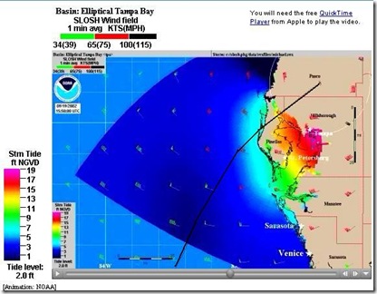
What you see below is a SLOSH Model (Sea, Lake, Overland, Surge, from Hurricanes) depicting a CAT 4 storm coming in just north of St Petersburg (Tarpon Springs), driving a wall of water up into Tampa Bay.  


TBAY Slosh1


Some areas of St. Pete and Tampa would have 15-18 feet of water on top of them.   And at the point where I snapped this image, the storm would be sitting just about on top of what ever is left of my home.


You can view the entire animation HERE.


Houston, Texas is another highly vulnerable area.  Here is a 10 second SLOSH model for that community.


A couple of years ago the State of Florida held an exercise on a `worst-case’ imaginary hurricane; Hurricane Ono  ( Think: “Oh No!”). 


A CAT 5 storm that would come in at Miami, cross the state and exit around Tampa, re-intensify in the Gulf, and then strike Pensacola as a CAT 4.


You can read more about this scenario here.

image


This path is remarkably similar to the path of the Great Miami Hurricane of 1926, which killed hundreds in South Florida.


image


Hopefully, won’t see a `worst-case scenario’ this year.


But it will happen again.  If not this year, perhaps next year, or the year after.  


The Saffir-Simpson Scale description of a CAT 5’s damage is admittedly the worst-case scenario, but is worth remembering as you think about and prepare for this hurricane season. :


Power outages will last for weeks to possibly months. Long-term water shortages will increase human suffering. Most of the area will be uninhabitable for weeks or months. 


Which is why it is imperative that people living in vulnerable areas heed evacuation warnings, that they prepare to weather the storm and it's aftermath . . .  and that they take all of this very, very seriously.

Australian Doc: ICU’s Were On `Verge of Collapse’ During Pandemic


#  4599


Despite years of planning and preparing for a much worse pandemic (which may yet come), hospitals – particularly ICUs – in many regions around the world found themselves severely tested during the peak of the 2009 pandemic.


The vast majority of people who contracted this virus recovered without incident, but for something less than 1% of those infected, swine flu proved far more serious.  


Today, a detailed overview of how ICU’s in Australia coped with the influx of patients last year – and hopefully, some lessons learned – from ABC (Australia) News.


Swine flu put hospitals 'on edge' last year › News in Science (ABC Science)

Thursday, 27 May 2010 Helen Carter
ABC


Australia's intensive care system was on the verge of collapse for the first time ever during last year's swine flu epidemic, according to one intensive care physician.


Associate Professor Steve Webb from the Royal Perth Hospital hopes lessons learnt in 2009, together with vaccination, and the fact many now have some immunity to swine flu, will help prevent a repeat scenario this year.


Webb will tell the Australasian Society for Infectious Diseases annual scientific conference in Darwin this week that early diagnosis and treatment with antivirals is vital, as is expanding the ICU system, to cope with admissions.


Webb and colleagues recently investigated influenza H1N1 (swine flu) admissions to all 187 intensive care units (ICUs) in Australia and New Zealand in 2009.


"ICUs were on the point of collapse which was unprecedented. The ICU system in every region in Australia came close to collapse and we've learnt a great deal from that and will be better prepared to manage ICU surge capacity this year," says Webb.


"One Sydney doctor said that in one week during last year's flu season, his intensive care unit saw more people with severe acute respiratory distress than in any other week of his 30 year career in intensive care...There was a massive wave of very sick people."


(Continue . . . )


The sobering lesson here, of course, is that we remain woefully unprepared to deal with a truly severe pandemic. 


A repeat of 1918 could be 100 times worse than what we saw in 2009.   While that may never happen, history suggests that we shouldn’t take that for granted.


Obviously, no health care system can prepared adequately for a `worst-case’ pandemic.   


But when a `mild-to-moderate’ pandemic tests our health care capacity the way H1N1 did, it demonstrates just how vulnerable we are to even a moderately severe public health crisis.

Wednesday, May 26, 2010

Experts Warn Of An Active Hurricane Season


# 4598


Every Spring scientists look at variables like Atlantic SST’s (Sea Surface Temperatures), whether the Pacific is in an El Nino – neutral – or in a La Nina pattern, and a host of other climatological indicators in an attempt to divine what kind of hurricane season we might expect.


Some years, they get it right.  Some years, they don’t.


Tomorrow, May 27th,  at 10:00AM ET NOAA will release their 2010 hurricane season forecast via a conference call.  But today, a pair of well known hurricane experts gave their own assessment.


'Hell of a year' for hurricanes, experts warn

Record warm seas for May; storms could complicate Gulf oil disaster

Image: Ships work at spill site


These ships are among the hundreds working in the Gulf of Mexico to cap and cleanup the BP oil spill. That work could see delays if storms develop this hurricane season, which runs from June to November.

FORT LAUDERDALE, Fla. - The threat of an above-average 2010 Atlantic hurricane season has increased over the last month and it now promises to be "very active," two leading forecasters said Wednesday. The warning comes as the season also sees an unusual factor added to the mix: the Gulf oil disaster.


William Gray and Phil Klozbach, who head the respected Colorado State University hurricane forecast team, said they would ramp up their prediction for the 2010 season in a report due out on June 2.


"The numbers are going to go up quite high," Gray said. "This looks like a hell of a year."

(Continue . . . )


While predictions of active seasons are interesting, and potentially useful for emergency planners, the reality is it only takes one major land falling hurricane to make for a very bad year for a whole lot of people.


It does appear that El Nino is weakening in the Pacific, and in about half the time when that happens the Pacific slips into a La Nina – which reduces wind shear in the Atlantic which is considered conducive for hurricane formation.   


Water temps in the Atlantic and the Gulf of Mexico are also running above normal, and warm waters feed the `engine’ of a hurricane.


So the ingredients that many experts believe contribute to an active season are in place.   There are other factors we understand less well, and so these forecasts are subject to considerable error.


Will it be `a hell of a year’?


Stay tuned.


In any event, I’ll have the NOAA forecast from the National Hurricane Center in a blog late tomorrow morning.


NOAA to Issue 2010 Atlantic Hurricane Season Outlook

NOAA will release its initial seasonal outlook for the 2010 Atlantic hurricane season during a press conference on May 27 in Washington, D.C. NOAA Administrator Dr. Jane Lubchenco will discuss the outlook with FEMA Administrator Craig Fugate highlighting the critical need for storm preparedness.

WHAT:

Press conference announcing NOAA’s 2010 Atlantic hurricane season outlook.

WHEN:

Thursday, May 27, 2010; 10am ET

Hurricanes and Inland Flooding


# 4597


Note: I’m having intermittent Internet problems (the tech is on his way for the 2nd visit in 2 days), so I’ll make this a short post.


Today is day four of  National Hurricane Preparedness Week, and the focus today is on inland flooding.


Hurricane Prep Week


On Saturday, I listed some of the major inland flooding events caused by hurricanes in You Don’t Have To Live On The Coast.


This is from NOAA’s Hurricane Preparedness page.

 
Inland Flooding
"In the 1970s, '80s, and '90s, inland flooding was responsible for more than half of the deaths associated with tropical cyclones in the United States."

Ed Rappaport


National Hurricane CenterWhen it comes to hurricanes, wind speeds do not tell the whole story. Hurricanes produce storm surges, tornadoes, and often the most deadly of all - inland flooding.


While storm surge is always a potential threat, more people have died from inland flooding from 1970 up to 2000. Intense rainfall is not directly related to the wind speed of tropical cyclones. In fact, some of the greatest rainfall amounts occur from weaker storms that drift slowly or stall over an area.


Inland flooding can be a major threat to communities hundreds of miles from the coast as intense rain falls from these huge tropical air masses.

(Continue. . . )


image


Other AFD blogs for this year’s National Hurricane Preparedness Week series include:

Why I’ll Be Gone With The Wind

Storm Surge Monday

The Crossroads Of The Atlantic Storm Season

You Don’t Have To Live On The Coast

Live Video Of `Top Kill’ Attempt


# 4596


For a time yesterday, it looked like BP would shut down the live video feed from a mile deep in the Gulf of Mexico of the attempt to cap the blown out Deepwater Horizon rig.  


Last night, reportedly under pressure from the government, BP agreed to leave the feeds in place.


In the event you already don’t know how to access these live video streams, I’ve a few urls for you.   Demand is likely to be heavy during this attempt to shut down the well (which may take 48 hours), so having a `plan B’ site to watch it on is probably a good idea.


CBS News, broadcasting on USTREAM, has a very good feed.


image


TheState.com has  a live video feed on this page.


CNN has streaming video along with other oil spill related video reports here.


And BP has their own video feed  here.


Obviously the stakes here are very high.  BP only gives a 60%-70% chance of success.    


For more information on the Deepwater Horizon response you may wish to visit the official site of the Deepwater Horizon Response Unified Command.


For other resources, visit Florida Deepwater Horizon FAQ & Resources