Wednesday, August 31, 2011

OIE Statement On H5N1 Clade 2.3.2.1


# 5799


We’ve already seen statements from the FAO (see FAO Warns On Bird Flu) and the World Health Organization (see WHO Statement On New Bird Flu Clade) regarding this week’s big bird flu news.  


Now it is the OIE’s (World Organisation For Animal Health) turn.


My thanks go to Giuseppe Michieli who posted the link to this OIE statement on FluTrackers today.


Avian influenza H5N1 clade 2.3.2.1

Paris, 31 August 2011 – OIE closely follows the evolution of avian influenza in domestic and wild birds around the world, and acknowledges the recent identification of an H5N1 virus described as clade 2.3.2.1.


Small genetic changes are known to routinely occur in influenza A viruses, including those that may affect humans or animals. The emergence of the H5N1 virus, such as clade 2.3.2.1 is one of such genetic mutations taking place as part of the natural evolution of the virus. This is not immediate cause for alert but, as with the emergence of any new strain, reinforces the need for sustained monitoring of viruses in animal populations so that changes in viruses circulating in the field are detected at an earliest stage and that most appropriate disease control strategies are chosen to best protect animal and public health.


OIE recommends keeping up with active surveillance in bird populations, encouraging national Veterinary Services to be prepared to quickly report and respond to unusual animal disease events that may represent more serious disease in animals or that may pose increased  risk to humans.


As is the case with human influenza vaccines whose composition needs to be reviewed every year, avian influenza vaccines need to be regularly tested to check whether they effectively combat the viruses circulating in the field. OIE Reference Laboratories and other partner laboratories are actively involved in ongoing surveillance and development of good quality vaccines that match the viruses of concern. The OIE Reference Laboratory in Harbin, China, has developed a new vaccine seed strain that experimentally protects poultry from the identified H5N1 virus clade 2.3.2.1. This vaccine, once available for field use, will be used in countries where H5N1 virus clade 2.3.2.1 has been identified. Registration and manufacturing of a poultry vaccine with the new seed strain is in progress.


OIE and OFFLU’s guidance on early detection and rapid response to animal disease events prove crucial in the prevention and control of animal influenzas, with positive implications for human health. OFFLU is a joint OIE/FAO worldwide network of expertise on avian influenza. It also provides animal influenza data to the World Health Organization regularly to assist with the selection of candidate influenza vaccines for humans.

Study: Hospital Uniforms And Bacteria


image

Photo Credit CDC PHIL 


# 5798


HAIs, or Hospital Acquired Infections, take an incredible toll on patient’s health and our health care system every year. 


According to the HHS, they rank among the top ten leading causes of death in the United States, and accounted for an estimated 1.7 million infections and 99,000 associated deaths in 2002.


While hospitals are constantly working to reduce the incidence of HAIs, it is a daunting task.  We live in a  germy world, and the opportunities to spread bacteria in a healthcare setting are abundant.


Studies have shown that while compliance rates are improving, up to 50% of health care workers in the United States may fail to consistently wash their hands between patients (cite).


This year, the World Health Organization designated May 5th as global  CLEAN YOUR HANDS DAY - to encourage HCWs (Healthcare workers) to improve and sustain hand hygiene practices around the world (see A Movement With Five Moments).


One of the ongoing concerns regarding nosocomial transmission of pathogens has been that lab coats, neckties, and long sleeves might help to spread harmful bacteria from patient to patient in a healthcare facility.


In response, in 2007 the NHS banned the wearing of long-sleeved white coats, wristwatches, and neckties by HCWs in hospital wards, and in 2009 the AMA (American Medical Assoc.) considered a “bare below the elbows” dress code during their annual meeting, but decided the issue needed more study (see Lab Coat Legislation).


The rap against lab coats and neckties has primarily been that they are not usually freshly laundered every day.


One recent study showed that 62% of doctors surveyed waited 2-weeks or longer to launder their coats. 


While that sounds like a bit of a red flag, earlier this year we saw a study (see The Long And The Short Of It) that found no statistical difference between the amount of bacteria of freshly laundered short sleeve uniforms versus infrequently laundered white coats after only 8 hours wear.


And what isn’t known is how well pathogens transfer from contaminated uniforms to the surrounding environment, or on to patients.


Today, another study appears in APIC’s American Journal of Infection Control, that looks at the prevalence of harmful bacteria on uniforms worn in a university-affiliated hospital in Israel.


The areas of each uniform tested were the abdominal zone, sleeves' ends and pockets.


Potentially pathogenic bacteria were isolated from the uniforms of 85 participants (63%) and were detected in half the samples taken.


They found 21 cultures from the nurses uniforms and 6 from physician uniforms grew multi-drug resistant pathogens, including 8 that grew MRSA.


While a bit disconcerting, given the environment in which these uniforms are worn, and previous studies we’ve seen, these results are not all that surprising.


The abstract can be read at:


AJIC: American Journal of Infection Control
Volume 39, Issue 7 , Pages 555-559, September 2011

Nursing and physician attire as possible source of nosocomial infections

Conclusion

Up to 60% of hospital staff’s uniforms are colonized with potentially pathogenic bacteria, including drug-resistant organisms. It remains to be determined whether these bacteria can be transferred to patients and cause clinically relevant infection.


In an Elsevier Health Services Press Release (Doctors' and nurses' hospital uniforms contain dangerous bacteria majority of the time, study shows), APIC President Russell Olmsted, MPH, CIC is quoted as saying:


"It is important to put these study results into perspective. Any clothing that is worn by humans will become contaminated with microorganisms. The cornerstone of infection prevention remains the use of hand hygiene to prevent the movement of microbes from these surfaces to patients.


New evidence such as this study by Dr. Wiener-Well is helpful to improve the understanding of potential sources of contamination but, as is true for many studies, it raises additional questions that need to be investigated."


Last year, according to Infection Control Today, the American Medical Association (AMA)  announced plans to begin formal research on "textile transmission of infections" singling out the "physician's white lab coat as a primary concern associated with textile transmission of infections."


Promising new technologies, including bacteria-resistant fabrics, are being developed in hopes that they will reduce HAIs.


But for now, more research is needed to determine just how much of a role contaminated uniforms really play in the spread of harmful pathogens to patients in the hospital.

WHO Statement On New Bird Flu Clade


# 5797


The World Health Organization has posted a brief statement regarding the FAO’s warning earlier this week (see FAO Warns On Bird Flu) of a mutated strain of the H5N1 virus circulating in China and Vietnam.


This FAO announcement has been widely reported by the press, and over the past 48 hours has elicited some criticism (see Australian CMO Calls Bird Flu Warning `Overstated’) for stating that this emerging strain poses `unpredictable risks to human health.”


Given the amount of press coverage this statement has received, the WHO has sought to clarify matters with the following statement.


Evolution of H5N1 avian influenza virus does not increase risk to public health

30 August 2011 -- WHO closely monitors the evolution of influenza viruses and is aware of recent reports of an H5N1 virus (described as H5N1 clade 2.3.2.1) circulating in poultry in parts of Asia. Based on available information, this evolution of the H5N1 virus poses no increased risk to public health. It is not considered unusual because influenza viruses are constantly evolving, especially in areas where they circulate regularly in poultry.


The WHO Global Influenza Surveillance and Response System, the group of experts that studies animal and human influenza viruses that may impact human health, recognized this new clade in February 2011.


WHO also routinely assesses the public health risk from all animal influenza viruses. Based on available information, the identification of this newly-reported H5N1 virus clade does not change the current public health implications of the H5N1 avian influenza viruses for humans. Human cases of H5N1 infection remain rare and sporadic events, occurring mostly in areas where H5N1 viruses circulate regularly in poultry. Human cases could occur wherever the viruses are present in poultry and when humans might be exposed to infected birds or contaminated environments.


As I wrote yesterday, we’ve no indications that this new strain of H5N1 is any more likely to be transmitted to, or among, humans than the earlier strains.


What we are seeing is viral evolution in action.  And for influenza viruses, the only constant is change.


For now, this new clade presents the biggest challenge to poultry farmers in countries where it is now endemic. Current vaccines do not protect livestock against it, and so the fear is it will spread further across Asia.


And that could not only result in substantial losses in countries already dealing with low food security, it could potentially expose more people (along with a variety of non-human hosts) to the virus.


Providing the H5N1 virus with more opportunities to evolve and adapt.


Hence the calls for increased surveillance and vigilance.


Not so much for what the public health threat of the H5N1 virus is today, but for what it might become in the future.

Tuesday, August 30, 2011

CDC Webinar: Leveraging Social Media For Disaster Preparedness


# 5796


Tomorrow, August 31st from 1:00 PM to 2:00 PM EDT, the CDC will present a webinar on the role of social media in disaster preparedness.


Details on how to attend online can be found at the web page below.


Leveraging Social Media for Disaster Preparedness

Join us on Wednesday, August 31st, 2011 1:00 PM (ET) for a special webinar presentation "Leveraging Social Media for Disaster Preparedness."


This presentation will begin by laying out the major areas where social media is being used in emergency preparedness, response, and recovery. The presenter will discuss the ways that social media can be leveraged to enhance situational awareness, strengthen operational aspects of response, support recovery efforts, and build community resilience.

(Continue . . . )

image

Australian CMO Calls Bird Flu Warning `Overstated’


# 5795


With many newspaper headlines screaming the words `Mutant Bird Flu’ in their headlines these past 24 hours, not everyone is happy with the wording of the FAO’s recent announcement.


Australia’s new CMO (Chief Medical Officer) Professor Chris Baggoley, who took office this week, has called the warning `overstated’.


To read his comments, and concerns, you can visit Radio Australia’s article called:


Australian medical chief talks down Asian bird flu fears


While the media has, a bit predictably, latched onto the more sensationalized human implications of this mutation, the primary threat at this time is to poultry.


So far, the H5N1 virus remains poorly adapted to human physiology.


The FAO announcement (see FAO Warns On Bird Flu) simply stated that this new strain “is spreading in Asia and beyond, with unpredictable risks to human health.”


While perhaps not the most reassuring statement in the world, it happens to be true.


To be clear, we’ve no indications that this new strain of H5N1 is any more likely to be transmitted to, or among, humans than the earlier strains. And human infections from the bird flu virus, thus far, have been mercifully few in number.


No one knows if the H5N1 virus will ever develop the ability to transmit efficiently among humans.


And there are other influenza viruses out there with perhaps even a greater chance of sparking the next pandemic.


While one can argue that the threat of a bird flu pandemic remains remote, the FAO has a responsibility to alert us whenever they have knowledge of an emerging zoonotic health concern.


One can only imagine the howls of protest should H5N1 suddenly emerge as an imminent threat and the appropriate agencies had failed to warn us.


Given the circumstances, simply stating the truth  . . .  that this new strain poses `unpredictable risks to human health’, hardly seems alarmist. 

Professor Peter Doherty On Bird Flu


# 5794


With yesterday’s FAO announcement (see FAO Warns On Bird Flu), the H5N1 virus is suddenly back in the news cycle again.


Today, the Australian Life Scientist Magazine carries an interview with world renown, 1996 Nobel Prize winning scientist Professor Peter Doherty, who discusses the pandemic potential of this avian virus.


Although his comments range from research on GM (genetically modified) flu-resistant chickens to universal flu vaccines, the main thrust of the today’s article centers around the possibility that the H5N1 virus might one day swap genes (reassort) with the H1N1 virus and produce an easily transmitted, highly virulent flu strain.


First a link to the article, which is very much worth reading, then I’ll return with more.


Bird-swine flu hybrid could be a killer combo

The appearance of a new mutant of bird flu in Asia raises the concern that it might hybridise with swine flu creating a new pandemic threat.

  • Tim Dean (Australian Life Scientist)
  • 30 August, 2011 17:12


As we’ve discussed before, influenza viruses change, evolve, or mutate over time via two well established routes; Antigenic drift and Antigenic Shift.


Antigenic drift – the more common of the two - causes small, incremental changes in the virus over time.  Drift is the standard evolutionary process by which influenza viruses mutate, and often come about due to replication errors that are common with single-strand RNA viruses.


Shift occurs when one virus swap out chunks of their genetic code with gene segments from another virus.  This is known as reassortment. While far less common than drift, shift can produce abrupt, dramatic, and sometimes pandemic inducing changes to the virus.


This process has produced pandemic flu strains in the past, and while that obviously doesn’t happen often, virologists are quick to remind us:


Shift Happens.


mixing vessel


While reassortment can occur in many species, pigs have long been believed to be an ideal `mixing vessel’ for influenza because they possess both avian-like (SAα2,3Gal) and human-like (SAα2,6Gal) receptor cells in their respiratory tract.


That makes pigs susceptible to human, swine, and avian strains of flu. And while it may not happen often, they are capable of being infected by more than one flu virus at a time.


This is basically how the 2009 H1N1 pandemic virus evolved, although it took multiple gene swaps over a decade or longer before it finally emerged into the human population.


We know that reassortments do happen, but only rarely do they result in a biologically fit virus capable of causing a pandemic.


Most hybrid viruses are evolutionary dead-ends, are unable to compete, and die out within the host.


But as global pig production grows – particularly in places where biosecurity and surveillance may be lax – it creates increasing opportunities for a new, biologically `fit’  virus to emerge.


image

Source: FAO


Lest anyone doubt the ability of pigs to contract the H5N1 virus, a little over a year ago (see EID Journal: Asymptomatic H5N1 In Pigs) we saw research out of Indonesia that showed 52 pigs in 4 provinces were found to be infected with H5N1 between 2005–2007. 


While there is justifiable concern over a reassorted H5N1 virus, bird flu isn’t the only pandemic player down on the farm.


The H9 and H7 avian viruses, along with various strains of H3 and H1 influenza (and others) are all potential candidates for reassortment.


For more on the reassortment potential of avian, swine, and human flu viruses, you can’t do better than  Helen Branswell’s excellent Scientific American article from last December called Flu Factories, or her SciAm Podcast interview.


And for good measure, a sampling of a few of my earlier blogs on reassortment:


Review: Evolution & Adaptation Of The 2009 pdmH1N1 Virus
You Say You Want An Evolution?
EID Journal: Co-Infection By Influenza Strains
EID Journal: Swine Flu Reassortants In Pigs
If You’ve Seen One Triple Reassortant Swine Flu Virus . . .


Monday, August 29, 2011

Referral: McPherson On Fujian H5N1


# 5793


To the dismay of his readers, Scott McPherson doesn’t blog as often as he did a couple of years ago. Today however he’s updated his blog, and since some folks may be out of the habit of checking his site, I wanted to mention that he’s blogging again.


For his take on the big flu story of today - a news release from the FAO on the resurgence of bird flu - go read:


FAO warns of spread of Fujian H5N1 mutation

FAO Warns On Bird Flu


image

Photo Credit – FAO


# 5792


Although we generally talk about the H5N1 bird flu as if it were a single entity – in reality there have been more than a dozen clades of the virus identified - with numerous variants within each clade.


You can see an overview of the evolution of the H5N1 virus over the years in the graphic below.


image

For more on this evolution see Variations On A Bird Flu Theme.


H5N1, like all influenza A viruses, is constantly under pressure to change and mutate, looking for a biological advantage. Most of these mutations, thankfully, are evolutionary dead ends and fail to spread and thrive.


But in this viral version of king-of-the-hill, nature occasionally produces a more `fit’ and competitive virus, and it begins to dominate and spread.


One of these `new’ clades making inroads over the past few years has been 2.3.2.  I wrote of the spread of this emerging clade earlier this year in What Goes Around, Comes Around and EID Journal: H5N1 Branching Out).


Somewhat ominously, last Spring we began to see reports of poultry vaccine failures in Vietnam due to the spread of a mutated version this clade (further classified as clade 2.3.2.1).


In late May Vietnam announced a cessation of poultry vaccinations until a new formulation could be developed (see Reuters Vietnam halts bird flu vaccination due to new type).


Which brings us to a press release, issued today by the United Nation’s Food and Agriculture Organization (FAO), warning of a possible resurgence of the H5N1 virus this fall and winter, in part due to the emergence and spread of this new clade of the virus.


Bird Flu rears its head again

29-08-2011

Increased preparedness and surveillance urged against variant strain

29 August 2011, Rome - FAO today urged heightened readiness and surveillance against a possible major resurgence of the H5N1 Highly Pathogenic Avian Influenza amid signs that a mutant strain of the deadly Bird Flu virus is spreading in Asia and beyond, with unpredictable risks to human health.


The H5N1 virus has infected 565 people since it first appeared in 2003, killing 331 of them, according to WHO figures. The latest death occurred earlier this month in Cambodia, which has registered eight cases of human infection this year -- all of them fatal.


Since 2003 H5N1 has killed or forced the culling of more than 400 million domestic poultry and caused an estimated $20 billion of economic damage across the globe before it was eliminated from most of the 63 countries infected at its peak in 2006.


However, the virus remained endemic in six nations, although the number of outbreaks in domestic poultry and wild bird populations shrank steadily from an annual peak of 4000 to just 302 in mid 2008. But outbreaks have risen progressively since, with almost 800 cases recorded in 2010-2011.

Virus spread in both poultry and wild birds

At the same time, 2008 marked the beginning of renewed geographic expansion of the H5N1 virus both in poultry and wild birds.


The advance appears to be associated with migratory bird movements, according to FAO Chief Veterinary Officer Juan Lubroth. He said migrations help the virus travel over long distances, so that H5N1 has in the past 24 months shown up in poultry or wild birds in countries that had been virus-free for several years.


"Wild birds may introduce the virus, but peoples' actions in poultry production and marketing spread it," Lubroth noted.


Recently affected areas are to be found in Israel and the Palestinian Territories, Bulgaria, Romania, Nepal and Mongolia.


A further cause for concern, Lubroth said, is the appearance in China and Viet Nam of a variant virus apparently able to sidestep the defences provided by existing vaccines.


In Viet Nam, which suspended its springtime poultry vaccination campaign this year, most of the northern and central parts of the country -- where H5N1 is endemic -- have been invaded by the new virus strain, known as H5N1 - 2.3.2.1.

High alert

Viet Nam's veterinary services are on high alert and reportedly considering a novel, targeted vaccination campaign this fall. Virus circulation in Viet Nam poses a direct threat to Cambodia, Thailand and Malaysia as well as endangering the Korean peninsula and Japan further afield. Wild bird migration can also spread the virus to other continents.


"The general departure from the progressive decline observed in 2004-2008 could mean that there will be a flareup of H5N1 this fall and winter, with people unexpectedly finding the virus in their backyard," Lubroth said.


The countries where H5N1 is still firmly entrenched – Bangladesh, China, Egypt, India, Indonesia and Vietnam – are likely to face the biggest problems but no country can consider itself safe, he said.


"Preparedness and surveillance remain essential," Lubroth underlined. "This is no time for complacency. No one can let their guard down with H5N1." 


For now H5N1 is primarily a threat to poultry.


The virus remains poorly adapted to human physiology, and despite ample opportunities in places like Egypt and Indonesia, only causes rare, sporadic infections.


The concern, of course, is that over time that may change.  And so the world remains at Pre-pandemic Phase III for the H5N1 virus, and we continue to watch for signs that the virus is adapting to humans.


image


But H5N1 is not the only pandemic threat in the wings. 


We’ve seen scattered human infections by avian H7, H9, and H11 viruses, along with rare swine flu reassortments in recent years. We could even see an increase in virulence among the human influenzas already in circulation.


While we worry most about the H5N1 virus – primarily due to its high mortality rate – nature’s laboratory continues to experiment with a growing variety of viral options.


Which is why the question it isn’t `if’ another pandemic will happen. 


It’s pretty much just a matter of when.

Sunday, August 28, 2011

Another Study On Statins And Pneumonia


image

Photo Credit CDC PHIL 

# 5791


During a major influenza pandemic, a billion people . . . perhaps more, could fall seriously ill over the course of a few short months. 


And the reality is, without pharmacological intervention, millions could die.


But flu vaccines take months to manufacture, and our ability to produce and distribute them remains woefully inadequate. Antivirals are in short supply as well, are expensive, and may produce unwanted side effects. They might even prove ineffective if the pandemic strain is resistant.


What the world desperately needs is a cheap (preferably generic) medication that will help treat severe influenza cases.


It needs to be a shelf stable pill, that is easy to dispense, has a low incidence of side effects, and can reduce influenza morbidity and mortality.  


That’s a tall order, but there are some researchers who believe that statinscholesterol lowering drugs – might fill the bill.


Over the years we’ve seen a number of studies that have suggested that taking statins can improve survival rates among those with influenza and/or pneumonia.


The idea of using them in a pandemic has been largely championed by Dr. David Fedson – former Professor of Medicine at the University of Virginia School of Medicine and formerly Director of Medical Affairs, Aventis Pasteur MSD who has urged that scientists look seriously at statins, which he believes may help modulate the immune response.


A couple of his papers on the subject include:


Pandemic Influenza: A Potential Role for Statins in Treatment and Prophylaxis

David S. Fedson


New Approaches to Confronting an Imminent Influenza Pandemic

Dr. Fedson and Peter Dunnill, DSc,FREng


In 2007 we saw a study that seemed to support the idea, as it indicated that statins lowered the mortality rate of those with pneumonia.


Statin drugs lower respiratory death risk: study

Tue Apr 10, 2007 12:40pm EDT

By Maggie Fox, Health and Science Editor

WASHINGTON (Reuters) - People who use statin drugs are less likely to die of influenza and chronic bronchitis, according to a study that shows yet another unexpected benefit of the cholesterol-lowering medications.


And in 2008  another encouraging report made the headlines:


Statins may cut pneumonia death, blood clot risks

27 Oct 2008 20:00:13 GMT

Source: Reuters

By Will Dunham

WASHINGTON, Oct 27 (Reuters) - Cholesterol-fighting drugs known as statins reduced the risk of dying from pneumonia or developing dangerous blood clots in the legs, adding to a growing list of benefits from the popular drugs, two research groups said on Monday.


But not all of the studies have been positive.


In July of 2009 there was a report that found no evidence of benefit among pneumonia patients (see Another Take On Statins And Pneumonia) taking statins.


But more recent studies (here and here) have suggested that those on statins see lower mortality from both seasonal flu and pneumonia. Keeping alive the possibility that statins might play some role in mitigating a future pandemic.


Conflicting medical studies are nothing new.  We see them all the time.  Science is often messy and we get to the truth by fits and starts – and that can sometimes take years to sort out.  


Today, we have another study to add to the mix. 


This one comes from Imperial College London, where researchers conducted an 11 year follow up on thousands of UK patients who took part in a landmark statin study (ASCOT Anglo-Scandinavian Cardiac Outcomes Trial) that ended in 2003.


What they found was that those who received statins during the initial trial period (as opposed to a placebo), were 14% less likely to have died over the past 11 years. 


This despite the fact that a large number of the placebo group had begun taking statins in the interim.


The difference in mortality was, quite unexpectedly, attributed to fewer deaths from respiratory infections and pneumonia. In fact, statins appeared to have a greater affect on reducing mortality due to respiratory infections than they did on cardiovascular disease.


We’ve a press release and a link to the study.


Statins reduce deaths from infection and respiratory illness, 8 years on from trial

The death rate among patients prescribed a statin in a major trial that ended in 2003 is still lower than those given a placebo, even though most participants in both groups have been taking statins ever since. ASCOT, the Anglo-Scandinavian Cardiac Outcomes Trial, was stopped early because the statin was so effective at preventing heart attacks and strokes, but a new analysis has shown that eight years on, the most significant difference between the groups is a reduction in deaths from infection and respiratory illness.


The latest findings, from researchers at Imperial College London, were presented at the European Society of Cardiology Congress in Paris today and simultaneously published in the European Heart Journal.


In the lipid-lowering arm of the trial, over 10,000 patients in the UK, Ireland and Scandinavia with high blood pressure were randomly allocated either atorvastatin or placebo between 1998 and 2000. In 2003, the trial was stopped early because the statin proved to be highly beneficial in preventing heart attacks and strokes. Since then, most participants from both groups have been taking statins.


The new analysis looked at the number and cause of deaths among the 4,605 participants in the ASCOT trial who are based in the UK. After 11 years' follow-up, overall mortality is 14 per cent lower in the group originally assigned atorvastatin, due largely to fewer deaths from infection and respiratory illness.


"This result is very unexpected," said Professor Peter Sever, from the International Centre for Circulatory Health at Imperial College London, who led the study. "The benefits of statins for preventing heart attacks and strokes are well-established, but after long-term follow-up the most significant effects seem to be on deaths from other causes. It's quite remarkable that there is still this difference between the two groups, eight years after the trial finished.”

(Continue . . . )


The study may be read at:


The Anglo-Scandinavian Cardiac Outcomes Trial: 11-year mortality follow-up of the lipid-lowering arm in the UK

Peter S. Sever*, Choon L. Chang, Ajay K. Gupta, Andrew Whitehouse, Neil R. Poulter and on behalf of the ASCOT Investigators


Conclusion Legacy effects of those originally assigned atorvastatin may contribute to long-term benefits on all-cause mortality. An explanation for long-term benefits on non-CV deaths has not been established.


This study (like most) is subject to a number of limitations, including that these researchers did not set out, a priori, to study non-CV deaths, that it was limited to a large segment of the UK cohort of the original ASCOT trial, and that cause of death was taken from available death certificates, which are not always 100% accurate.


Still, the authors believe this study shows a positive effect from early (and probably sustained)use of statins on all-cause mortality.


In an accompanying editorial, Guy G. De Backer calls the results `surprising’, but notes they leave us with with a great many unanswered questions. Not the least of which is what mechanism might be behind this legacy effect of taking statins.


Long-term results from statin trials: answers but more unresolved questions

Guy G. De Backer


While today’s information is tantalizing, definitive answers remain elusive. Better studies are obviously needed - preferably from multiple randomized controlled trials (RCTs).


But studies on the legacy effects of medications can take years, and are both difficult and expensive to mount. So it may be quite some time before we get those answers.


For more on the potential utilization of statins during a pandemic, or for seasonal influenza and pneumonia, you may wish to revisit these earlier blogs:


Statins & Pneumonia: Revisited

Referral: Effect Measure On Statins

Statins Revisited

First Statins, Now Fibrates

Not Quite Goodnight For Irene


image

# 5790


Although not the nightmare storm that many envisioned, Hurricane Irene has left between 2 and 3 million people in her path without power, has damaged homes, businesses and local infrastructure, produced serious flooding, and has reportedly claimed the lives of at least 9 people over the past couple of days.


And while a minimal hurricane as of the 5am update from the NHC, she isn’t done yet.  She will pass over Long Island later this morning before moving inland over New England this afternoon.


The National Hurricane Center describes the storm’s condition this morning:


HURRICANE FORCE WINDS EXTEND OUTWARD UP TO 125 MILES...205 KM...FROM THE CENTER...AND TROPICAL STORM FORCE WINDS EXTEND OUTWARD UP TO 320 MILES...520 KM.  LA GUARDIA AIRPORT IN NEW YORK CITY RECENTLY REPORTED A SUSTAINED WIND OF 41 MPH...67 KM/H...AND A WIND GUST OF 64 MPH...104 KM/H.  A SUSTAINED WIND OF 40 MPH...65 KM/H...AND A WIND GUST OF 58 MPH...93 KM/H...WERE ALSO RECENTLY REPORTED AT JOHN F. KENNEDY INTERNATIONAL AIRPORT IN NEW YORK CITY.


WATER LEVELS HAVE BEEN RISING RAPIDLY IN ADVANCE OF THE CENTER OF IRENE...WITH RECENTLY OBSERVED STORM SURGE VALUES OF 3.9 FEET AT SANDY HOOK NEW JERSEY...3.8 FEET AT NEW YORK HARBOR...AND 3.1 FEET AT CAPE MAY NEW JERSEY.


Reports out of Norfolk, Va. indicated they saw a nearly 8 foot surge in some areas.  It may be a day or two before we can get reliable estimates from along the North Carolina coast.


Typical of the reports this morning: In Pennsylvania, more than 200,000 are without power, and according to PSE&G, it may take several days to restore electricity.


PSE&G Hurricane Irene Update: Aug. 28, 2011 at 5:30 a.m.

-- About 213,000 PSE&G customers are without power at this time statewide. The number of outages continues to climb as Hurricane Irene moves north. The utility, which provides electric service to 2.2 million customers, is estimating that power restoration may take several days to a week


There have also been reports of possible tornadoes spun up from Irene damaging homes and felling trees in Delaware, and New York City and many surrounding areas have been under tornado warnings and/or watches overnight.


While obviously not catastrophic, it will take a few days before we get a decent idea of just how much damage Irene has actually caused. 


Meanwhile, the NHC indicates there are a couple of new areas of suspicion brewing in the Atlantic, and we are just now coming up to the most active month in the Hurricane season.


image


Reason enough to make sure that you, your family, and your business are ready in case another storm heads in our direction.

Saturday, August 27, 2011

Of Hurricanes, Pandemics, And Intensity Forecasting


image

Irene looking a little ragged this morning


# 5789


For hurricanes, life is short and environmental threats to their existence are many. 


It takes the right balance of environmental factors; low wind shear, warm waters to traverse and feed from, little or no interaction with land masses, and abundant moist tropical air to keep them going full tilt.


Take away, or reduce any of these vital  components, and even powerful storms can quickly lose strength or fall apart altogether. 


Irene, which was forecast to be a major (Cat 3) hurricane at landfall only 24 hours ago, has instead weakened overnight into a strong CAT 1 storm, with sustained winds of 90 MPH and higher gusts.


Of course, even at CAT 1 strength, Irene is not something to trifle with. She is still capable of producing a serious amount of damage, particularly from storm surge, so those in her path should not let their guard down.


But her impact is likely to be less than originally feared.


From the 5am NHC discussion:


LAND INTERACTION...DRY AIR ENTRAINMENT...AND INCREASING VERTICALWIND SHEAR SHOULD CAUSE IRENE TO WEAKEN AS IT MOVES ALONG THE U.S. EAST  COAST. HOWEVER...THE CYCLONE IS EXPECTED TO REMAIN A HURRICANE WITH A VERY LARGE WIND FIELD UNTIL AFTER LANDFALL IN NEW ENGLAND.  EXTRATROPICAL TRANSITION SHOULD OCCUR AFTER THE NEW ENGLAND LANDFALL...WITH IRENE GRADUALLY WEAKENING FROM 48-120 HR.


As I’ve mentioned in the past, the  National Hurricane Center’s confidence in their intensity forecasting is less than in their forecast tracks.


The science is improving, but the number of constantly changing variables involved is absolutely staggering, and so storm intensity remains difficult to predict.


The conditions supporting a stronger Irene appeared to be in place.


She was far enough from land as to suffer little interference, the waters she was passing over were still relatively warm, and wind shear – although beginning to increase - had been low for the past several days.


But it appears that Irene has been weakened by the entrainment of drier air, pulled into the storm from the west. 


While there may be some who will claim the NHC overstated the dangers, and in doing so disrupted the lives of millions of people this weekend, the truth is this storm could easily have gone the other way, and become stronger.


And when it is your job to provide 48 hours warning of what could be a major threat, you can’t weasel-word your warnings just to give yourself a convenient `out’.


The conditions were there to keep Irene a major storm at landfall, and so with lives at stake, the only prudent thing was to assume that could happen.


A situation not so dissimilar to what public health officials faced a little over 2 years ago when a novel influenza virus emerged, and began spreading rapidly around the globe.


Despite many unknowns, the conditions were in place to support the declaration of a pandemic. Even though the World Health Organization stated the severity was impossible to predict, they were forced to assume the worst, and plan accordingly.


As with the NHC warnings on Irene, it was the right thing to do.


The fact that the pandemic proved less severe than first thought was pure luck. The next time, we may not be so fortunate.


Sadly, many people who ride through Irene this weekend may decide that hurricanes aren’t so bad after all. They will think they’ve gone through a major storm, when they really haven’t, and may fail to listen to officials and take prudent steps the next time a storm threatens.


Just like the millions of people who now believe that another flu pandemic isn’t anything to worry about, since the last one was so mild.


Since past performance is no guarantee of future results, either assumption could prove disastrous down the road.


The bottom line:  Even if we are lucky enough to dodge a bullet today . . . 


We shouldn’t assume ourselves to be bulletproof tomorrow.

Friday, August 26, 2011

Monitoring Irene’s Trek Online


# 5788


The internet provides a unique platform for watching Irene’s trek across the mid-Altantic states, with resources that include live coastal radars, NOAA  weather radio broadcasts, streaming radio and TV coverage from cities all across the region,  beach front and traffic webcams and even scanners to listen to local emergency radio traffic.


For those in the path of the storm, or those with friends or family in the affected area, this can help provide valuable information as to what is going on during and after the storm.


And for those who are simply curious as to the impact of this hurricane, this is a convenient way to monitor it.


This afternoon, and probably again later in the weekend, I intend to post some of the web resources I’ll be monitoring as the storm comes ashore. 


Disclaimer: These links are offered without warranty or endorsement (except for the NHC & NOAA links), and you visit them at your own risk

It is always prudent to use up-to-date antivirus software, and decline to install any software from vendors you do not trust, when surfing the net.


The focus today with be on North Carolina, where Irene is expected to make landfall tomorrow morning, but I’ll provide links further up the coast in a later post.


Nearly all of these links are subject to storm related outages and bandwidth limitations, so don’t be surprised if you find some of them offline during the course of the next couple of days.


First stop, of course, is the National Hurricane Center in Miami, Florida that tracks the storm.  You can also visit the Wilmington, NC and Newport/Morehead City, NC National Weather Service Weather Forecast Offices (WFO) for local advisories.


image


Similarly, NOAA Weather Radio All Hazards broadcasts are available online as live streaming audio although they are hosted by other entities, including Weather Underground.


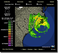
Via Weather Underground we’ve a couple of live radar feeds you can access.  You can just begin to see Irene’s eye in this snapshot taken at 3:00 pm EST today on the Wilmington Radar.

image


A little further north you’ll find the Morehead City radar.

image


Interesting, but often frustrating and requiring patience, are the live streaming webcams scattered across North Carolina. These camera feeds tend to suffer from heavy web traffic, are sometimes poorly maintained, and are prone to going offline when a storm strikes.


Still, there are plenty to choose from, and when you can connect, they can make for interesting viewing.


Raleigh broadcaster WRAL.Com has an interactive map with a number of these cams available.  Fair warning: About half of the ones I checked were not currently accessible.


image


WRAL also has a page with streaming traffic cams from across the state.


Traffic Camera Video tease 540x50

Watch recently captured video from major highways in the Triangle area. Video clips show approximate time that the video was captured. Clips, taken from locations in Wake, Durham and Orange counties, last about 15 seconds are updated about every 4 minutes.


For a list of North Carolina TV stations, some of which will be providing live, 24-hour streaming coverage of Irene’s arrival, you can go to:


North Carolina TV stations


You’ll have to find steaming coverage by trial and error, as some stations may not be streaming.


Live streaming audio is also available from a number of radio stations in North Carolina.  A webpage with links to their websites can be found at:


Streaming Radio Guide


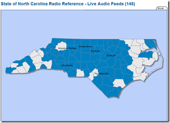
More than 140 local, county and state emergency services frequencies (fire, police, EMS) can be assessed via RadioReference.com.  The interactive maps shows counties with scanner monitoring. Click on the county, and you’ll be presented with a list of feeds.


image


Hurricane City, a well known hurricane tracking site and forum, broadcasts on USTREAM when hurricanes approach the coast and you can watch it HERE.


You’ll also find live hurricane coverage and chaser cam footage from Mark Sudduth’s HurricaneTrack.com.


Emergency Stream provides live, raw, and uncut audio and video feeds from all over the country.  Frankly, there’s no telling what you will find there.  Local TV broadcasts, raw helicopter camera feeds, etc.


 image

Your best option is to select either audio or video feeds, and then the state from the list that appears on the right side of the page. These links are transient, so some channels may be active while others are not. 


Check all of the links, and check back often.


USTREAM, mentioned earlier, provides a venue for all types of broadcasting.  Enter  HURRICANE  or IRENE in the search box for a list of current streaming video. You’ll find everything from storm chaser video to live feeds from hotels on the Altantic beaches.


Since anyone can broadcast on USTREAM, accept anything you see or hear cautiously. Still, USTREAM can be a terrific resource.


I’ll try to have more resources later, and will update this blog post if I find anything tonight. But this should give you a pretty good start on following the storm.

A Prescription For Disasters


# 5787


Photo Credit – Wikipedia Commons


I’ve written before of my visit to New Orleans five weeks after Katrina struck to help my twin brother retrieve what belongings we could from his French Quarter apartment.  


While we were in town one of his planned tasks was to get refills on his prescriptions from his local pharmacy.  But 5 weeks after the storm, his Mom & Pop pharmacy was still shuttered and vacant.


Like thousands of others post-Katrina, he was in a bind.


He had no way of contacting his doctor, no way to prove he had refills left at his pharmacy, and would be forced to find a new doctor and schedule an appointment in order to get new prescriptions.


For my brother, it wasn’t a life or death situation.  But for many others, daily medications are literally a matter of survival. 


Maintaining an adequate supply of essential prescription medication in your emergency kit, along with copies of your prescriptions, is an important part of individual and family preparedness.


Most doctors will gladly write an extra 14 or 30 day `disaster stash’ script for your most vital medications if you express your concern, and the AMA endorsed this idea several years ago (see AMA Now Supports Personal Rx Stockpiling For Disasters).


Depending upon your insurance coverage, you may have to pay for them out of pocket, but it certainly beats the alternative.


And if you do obtain a disaster stash, make sure to use and rotate those meds before they expire.


FEMA has long recommended that those with special needs make special preparations.


Considerations for people responsible for disabled individuals:

  • For those on respirators or other electric-powered medical equipment, make prior arrangements with your physician or check with your oxygen supplier about emergency plans, and be sure to have electrical back-up for any medical equipment.
  • Maintain a two-week supply of items such as dressings, nasal cannulas and suction catheters.
  • Maintain a two-week supply of both prescription and non-prescription medications.
  • Keep copies of your medical records.
  • Keep copies of prescriptions for medical equipment, supplies and medications.
  • Keep extra contact lenses and supplies, extra eyeglasses and extra batteries for hearing aids.
  • Make plans now to have accessible transportation in case of evacuation.
  • Shelters may be limited in accommodations to meet some of the needs of those with disabilities. Prepare ahead of time to ensure you will have what you need.


There are federal  programs designed to assist those in a federally declared disaster zone with their emergency prescription needs.  It is called EPAP or Emergency Prescription Assistance Program.

The goals of EPAP are to:

  • Ensure access to covered prescription drugs and DME for eligible individuals who present at a pharmacy with a valid prescription, at no cost to the affected individual.
  • Implement real-time point-of-sale eligibility checks and system edits for claims where the pharmacist has found no other coverage to limit dispensing of EPAP covered drugs and DME to eligible individuals.
  • Facilitate legitimate pharmacy claims from new pharmacy locations and other out of network pharmacies on an as-needed basis.


But of course, you’ll need to be able to prove you are eligible and that you have a valid prescription (see Eligibility Information Sheet For Emergency Prescription Assistance Program (EPAP)).


And depending upon the size and scope of the disaster, there could be delays in getting your prescriptions processed. 


So having an extra supply on hand is still important.


As is knowing what to do if your prescriptions are damaged in a disaster.   Here, the FDA offers some advice.


Safe Drug Use After a Natural Disaster

The Center for Drug Evaluation and Research (CDER) at the FDA offers the following information on the use of drugs that have been potentially affected by fire, flooding or unsafe water and the use of temperature-sensitive drug products when refrigeration is temporarily unavailable.

(Continue . . . )


And on a related subject, everyone should have a readily available (preferably carried in your wallet or purse), EMERGENCY medical history.


I addressed that issue in a blog called Those Who Forget Their History . . . .   A few excerpts (but follow the link to read the whole thing):


Since you can’t always know, in advance, when you might need medical care it is important to carry with you some kind of medical history at all times.  It can tell doctors important information about your history, medications, and allergies when you can’t.


Many hospitals and pharmacies provide – either free, or for a very nominal sum – folding wallet medical history forms with a plastic sleeve to protect them.


I’ve scanned the one offered by one of our local hospitals below. It is rudimentary, but covers the basics.

medhx1

medhx2

In a medical emergency, minutes can make the difference between life and death.  And even in less urgent cases, having all of this information can go a long ways towards speeding your treatment.


While disasters like hurricanes, floods, and earthquakes are never pleasant experiences, the things we do in advance of them can make the difference between being inconvenienced and uncomfortable, and being irreparably harmed.


Those with special medical needs are all the more vulnerable during a disaster, and so extra preparations are warranted.

Australia Reports Cluster Of Antiviral Resistant H1N1


# 5786


Since it first appeared in the spring of 2009, scientists have worried that the H1N1 swine flu would someday develop resistance to the antiviral medication oseltamivir (Roche’s Tamiflu ®) as its predecessor - seasonal H1N1 - did in 2008.


Overall, however, the news has been generally good.


During the first two years, only 1%-2% of samples tested have shown the most common mutation known to convey oseltamivir resistance; H275Y, where a single amino acid substitution (histidine (H) to tyrosine (Y)) occurs at the neuraminidase position 275.


(Note: some scientists use 'N2 numbering' (H274Y) and some use 'N1 numbering' (H275Y))


Most of these cases of antiviral resistance occurred spontaneously in people after being treated with the drug, and quite often involved immunocompromised individuals.


Yesterday, ProMed Mail published a report from Australia on an unusual and worrisome cluster of oseltamivir resistance in New South Wales.  More than 2 dozen patients – roughly 14% of the isolates tested from that region since May – have shown the H275Y mutation.


INFLUENZA (50): AUSTRALIA (NEW SOUTH WALES), H275Y MUTATION CLUSTER

********************************************************
A ProMED-mail post
http://www.promedmail.org
ProMED-mail is a program of the
International Society for Infectious Diseases
http://www.isid.org
Date: Thu 24 Aug 2011
From: Kate Hardie


A cluster of oseltamivir-resistant A(H1N1)2009 influenza cases with onset between May and August 2011 has been detected in the Hunter region of New South Wales (NSW), Australia.


Viruses from 25 of 184 (14 percent) A(H1N1)2009 cases from the Hunter New England region exhibited highly reduced oseltamivir sensitivity due to the H275Y substitution in the neuraminidase. The H275Y mutation is a well-established substitution previously reported to confer oseltamivir resistance in N1 neuraminidases and was present in the widespread oseltamivir resistant pre-pandemic seasonal A(H1N1) virus.

(Continue . . . )


Significantly, none of the cases reportedly took the antiviral prior to their flu test, and in follow up interviews with 16 of these cases, none have a history of being immunocompromised.


Jason Gale, writing for Bloomberg News, has more details, including some quotes from World Health Organization officials on this finding.


Tamiflu-Resistant Flu Outbreak Reported in Australia’s Newcastle, WHO Says

By Jason Gale - Aug 25, 2011 9:25 PM ET


For now, the H1N1 virus remains overwhelmingly sensitive to oseltamivir, even in the New South Wales region where all of these cases are located. And the H1N1 virus with the H275Y mutation remains sensitive to GSK’s Relenza, an alternative antiviral.


The concern is that this appears to be a biologically fit, easily transmitted strain of H1N1 and that it might eventually spread beyond this region.


Which is exactly what we saw happen with the old seasonal H1N1 virus, when in early 2008 Norway began to report a rise in resistant samples, and less than a year later the resistant strain was the predominant strain around the world.


It’s a crowded viral field out there, and whether this resistant strain can compete with the numerous non-resistant strains of H1N1 on the global stage is something we will have to wait to see.


This is a compelling enough reason, however, to get that seasonal flu shot this year. It is better to try to prevent the flu, than to have to treat it. 


image

Photo Credit PHIL


Particularly if treatment options should become more limited in the future.

Irene: 36 Hours Out


# 5785


Although Irene has failed to strengthen (and has actually weakened slightly overnight), she remains a large and formidable storm with sustained winds of 110 MPH. 


Irene is traveling over very warm waters that are conducive to maintaining, or perhaps even increasing, her strength and is now just about 36 hours away from an anticipated landfall along the North Carolina coast.


This is a very large storm with hurricane force winds extending as far as 90 miles from its center, and tropical force winds 290 miles. Her impact will be widely felt along a long stretch of the coast and further inland, and will affect millions of people over the next 72 hours.


image


For residents along the mid-Atlantic coastline, today is the last day to make any last minute preparations, and to leave if you must. Residents need to pay close attention to their local office of emergency management, and if advised to evacuate, do so immediately.


One of the biggest threats along the coastline will likely come from storm surge.The following video from the NHC (National Hurricane Center) illustrates this danger.


(Storm Tide vs Surge Tide) – Credit NOAA


Depending upon many factors - such as the size and strength of the storm, its angle of approach, the depth of the water, and the shape of the coastline - storm surges in some coastal areas have run 20 feet or more.


The last major landfalling hurricane in the United States was Ike, in 2008.  Below is a photo of the remnants of Crystal Beach, Texas after being scoured by wind, wave, and surge.


Hence the need to evacuate low lying coastal areas.  A `sturdy’ shelter isn’t always a safe shelter.


The National Hurricane Center has an interactive storm surge map  showing the probabilities of various levels of surge along the coast. Below you’ll see a map showing the probabilities of a 6 foot + storm surge from Irene this weekend.


image


The NHC also maintains a current list of local Hurricane statements from various National Weather Bureaus regarding Irene. If you live in any of these areas you should consult them to get the best information for your area.


These statements are also available at weather.gov


This weekend’s hurricane threat is exactly the reason why FEMA, Ready.gov, and many other agencies are continually urging everyone to:


image


Having an emergency `to go’ kit or `BOB’ is an important part of your preparations, and could literally save your life in an emergency.


In the vernacular, a `bug-out bag'  or `BOB’ is a bag of emergency supplies, ideally kept at the ready, that one can grab on the way out the door during an emergency.


Every hurricane I go through my personal bug out bag, and replace flashlight and radio batteries from last year, and swap out older emergency rations for newer ones.


A BOB isn't supposed to be a survival kit, but rather, is supposed to provide the essentials one might need during the first 72 hours of a forced, and sometimes unexpected, evacuation.


It should contain food, water, any essential prescription medicines, copies of important papers (ID's, insurance, important Phone #s), a first aid kit, portable radio, flashlight, extra batteries, and ideally blankets and extra clothes.


You can view the contents of my BOB in Inside My Bug Out Bag.


Ready.gov has the following advice on how to prepare for an evacuation order.


Evacuating

There may be conditions under which you will decide to get away, or there may be situations when you are ordered to leave. Plan how you will assemble your family and anticipate where you will go. Choose several destinations in different directions so you have options in an emergency.

Create an evacuation plan:
    • Plan places where your family will meet, both within and outside of your immediate neighborhood.
    • If you have a car, keep a half tank of gas in it at all times in case you need to evacuate.
    • Become familiar with alternate routes and other means of transportation out of your area.
    • If you do not have a car, plan how you will leave if you have to.
    • Take your emergency supply kit unless you have reason to believe it has been contaminated.
    • Lock the door behind you.
  • Take your pets with you, but understand that only service animals may be permitted in public shelters. Plan how you will care for your pets in an emergency.

    If time allows:

    • Call or email the "out-of-state" contact in your family communications plan.
    • Tell them where you are going.
    • If there is damage to your home and you are instructed to do so, shut off water, gas and electricity before leaving.
    • Leave a note telling others when you left and where you are going.
    • Check with neighbors who may need a ride.


No one wants to leave their home in an emergency, but sometimes there is no other rational choice. Many who failed to heed the evacuation order in New Orleans prior to the arrival of hurricane Katrina didn’t survive.


Being prepared to evacuate in advance will not only make the process easier, it could be lifesaving as well.